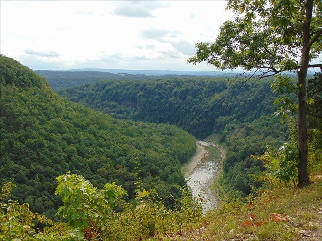
Letchworth State Park, often referred to as the 'Grand Canyon of the East', is one of most magnificent parks in the east coast. The Genesee River winds its way through the gorge, over three major waterfalls, between cliffs which are as high as 600 feet, surrounded by lush forests. The posted coordinates are for the Great Bend Overlook which offers breathtaking views of the river below as it winds it way through the gorge.
The rock layers beneath Letchworth are composed of shale, siltstone, and sandstone, that were deposited in a shallow sea that covered the region during the Late Devonian Period (382.7 ±2.7 mya to 358.9 ±2.7 mya). Great quantities of sand and silt which were eroded off high eastern mountains over millions of years were squeezed under millions of tons of pressure developed into sandstone, silt, and shale. This shallow sea that once covered the region is why Devonian Period rocks contain numerous fossils and are known to contain trilobites, brachiopods, and crinoids.
Rocks in the lower part of the gorge consist mainly of black to gray shales, while upstream progressively younger rocks are exposed which feature increasing amounts of siltstone and sandstone. The physical character of the gorge varies along its length. The upper and lower section of the gorge are deep and narrow, cut into the rock while the middle section is still a deep, but relatively flat bottomed valley. These differences reflect area where the Genesee River has cut new gorges through the rock versus where it had flown through an older section of gorge.
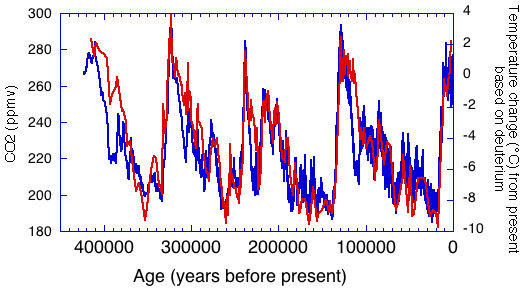
Two million years ago, a massive layer of snow and ice two mile thick began to flow, forming a massive continental ice sheet. As the chart shows, the temperatures fluctuated over time, which led to the southern edge of this glacier retreated and advanced several times, scraping, pushing, and dragging huge volumes of rock and soil. Twelve thousand years ago, the Genesee River's northward trek was blocked by the Valley Heads moraine near Portageville (Wyoming County), and forced over the rocky Letchworth Plateau. The steep and narrow newer sections in the upper and lower reaches have been eroded out while the middle section runs through an older section of gorge. Other parts of the older gorge, where the river no longer flows have been filled up with glacial till and lake sediment.
Logging Requirements
- Observe the gorge from the overlook. Is it deep and narrow, or is it deep with a relatively flat bottomed valley? Based on your observations, is the section of gorge before you an older or newer section?
- From the overlook, can you see any layers in the wall on the other side of the gorge? How many layers are you able to count? Are they all the same color, or are some layers different colors?
- Estimate the height of the canyon wall at this location. Is this one of the deepest sections of gorge in the park, or one of the shallowest?
- (Optional) Post some pictures of the view, or any wildlife you observed in Letchworth State Park.
All answers MUST be submitted prior to logging this cache.
This cache was approved by the NYS-OPRHP and contains permit LSP-84.