The Kolob Canyons is the northwest section of Zion National Park, Utah. Located at Exit 40 on Interstate 15, 40 miles north of Zion Canyon and 17 miles south of Cedar City, it is one of the most accessible regions of the park and also one of the least visited. The Kolob Canyons are part of the Colorado Plateau and are designated as a wilderness area for their unspoiled and primitive environments. It is the home of the Kolob Arch, one of the world's largest freestanding natural arches, 310 feet long. Kolob Canyons are a unique part of Zion National Park, with soaring peaks of Navajo sandstone, canyon streams, cascading falls, and over 20 miles of hiking trails. The word "Kolob" is found in Mormon scripture and means "residence closest to heaven."
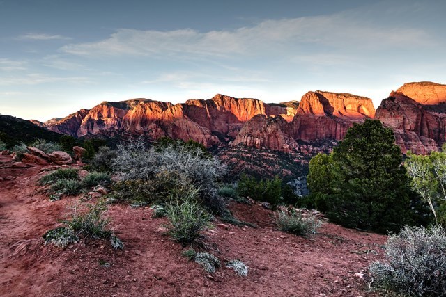
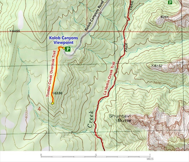
Follow the Kolob Canyon Road to the parking area for a view of the Finger Canyons. As you drive through the Canyons you will cross the Hurricane Fault, a 120 mile fracture in the earth’s crust, which gives rise to the plateau from which Zion was formed. Kolob Canyons Road ascends 1,100 feet in five miles. Take your time. Along the way are multiple scenic vistas, road side stops and information plaques. At the viewpoint you will see pale red Navajo sandstone cliffs that rise more than 2,000 feet into the sky. There is an information plaque explaining what you are looking at. It is an interesting read and I encourage you to do so.
Probably the best time to visit is at sundown when the setting sun highlights the peaks. It is likely that you will be one of the few people there. The beauty and the solitude of the mountains is something that you will not experience elsewhere.
Permission for this cache has been granted by the Zion National Park Service. Please obey all posted rules as to park hours and appropriate use. It is NOT necessary to leave the parking lot to complete this cache.
To log this cache you must complete the following:
1. First, obviously, you must actually go there.
2. At the coordinates is a plaque. To log the cache email or message me what is written in the top left and right corners.
3. Please post a picture of you or your GPS/Phone in front of the canyons. If the plaque is in your picture please make certain that the answers are not readable.
This is entirely optional:
If you do arrive before sundown you might consider hiking the Timber Creek Overlook Trail. The entrance is at the west end of the parking lot (opposite to where you are now) and is clearly marked. It is a one mile round trip with a 150 foot gradual ascent to the overlook (difficulity level = 3). The trail is sandy with loose rocks, but it is easy to follow. From the viewpoint you can look directly across at Shuntavi Butte, the valleys and peaks to the south and Red Butte standing by itself in the distance... but be sure to make it back in time to catch the sunset over the mountains. 
P.S. The picture above was taken on the trail.

Virtual Reward - 2017/2018
This Virtual Cache is part of a limited release of Virtuals created between August 24, 2017 and August 24, 2018. Only 4,000 cache owners were given the opportunity to hide a Virtual Cache. Learn more about Virtual Rewards on the Geocaching Blog.