In this day and age of technology, geocaching is assisted by a myriad of devices such as phones, GPS receivers and satellite maps, which can help guide us along our chosen route to a cache. The built in maps with marked trails, or GPX route files freely available online make navigation a whole lot simpler.
Often, when out bushwalking or climbing up a mountain to find a cache, I wonder about those men and women who were the first to explore and document a route without the assistance of modern aids, and the courage and bravery it must have taken to delve into the unknown. It is only thanks to their efforts that we have the many trails and climbs to explore today. Unfortunately not all of these early expeditions achieved a successful outcome. Case in point is the story of Edwin Lyle Vidler, who was to become the first reported recreational climbing fatality in Australia.
Vidler and his friend Albert “Bert” Salmon were experienced climbing friends, having reached the summit of many of the mountains around south-east Queensland. On this occasion they were in search of a new route to the top of Mt Lindesay, a peak located on the Queensland/NSW border. Vidler had identified a crevice in the eastern cliff face as a proposed route, but Salmon disagreed that this route was climbable. Undeterred, Vidler headed out from Brisbane alone on Christmas Eve 1928 to conquer this new route. By Saturday the 29th no word had been heard from Vidler, and Salmon organised a search party to look for his friend. Tragically, after an extensive search of the area, Salmon located the body of his friend wedged in a tree growing out of the rock face of the crevice. A detailed account of the search and discovery was reported in The Brisbane Courier edition of 4 January, 1929 and can be found here.
Due to the nature of the surrounding terrain official permission was granted to bury Vidler, on New Year’s Day 1929, in a grave located just below the base of the crevice where he fell. This crevice is now known as Vidler’s Chimney, in his honour.
SOURCES:
Trove website: The Brisbane Courier Friday 4 January, 1929 https://trove.nla.gov.au/newspaper/article/21363786?
Wikipedia website- https://en.wikipedia.org/wiki/Mount_Lindesay_(Queensland)
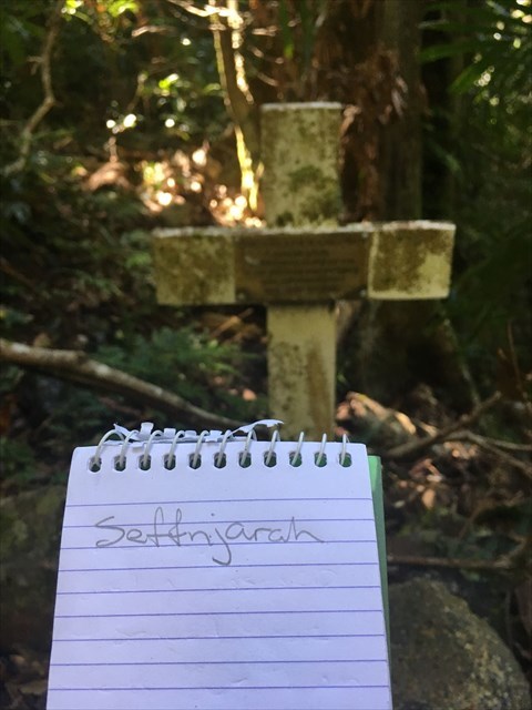
THE VIRTUAL CACHE
The grave and an associated cross are still in evidence today, and are located beside one of the trails commonly used to reach the summit of Mt Lindesay. As part of this Virtual Cache you will need to visit the grave site and pay your respects to one of the early pioneers of climbing in Queensland. In order to claim a valid find on this cache you will need to take a photo of the grave and cross, with your Geocaching user name visible and legible (e.g. written or printed on paper, written on your hand or other body part, displayed on your phone, carved into a dead branch etc – see below for an example), and add this photo to your “Found It” log. Digital additions to a photo, post your visit, will NOT be accepted so come prepared – it’s a long walk back to the car to grab a pen!
PLEASE NOTE: There is no need to touch or tamper with the grave in any way to successfully log this cache. Remember, this is someone’s burial site so act accordingly. Climbing to the top of Mt Lindesay is not required.
There are a number of ways to reach the grave site. One route is to start at the border gate at Collins Gap and follow the rabbit fence, which loops south in an anti-clockwise direction around the mountain. At approximately S28 21.078 E152 43.586 you will need to cross the fence and commence the steep climb up to the base of the cliffs, contour around to the right and then drop down from near the second cave to continue your anticlockwise contour to the grave site. It is also possible to access from the north side of the mountain from the Mt Lindesay Highway, for example following the National Park fenceline, before ascending a spur up to the northerly tip of the mountain where the eastern and western cliff faces meet and then dropping down to the grave. There are other possible routes, which some online research will reveal (please ensure you obtain appropriate permissions if any of these routes cross any private property). The above summarised descriptions are NOT meant to be a detailed guide on how to get to the grave site. As with any hike into the wilderness, your own appropriate research and planning before hand is required. I have a gpx file available (there are others available online), but ultimately it is up to your own navigational abilities to get you there and back safely. As a very rough guide, on the two occasions I have visited this site (each time coming from a different direction) the total hike time was 7 hours. You may take more or less time, depending on your abilities.
Virtual Reward - 2017/2018
This Virtual Cache is part of a limited release of Virtuals created between August 24, 2017 and August 24, 2018. Only 4,000 cache owners were given the opportunity to hide a Virtual Cache. Learn more about Virtual Rewards on the Geocaching Blog.