
Por qué Alicante fue elegida como cota cero de medición en altitud con respecto al mar de toda España.
Corría el año de 1856 (aún faltaban dos para la llegada del ferrocarril a Alicante) cuando el gobierno de su majestad Isabel II de España decidió la creación del Instituto Geográfico y Estadístico. El cual debía crear mapa topográfico de España y establecer la altitud de ciudades y accidentes geográficos con respecto a las cotas más bajas de su suelo, Aquí es donde entra Alicante.
¿Por qué se eligió nuestra ciudad? Un clima estable y su situación en el Mediterráneo con respecto a la Península, hacen posible que este enclave esté más protegido que otras ciudades costeras de España como las del Cantábrico y el Atlántico descartadas por tener variaciones de más de 4 metros, mientras que en Alicante la variación anual no supera los 20 cm. Un factor definitivo para elegir el lugar.
Además, Madrid estaba cerca, lo que -logísticamente- era también otro punto a favor para Alicante.
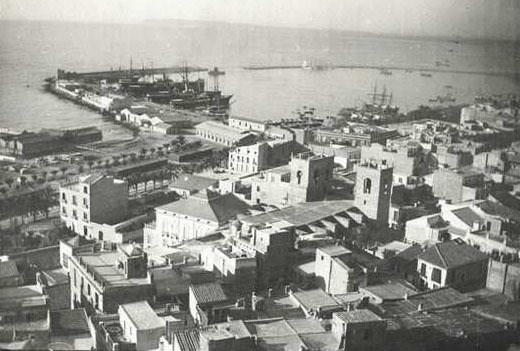
Así pues, decidido el sitio había que ponerse manos a la obra con los instrumentos necesarios para levantar un moderno y fiable mapa topográfico de España teniendo como punto de origen, como Cota Cero, la ciudad de Alicante. Aquí se instaló el primer mareógrafo de España.
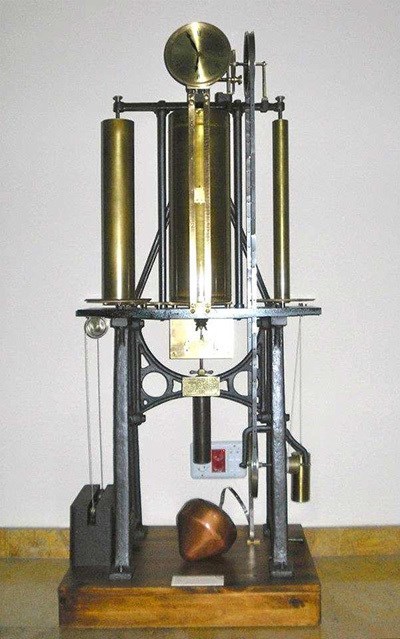
Este de la foto es un mareógrafo Thomson de 1926 que estuvo instalado en el puerto de Alicante. Durante decenios cumplió su función de medir la variación de nivel que experimenta la superficie del mar, considerando a éste como una lámina de agua exenta de oleaje. Por eso estos aparatos se ubican en el interior de las dársenas portuarias. Hoy está expuesto en el Museo del Observatorio Astronómico de Madrid.
Durante tres años y medio -desde julio de 1870 a febrero de 1874- se realizaban cuatro mediciones diarias del nivel del mar sobre una regla metálica fija situada en el inicio del muelle de Levante, concretamente en las populares escalinatas de la reina. A las 9, las 12, las 15 y las 18 horas.
Actualmente, una placa colocada por el actual Ministerio de Fomento recuerda el lugar desde donde se realizaron estas mediciones que permitieron establecer la altitud cero, la cota cero, en Alicante.

Lo que viene a indicar esta placa situada en las escaleras de la reina es que ese es el verdadero nivel cero de altitud sobre el nivel del mar, aunque todas las mediciones se efectúan desde el ayuntamiento, tomando éste como la cota cero.
Una vez compilados los datos que durante más de 3 años había recogido el mareógrafo, se realizó una nivelación de precisión mediante la cual se obtuvo el desnivel entre la señal marcada en la regla metálica del puerto (la de la placa de las escalinatas, el verdadero nivel cero) y el primer peldaño de la escalera principal del ayuntamiento que es, desde entonces, la Referencia Altimétrica Nacional, el Nivel de Precisión 1 (NP 1).
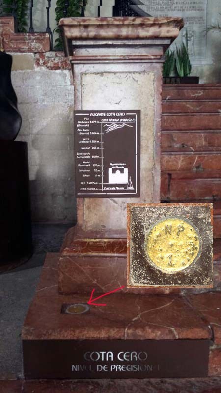
El NP 1 se representa por un clavo de bronce que indica el "datum altimétrico" o cota cero. Todas las altitudes de España se miden desde este punto en la escalera del consistorio alicantino. Pero para ello hubo que establecer primero el desnivel con la referencia del puerto y esta operación dio como resultado una altitud de 3'4095 metros del nivel NP1 con respecto al Nivel Medio del Mar en Alicante (NMMA en topografía). Teniendo esto en cuenta para los cálculos de geógrafos y topógrafos, desde el clavo de bronce del ayuntamiento alicantino se empezaron a "trazar" las líneas de nivelación de precisión para todo el territorio español.
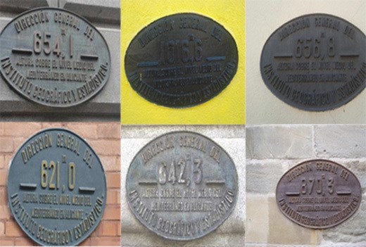
Toda España está llena de placas de altitud en las que se menciona a Alicante. La gran mayoría fueron colocadas a lo largo de 50 años, entre los 70 del siglo XIX y 1925. Probablemente estamos ante la primera campaña de márketing de Alicante a escala nacional. El nombre de la ciudad figura en muchos lugares visibles de España desde hace décadas y todo costeado por el Estado a través del Instituto Geográfico, organismo que ya no se ocupa de la conservación de los clavos de nivelación y las placas de altitud. De los primeros, muchos han desaparecido o quedado sepultados por las remodelaciones efectuadas con el paso de los años en estaciones y edificios. Las placas, que son la "propaganda" de Alicante, perviven mejor y en mayor cantidad.
Atención el ayuntamiento no está permanentemente abierto su horario de visitas es:
De lunes a viernes: De 9.00h a 14.00h.
Para dar por encontrado este cache virtual y poderlo registrar:
Deberás hacer una foto tuya o de tu equipo en el escalón del ayuntamiento.
También será válida una foto de tu GPS en las coordenadas del escalón donde aparezcan las coordenadas aproximadas de este punto o una foto de tu GPS en el escalón.
En el caso de encontrarse cerrado también será valida una foto en las escaleras de la reina en las coordenadas.
N 38º 20.618W 000º 28.842
Este caché virtual es parte de una versión limitada de Virtuals creada entre el 24 de agosto de 2017 y el 24 de agosto de 2018. Solo 4,000 propietarios de caché tuvieron la oportunidad de ocultar un caché virtual. Obtenga más información sobre Recompensas virtuales en el blog de Geocaching
 Translated with "Automatic translator" sorry for translation errors.
Why Alicante was chosen as a measurement level in altitude with respect to the sea of all Spain.
It was the year of 1856 (there were still two left for the arrival of the railway to Alicante) when the government of His Majesty Isabel II of Spain decided the creation of the Geographical and Statistical Institute. Which was to create topographic map of Spain and establish the altitude of cities and landforms with respect to the lowest levels of its soil, This is where Alicante enters.
Why was our city chosen? A stable climate and its situation in the Mediterranean with respect to the Peninsula, make it possible that this enclave is more protected than other coastal cities in Spain such as the Bay of Biscay and the Atlantic discarded by having variations of more than 4 meters, while in Alicante the annual variation does not exceed 20 cm. A definitive factor to choose the place.
In addition, Madrid was close, which -logistically- was also another point in favor for Alicante.
So, decided the site had to get down to work with the necessary tools to build a modern and reliable topographic map of Spain having as point of origin, as Cota Cero, the city of Alicante. Here the first tide gauge of Spain was installed.
This photo is a Thomson tide gauge of 1926 that was installed in the port of Alicante. For decades, it fulfilled its function of measuring the variation in level experienced by the surface of the sea, considering it as a sheet of water free of waves. That is why these devices are located inside the port docks. Today it is exhibited in the Museum of the Astronomical Observatory of Madrid.
For three and a half years - from July 1870 to February 1874 - four daily measurements of sea level were made on a fixed metal ruler located at the beginning of the Levante dock, specifically on the popular stairways of the queen. At 9, 12, 15 and 18 hours.
Currently, a plaque placed by the current Ministry of Development recalls the place where these measurements were made that allowed to establish the zero altitude, the level zero, in Alicante.
What comes to indicate this plate located on the stairs of the queen is that this is the true zero level of altitude above sea level, although all measurements are made from the town hall, taking it as the level zero.
Once compiled the data that the tide gauge had collected for more than 3 years, a precision leveling was carried out by means of which the difference between the signal marked on the metallic rule of the port (the one on the stairway plate, the true level zero) and the first rung of the main staircase of the town hall that is, since then, the National Altimetric Reference, the Precision Level 1 (NP 1).
The NP 1 is represented by a bronze nail that indicates the "altimetric datum" or level zero. All the altitudes of Spain are measured from this point on the staircase of the town hall of Alicante. But for this it was necessary to first establish the slope with the reference of the port and this operation resulted in an altitude of 3'4095 meters of level NP1 with respect to the Average Level of the Sea in Alicante (NMMA in topography). Taking this into account for the calculations of geographers and topographers, from the bronze nail of the Alicante City Council they began to "trace" the precision leveling lines for the whole Spanish territory.
All of Spain is full of altitude plates in which Alicante is mentioned. The great majority were placed over 50 years, between the 70s of the 19th century and 1925. We are probably facing the first marketing campaign in Alicante on a national scale. The name of the city appears in many visible places in Spain for decades and everything paid for by the State through the Geographical Institute, an organization that no longer deals with the conservation of leveling nails and altitude plates. Of the first, many have disappeared or been buried by the remodeling carried out over the years in stations and buildings. The plates, which are the "propaganda" of Alicante, survive better and in greater quantity.
Attention the city council is not permanently open its visiting schedule is:
Monday to Friday: 9am to 2pm.
To find this virtual cache and register it:
You should make a photo of yourself or your team on the steps of the town hall.
It will also be valid a photo of your GPS in the coordinates of the step where the approximate coordinates of this point or a photo of your GPS on the step appear.
In case of being closed also will be valid a photo in the stairs of the queen in the coordinates.
N 38º 20.618W 000º 28.842
This Virtual Cache is part of a limited release of Virtuals created between August 24, 2017 and August 24, 2018. Only 4,000 cache owners were given the opportunity to hide a Virtual Cache. Learn more about Virtual Rewards on the Geocaching Blog.