
The geology of the Aran Islands is the same as the Burren (coming from Irish "boireann", meaning "stony land"), an area of karstic limestone. At the end of the last Ice Age, the sea levels gradually rose by about 100m. This eventually separated the Aran Islands from the Burren. The following map (Fig.01) shows the most prominent geological features of the Burren region. You can also see, that the Cliffs of Moher mainly consist of sandstone or shale instead of the Burren's limestone which was formed about 10 million years earlier.
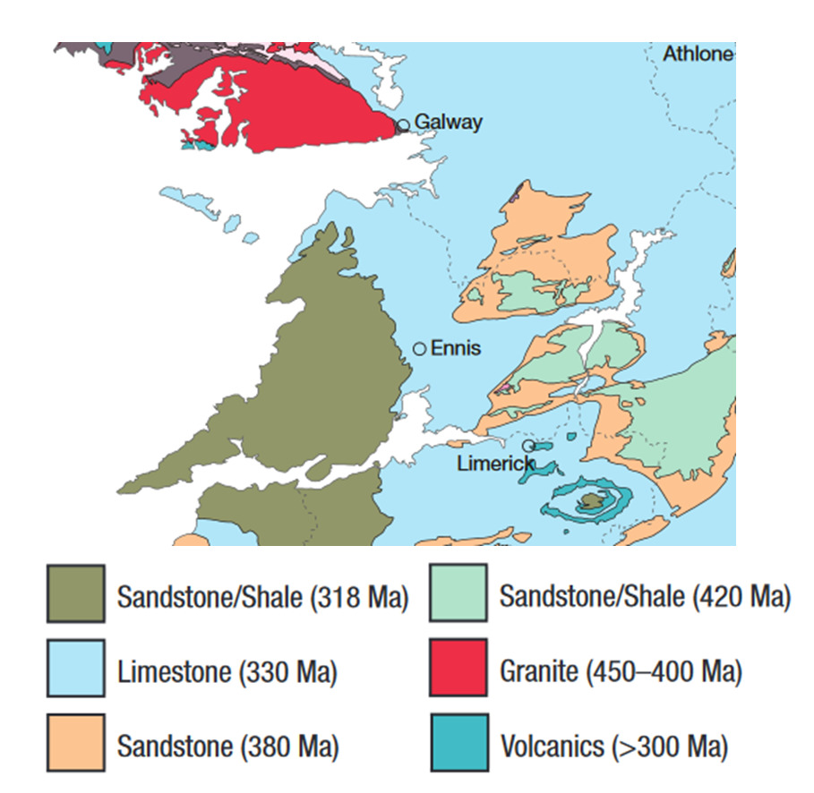
Fig.01: geological map of the Burren, reproduced from [1]
The Aran limestone differs from the granites and metamorphic rocks of Connemara. It is mainly composed of calcium carbonate and was formed by deposition of marine life forms approximately 350 million years ago. The limestone has been weathered into terraces (Fig.02), separated by fragile and softer layers of clay. The erosion is due to carbon dioxide in rain that makes the rain slightly acidic and subsequently leads to dissolution of the limestone.

Fig.02: limestone terrasses on Inis Mór.
The Aran Islands are one of the finest examples of a glaciokarst landscape in the world. Here, the the phenomenon is clearly visible as a pavement-like structured landscape (Fig.03). These limestone pavements are one of the classic glaciokarst landform and are typically horizontal or gently inclined surfaces of bare limestone dissected to varying extents by grykes and karren. They are formed by the action of ice sheets or glaciers, exposing subaerially fresh, unweathered surfaces of limestone. Limestone pavements are found only in areas that have been recently glaciated. Usually, this directed erosion leads to swallow holes, underground water flowssurfaces, and caves. Subsequently these caves may also collapse due to structual damage forming so-called dolins.

Fig.03: pavement structure on Inis Mór.
Grykes, clints, and karren.
Grykes are sub-vertical fissures in limestone pavement that develop via the widening of pre-existing fractures in the rock by dissolution. The blocks of limestone are separated by grykes are termed clints. Grykes and clints are very common on the limestone of the Burren region and are responsible for the pavement-like structure. Grykes can be up to 80 cm wide and up to 2 m in depth. Karren are mm- to m-sized features formed on the limestone surface by dissolutional carving and not erosion. They are classified according to their shape and size, with the most common forms including rillenkarren (small runnels) and rinnenkarren (larger runnels), which appear as "carving" at the edges of grykes and trittkarren (shallow sub-horizontal steps) that appear on the top of clints (Fig.04).

Fig.04: Examples of karren. Rinnenkarren (left) and shallow trittkarren (right).
Aran limestone holds many fossils including gastropods, corals, sea lilies, brachiopods and vertebrates, however, they are not part of this Earthcache, you'd have to visit GC5AFQY on Inis Oírr for that.
This Earthcache:
Now to the tasks that await you on this Earthcache.
There's no information board, so you'll have to perform some experiments by yourselves and solve the tasks together with the listing. Tools: measuring tape or meter stick.
You can reach the cache by hiking or biking, the distance to the cache from the pier is about 2 km. Head south and turn right at the trailhead. Follow the sign to Dún Aonghasa, after about 1.5 km you'll reach the site.
1. Near the posted coordinates coming from the harbour look at the left-hand side for the clint depicted on the picture "Task1". Standing in front of it, estimate its half-length in metres (indicated by red line).
Please stay on the trail and do not climb over the wall!

2. In which cardinal direction do most of the larger grykes point? What is the reason for that?
3. Do you notice any karren on the field in front of you? If yes, which types?
4. Please take a closer look at the stone-wall in front of you. You'll notice thinner layers, forming a "pancake"-like structure of the stones. Please measure the thickness of one of these "pancakes".
5. Look around. You'll see some larger boulders sitting on the fields. Where do you think they came from?
6. Update 12 June 2019: With the change in EarthCache-Guidelines from 11 June 2019, photos as proof of being actually on site are again allowed (same as the new Virtuals). Please take a photo of yourself on site.You don't have to be recognisable, e.g. a part of your body, the GPSr, or a personal item also fulfils this requirement.
After sending me the answers to the questions you may log directly. I will contact you, if something is not correct. Please provide cache name (and/or GC7BJD3) and all visiting group members in your answers.
Have fun on your (geological) treasure hunt!
Sources:
[1] http://www.geoneed.org/wp-content/uploads/downloads/2011/05/Burren_Geo_Guide_NEED.pdf /
[2] http://www.mayo-ireland.ie/en/around-mayo/aran-islands/aran-islands-geology.html
Photos (if not stated otherwise) were taken by myself.
back to top