Type of EarthCache: Engineering Geology
Introduction
CH-GM Road as in the title of this EarthCache is the abbreviation of Cameron Highlands-Gua Musang Road which is a newly constructed road between Cameron Highlands in Pahang and Gua Musang in Kelantan (Figure 1). The road crosses the so called Bentong-Raub Suture which here is at least 18 km wide (Tjia & Syed Sheikh, 1996).

Figure 1. Location of Rock Slope Stability: CH-GM Road EarthCache and geological map of Bentong-Raub
Suture (modified after Metcalfe, 2000). The newly constructed road is not shown in the map.
Geology of CH-GM Road in the Bentong-Raub Suture
The Bentong-Raub Suture (Figure 1) represents the Palaeo-Tethys (ancient ocean) in Peninsular Malaysia. It is a southwards extension of the Nan-Uttaradit and Sra Kaeo sutures of Thailand (Hutchison, 2009). The suture zone contains oceanic ribbon chert that has been dated by radiolarian ranging in age from Upper Devonian to Upper Permian (Metcalfe, 1999). Graptolites in the associated states of the Tuan Estate south of Karak are dated Lower Devonian (Jones, 1970). Limestone clasts in mélange are of Lower and Upper Permian age. The Palaeo-Tethys therefore opened in the Lower Devonian, caused by separation of Sibumasu from Gondwanaland, and closed in the Triassic, caused by the Indosinian orogenic collision with the Indochina Block that was earlier sutured to Eurasia.
The western margin of the CH-GM Road is of Main Range granite and the eastern margin of bedded chert. On the west, the granite injects into phyllite-schist, a common rock-type. Tjia and Syed Sheik (1996) have mapped several thick zones of tuffaceous olistostrome and mélange. There is a small serpentinite lens. From west to east, there are at least seven tectonic units. A complete unit comprises a systematic sequence of phyllite and schist, olistostrome with or without a massive mudstone interval, and bedded chert. These packages are stacked with a NW-SE strike with steep to moderate dips towards the NE.
Rock Slope Stability: CH-GM Road
At the EarthCache site, the CH-GM Road cuts across one of the olistostrome units in the Bentong-Raub Suture. Due to its nature of formation, this olistostrome unit is not stable. The road slope that cuts into this unit requires rock slope stabilisation and protection measures – the exercise of this EarthCache.
Rock Slope Stabilisation & Protection Measures
Rock slope stabilisation and protection measures are required to prevent or mitigate rocks falls from cut rock slopes (Bromhead, 1986; Franklin & Dusseault, 1989; Franklin & Dusseault, 1991).
Rock slope stabilisation measures (Figure 2 & 8) include:
1. Rock dowel
A rock dowel is a fully grouted (cemented) ribbed reinforcing bar installed in a drill hole.
2. Rock bolt
A rock bolt is a steel rod for stabilizing rock slopes. It transfers load from the unstable exterior, to the confined (and much stronger) interior of the rock mass (Figure 3).
3. Rock anchor
A rock anchor is a steel rod placed in a hole drilled in rock, held in position by grout (concrete) or mechanical means. In principle, it is the same as a rock bolt, but usually the rock anchor is more than 4 meters long (Figure 4).
4. Active wire netting
Active wire netting restrains rocks from detaching or falling from the rockface by the presence of steel wire netting which is secured tightly to the rockface, using rock bolts or anchors (Figure 5).
5. Shotcrete
Shotcrete is concrete conveyed through a hose and pneumatically projected at high velocity onto a rock surface to stabilize it (Figure 6).
6. Drainage
Water can be a major cause of rock instability. High water pressures contribute to instability by reducing the shear strength of joints. Therefore, drainage and dewatering can be the most direct and effective methods of stabilization. Weepholes, seen highlighting from a shotcrete surface, is a form of drainage (Figure 6). Surface drainage is an effective method to drain surface water from rock slope surfaces (Figure 7).

Figure 2. Rock slope stabilisation measures: rock dowel, rock bolt, rock anchor,
shotcrete, and drainage (Franklin & Dusseault, 1991).
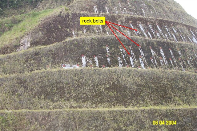
Figure 3. Rock bolts (Source: GC3T1WR).

Figure 4. Rock anchors (Source: GC3T1WR).

Figure 5. Active wire netting – wire netting & rock bolts (Source: GC3T1WR).

Figure 6. Shotcrete with weepholes (Source: GC3T1WR).

Figure 7. Surface drainage (Source: GC3T1WR).
Rock slope protection measures (Figure 8) include:
1. Passive wire netting
Passive wire netting allows rocks to detach from the rockface and fall, but is controlled by the steel wire netting drapery which encapsulates the debris. It is not to prevent rocks from falling but to guide falling rocks to fall into the trap ditch, to dissipate the kinetic energy of the falling rocks and to minimize bouncing (Figure 9).
2. Rock fall fence
Rock fall fence is either installed on the bench of a rock slope or at the foot of the rock slope to contain any rocks that fall from the rockface (Figure 10).
3. Rock trap ditch
Rock trap ditch is constructed at the base of a rock slope to capture fallen rock debris and confine them in the ditch.

Figure 8. Rock slope protection measures: passive wire netting, rock fall fences, and rock trap ditch. Active wire netting shown here is a rock slope stabilisation measure (modified from Bromhead, 1986).

Figure 9. Passive wire netting – wire netting without rock bolts.

Figure 10. Rock fall fence installed on the bench of a rock slope (Source: GC3T1WR).
How to claim this EarthCache?
1. Send an email with the text "CH - GM Road- Rock Slope Stability" on the first line, and include the answers to the following questions.
A. What are the rock slope stabilisation and protection measures used?
B. Are these measures effective? Explain why.
3. Log your find, sharing your experiences and photos (compulsory, to prove your visit).*
*Geocaching and Earth-caching are meant to be a fun family experience to introduce interesting and unique locations such as this one. It is not intended to be intimidating and your answers do not need to be 100% correct but we appreciate you at least putting in some effort with your answers, log and accompanying photos. Flexibility on logging requirements can only be applied if it can be established that you have actually taken the time to visit the site.
Glossary
1. Chert is a fine-grained silica-rich microcrystalline, cryptocrystalline or microfibrous sedimentary rock that may contain small fossils. It varies greatly in color (from white to black), but most often manifests as gray, brown, grayish brown and light green to rusty red; its color is an expression of trace elements present in the rock, and both red and green are most often related to traces of iron (in its oxidized and reduced forms respectively) (Wikipedia, 2012a).
2. Graptolites are fossil colonial animals known chiefly from the Upper Cambrian through the Lower Carboniferous (Mississippian). The name graptolite comes from the Greek graptos, meaning "written", and lithos, meaning "rock", as many graptolite fossils resemble hieroglyphs written on the rock (Wikipedia, 2012b).
3. A mélange is a large-scale breccia, a mappable body of rock characterized by a lack of continuous bedding and the inclusion of fragments of rock of all sizes, contained in a fine-grained deformed matrix. The mélange typically consists of a jumble of large blocks of varied lithologies. Large-scale melanges formed in active continental margin settings generally consist of altered oceanic crustal material and blocks of continental slope sediments in a sheared mudstone matrix. The mixing mechanisms in such settings may include tectonic shearing forces, ductile flow of a water-charged or deformable matrix (such as serpentinite), sedimentary action (such as slumping, gravity-flow, and olistostromal action), or some combination of these. Some larger blocks of rock may be as much as 1 kilometre (0.62 mi) across. Smaller-scale localized mélanges may also occur in shear or fault zones, where coherent rock has been disrupted and mixed by shearing forces (Wikipedia, 2012c).
4. An olistostrome is a sedimentary deposit composed of a chaotic mass of heterogeneous material, such as blocks and mud, known as olistoliths, that accumulates as a semifluid body by submarine gravity sliding or slumping of the unconsolidated sediments. It is a mappable stratigraphic unit which lacks true bedding, but is intercalated amongst normal bedding sequences, as in the Tertiary basin of central Sicily. The term olistostrome is derived from the Greek olistomai (to slide) and stroma (accumulation). Olistostromes are mélanges formed by gravitational sliding under water and accumulation of flow as a semi fluid body with no bedding (Wikipedia, 2012d).
5. Phyllite is a type of foliated metamorphic rock primarily composed of quartz, sericite mica, and chlorite; the rock represents a gradation in the degree of metamorphism between slate and mica schist. Minute crystals of graphite, sericite, or chlorite impart a silky, sometimes golden sheen to the surfaces of cleavage (or schistosity). Phyllite is formed from the continued metamorphism of slate (Wikipedia, 2012e).
6. Schists constitute a group of medium-grade metamorphic rocks, chiefly notable for the preponderance of lamellar minerals such as micas, chlorite, talc, hornblende, graphite, and others. Quartz often occurs in drawn-out grains to such an extent that a particular form called quartz schist is produced. By definition, schist contains more than 50% platy and elongated minerals, often finely interleaved with quartz and feldspar. Schist is often garnetiferous (Wikipedia, 2012f).
7. Serpentinite is a rock composed of one or more serpentine group minerals. Minerals in this group are formed by serpentinization, a hydration and metamorphic transformation of ultramafic rock from the Earth's mantle. The alteration is particularly important at the sea floor at tectonic plate boundaries (Wikipedia, 2012g).
8. In structural geology, a suture is a joining together along a major fault zone, of separate terranes, tectonic units that have different plate tectonic, metamorphic and paleogeographic histories. The suture is often represented on the surface by an orogen or mountain range. The term was borrowed from surgery where it describes the sewing together of two pieces of tissue. In plate tectonics, sutures are seen as the remains of subduction zones, and the terranes that are joined together are interpreted as fragments of different palaeocontinents or tectonic plates. Outcrops of sutures can vary in width from a few hundred meters to a couple of kilometers. They can be networks of mylonitic shear zones or brittle fault zones, but are usually both. Sutures are usually associated with igneous intrusions and tectonic lenses with varying kinds of lithologies from plutonic rocks to ophiolitic fragments (Wikipedia, 2012h).
9. Tuff (from the Italian tufo) is a type of rock consisting of consolidated volcanic ash ejected from vents during a volcanic eruption. Tuff is sometimes called tufa, particularly when used as construction material, although tufa also refers to a quite different rock. Rock that contains greater than 50% tuff is considered tuffaceous (Wikipedia, 2012i).
References
1 Bromhead, E.N., 1986. The Stability of Slopes. Surrey University Press, Glasgow, 374 pp. 2 Franklin, J.A. & Dusseault, M.B., 1989. Rock Engineering. McGraw-Hill Publishing Company, New York, 601 pp. 3 Franklin, J.A. & Dusseault, M.B., 1991. Rock Engineering Applications. McGraw-Hill Inc., New York, 433 pp. 4 Hutchison, C.S., 2009. Bentong-Raub Suture. In: Hutchison, C.S. & Tan, D.N.K. (eds.), 2009. Geology of Peninsular Malaysia. UM & GSM, Kuala Lumpur, Malaysia, pp 43-53. 5 Jones, C.R., 1970. On a Lower Devonian fauna from Pahang, West Malaysia. Geological Society of Malaysia Bulletin, 3, 63-75. 6 Metcalfe, I., 1999. The Palaeo-Tethys in East Asia. Geological Society of Malaysia Bulletin, 43, 131-143. 7 Metcalfe, I., 2000. The Bentong-Raub suture zone. Journal of Asian Earth Sciences, 18, 691-712. 8 Tjia, H.D. and Syed Sheikh Almashoor, 1996. The Bentong suture in southwest Kelantan, Peninsular Malaysia. Geological Society of Malaysia Bulletin, 39, 195-211. 9 Wikipedia, 2012a. Chert [online]. Available from http://en.wikipedia.org/wiki/Chert [accessed on 19 Aug 2012]. 10 Wikipedia, 2012b. Graptolithina [online]. Available from http://en.wikipedia.org/wiki/Graptolithinia [accessed on 19 Aug 2012]. 11 Wikipedia, 2012c. Mélange [online]. Available from http://en.wikipedia.org/wiki/ Mélange [accessed on 19 Aug 2012]. 12 Wikipedia, 2012d. Olistostrome [online]. Available from http://en.wikipedia.org/wiki/Olistostrome [accessed on 19 Aug 2012]. 13 Wikipedia, 2012e. Phyllite [online]. Available from http://en.wikipedia.org/wiki/Phyllite [accessed on 19 Aug 2012]. 14 Wikipedia, 2012f. Schist [online]. Available from http://en.wikipedia.org/wiki/Schist [accessed on 19 Aug 2012]. 15 Wikipedia, 2012g. Serpentinite [online]. Available from http://en.wikipedia.org/wiki/Serpentinite [accessed on 19 Aug 2012]. 16 Wikipedia, 2012h. Suture (geology) [online]. Available from http://en.wikipedia.org/wiki/Suture_(geology) [accessed on 19 Aug 2012]. 17 Wikipedia, 2012i. Tuff [online]. Available from http://en.wikipedia.org/wiki/Tuff [accessed on 19 Aug 2012].
Finding the answers to an EarthCache can often be challenging, and many people tend to shy away from these caches because of this. However, it is my opinion that geocaching is also meant to be a fun family experience that simply aims to introduce interesting and unique locations such as this one. Flexibility on logging requirements, however, can only be applied if it can be established that you have actually taken the time to visit the site. For this reason, a proper log describing your adventure accompanied by a good number of photos would be much appreciated.

Join us at Geocaching Malaysia