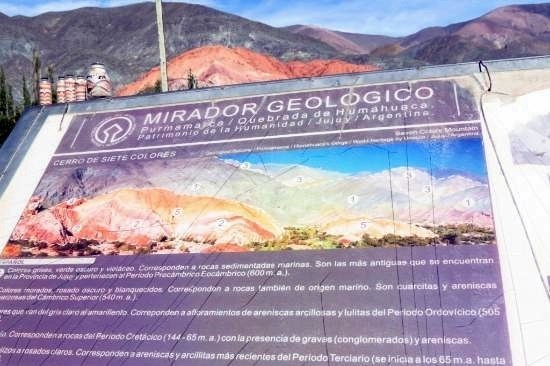
Es un afloramiento de rocas correspondientes a distintos tiempos, resultado de la interacción de grandes fuerzas en la corteza terrestre y los procesos erosivos. La variedad de colores es el producto de la acumulación de sedimentos en cuencas marinas y continentales desde hace 600 millones de años. El paisaje que hoy se observa no fue siempre el mismo, sino que es el resultado de una larga y compleja historia geológica.
Los colores grises, verde oscuro y violáceo son las rocas sedimentarias marinas más antiguas que se encuentran en la zona, correspondientes al Período Precámbrico-Eocámbrico (600 m.a.). Los colores morado violáceo, rosado oscuro y blanquecinos, también de origen marino, son cuarcitas y areniscas cuarzosas del Cámbrico Superior (540 m.a.), cuyos estratos albergan restos fósiles de la fauna de aquellos tiempos como, por ejemplo, los Skolithus (huella de gusanos cilíndricos) o los braquiópodos (moluscos bivalvos como las almejas). Y los colores que van del gris claro al amarillento son afloramientos de areniscas arcillosas y lutitas del Período Ordovícico (505 m.a.).
Despues de la primera etapa de sedimentación hubo un largo período de interrupción que continúa recién en el Cretácico (144-65 m.a.) con la presencia de gravas y areniscas de color rojo que corresponden a este período geológico. Mientras que los tonos rojizos a rosados claro son areniscas y arcillitas más recientes del Período Terciario (se inicia a los 65 m.a. hasta los 2,1 m.a.) durante el cual se define la actual cuenca continental.
El proceso culmina con el depósito de areniscas y gravas del Cuaternario (2,1 m.a.) especialmente en el fondo de valles y ríos. Más recientemente, la aparición del hombre en la región hace 10.000 años, comienza también a modelar cambios que concluyen en la conformación del paisaje natural-cultural actual.
English
It is an outcrop of rocks corresponding to different times, resulting from the interaction of large forces in the earth's crust and erosion processes. The variety of colors is the product of the accumulation of sediments in marine and continental basins for 600 million years. The landscape that is observed today was not always the same, but is the result of a long and complex geological history.
The gray, dark green and violet colors are the oldest marine sedimentary rocks found in the area, corresponding to the Precambrian-Eocambrian Period (600 m.y.). The purplish, dark pink and whitish colors, also of marine origin, are quartzites and quartz sandstones of the Upper Cambrian (540 m.y.), whose layers contain fossil remains of the fauna of those times, such as the Skolithus cylindrical) or brachiopods (bivalve molluscs such as clams). And the colors ranging from light gray to yellowish are outcrops of argillaceous sandstones and shales of the Ordovician Period (505 m.y.).
After the first stage of sedimentation there was a long interruption period that continues only in the Cretaceous (144-65 m.y.) with the presence of gravel and red sandstones corresponding to this geological period. While the rosy shades to light pink are the most recent sandstones and arcillites of the Tertiary Period (it starts at 65 m.y. to 2.1 m.y.) during which the current continental basin is defined.
The process culminates with the deposition of sandstones and gravels of the Quaternary (2.1 m.y.), especially in the bottom of valleys and rivers. More recently, the appearance of man in the region 10,000 years ago, also begins to model changes that conclude in the conformation of the current natural-cultural landscape.
Fuente: Javier Soto.
Requisitos del registro: Envíame tus respuestas por mensaje privado.
1. El suelo corresponde a un solo Período de tiempo? Nómbrelos.
2. El cerro está formado por capas de sedimentos que corresponden a distintos Períodos. Son de la misma Era Geológica? Nómbrelas.
3. El cerro se encuentra formado por distintas capas. Estas se encuentran apiladas unas sobre otras? o en ángulo?
4. Cuántos colores podemos encontrar? Todos del mismo Período?
5. Hacia qué punto cardinal mira el cerro?
Todos los registros fotográficos son bienvenidos.
Registry Requirements: Send me your answers by private message.
1. The soil corresponds to a single Period of time? Name them.
2. The hill is formed by layers of sediments that correspond to different Periods. Are they from the same Geological Age? Name them.
3. The hill is formed by different layers. Are these stacked on top of each other? or at an angle?
4. How many colors can we find? All from the same Period?
5. To what cardinal point does the hill look?
All photographic records are welcome.
 Bannercode:
<a href="https://coord.info/GC7CPP7" target="_blank"><img src="https://img.geocaching.com/cache/large/95c44a45-7557-4594-9ded-b01b0f573bb8.png?rnd=0.4545557" alt="Cerro Siete Colores" title="Cerro Siete Colores"></a>