St Austell Bay Geology - Folds at Fishing Point EarthCache
St Austell Bay Geology - Folds at Fishing Point
-
Difficulty:
-

-
Terrain:
-

Size:  (other)
Please note Use of geocaching.com services is subject to the terms and conditions
in our disclaimer.
This tide-dependent EarthCache is located on a publicly accessible beach at Fishing Point to the east of Carlyon Bay. Access to GZ is available via the South West Coast Path or over Carlyon Bay beach. Parking is available at Spit Beach (free at all times of the year but a longer walk) or Carlyon Bay where Seasonal Charges apply (see additional waypoints).
To avoid being cut off by the tide, or not being able to access GZ, you should plan to visit this EarthCache at Low Tide.
Tide times can be found here
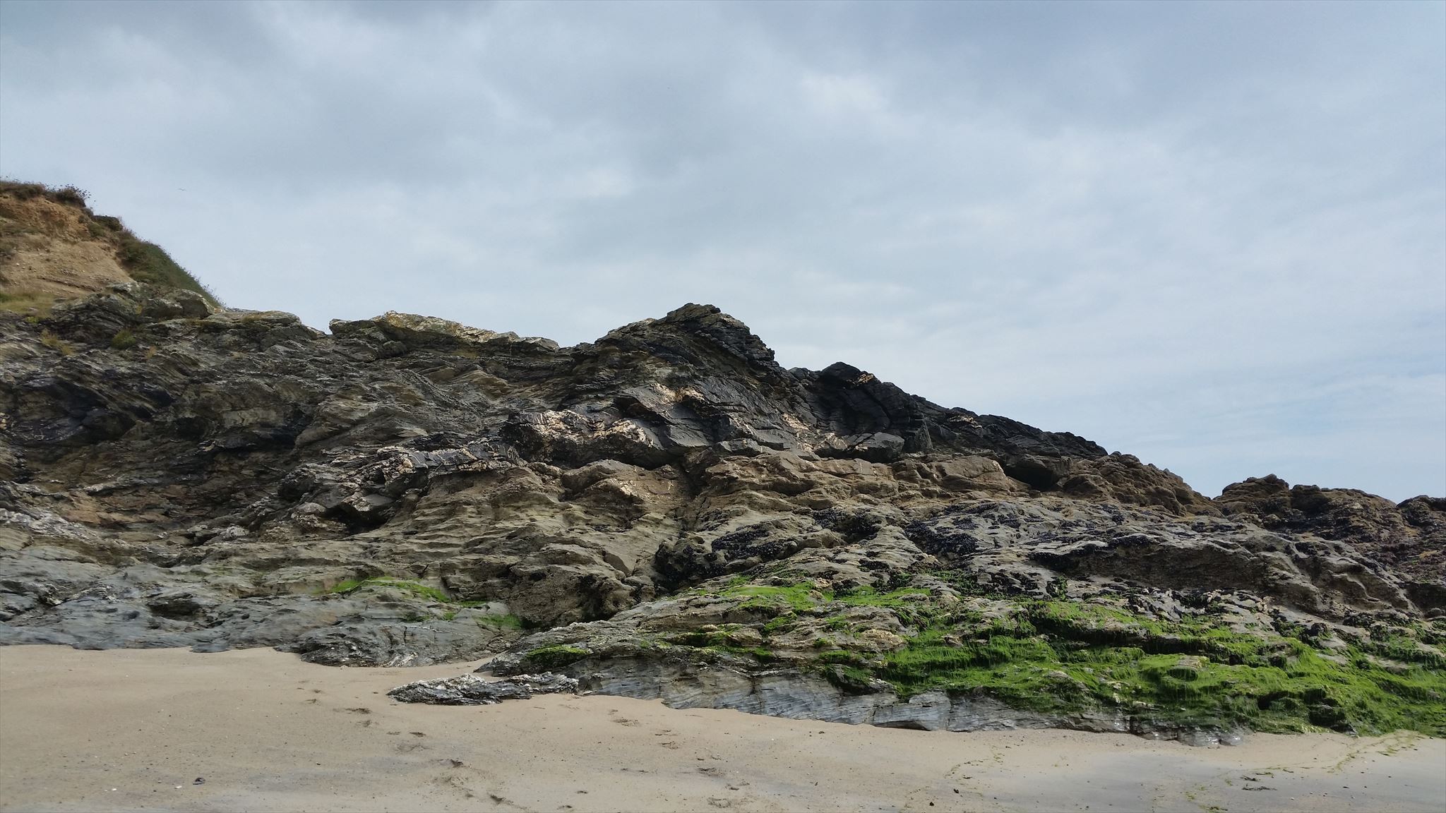 The outcrop that you are looking for
Most of the rock types exposed in St Austell Bay (including the ones at GZ) are metamorphosed sediments known as the Meadfoot Group and are named after Meadfoot Beach in Torquay, where the same rock types were first described in detail.
The Meadfoot Group is further sub-divided into 2 other Formations and the rocks in this bay belong to the Bovisand Formation. Comprising layers of mudstones, siltstones, some volcanics and limestone, these rocks were created under relatively shallow marine conditions around 400 million years ago during the Devonian Period. The layers contain lots of finely divided pyrite (iron sulphide) which gives them their dark-coloured appearance and also suggests that they were laid down under fairly anoxic (low oxygen) conditions. Following their deposition, the sediments were compressed, dewatered and subjected to a process called diagenesis which converted them to hard rock. Subsequent major Earth movements throughout Devonian and Carboniferous times affected much of SW England and caused the rocks in St Austell Bay to become folded, faulted and metamorphosed into rough heavily-fractured slates and sandstones, with abundant quartz-filled tension veins as shown below:
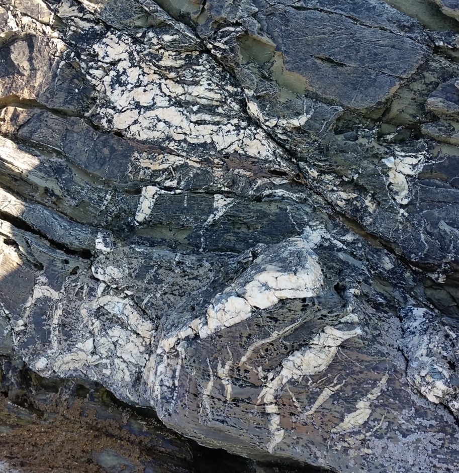 Quartz-filled tension veins
A weathering feature that can sometimes be observed in the rocks of St Austell Bay is called honeycomb weathering. Honeycomb weathering happens on rock surfaces exposed to salt. Salt gets deposited on the surface of the rock by saltwater or wind-blown spray. It then permeates the rock and as the water evaporates, the salt begins to crystallise within the pore-spaces of the rock. The growing salt crystals force apart the rock mineral grains, leaving the whole rock face vulnerable to other forms of weathering. Rocks that have suffered from honeycomb weathering have a very distinctive texture as shown below:
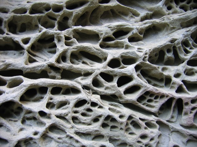 Honeycomb Weathering
The feature exposed at GZ and the main subject of the EarthCache is a distinctive fold.
A fold is a structure produced when an originally planar surface becomes bent or curved as a result of deformation.
Folds have a number of recognisable features as shown in the diagrams below:
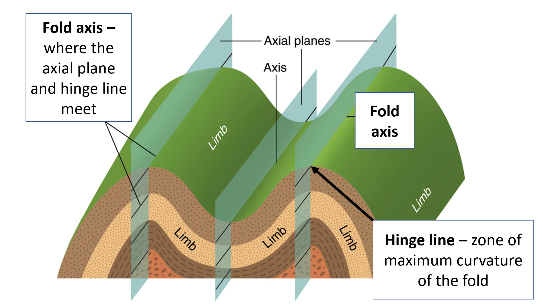 Fold Terminology
One way of classifying folds considers their tightness and the orientation of the axial plane. Fold tightness is the size of the angle between the fold's limbs as measured about the fold hinge. This is called the interlimb angle. Gentle folds have an interlimb angle of between 180° and 120°, open folds range from 120° to 70°, close folds from 70° to 30°, tight folds from 30° to 0° or isoclinal folds if the interlimb angle is 0° with roughly parallel limbs as shown below:
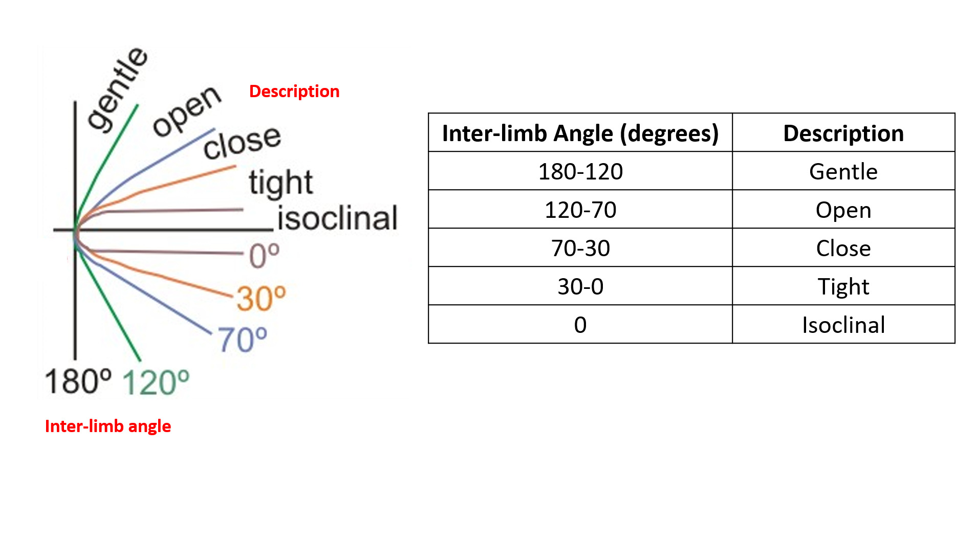 Interlimb Angle
The orientation of the axial plane relative to the horizontal together with the orientation of fold limbs allow subdivision into upright (axial plane vertical, limbs symmetric), overturned (axial plane moderately inclined, one limb overturned), or recumbent (axial plane near horizontal, one limb inverted) folds as shown below:
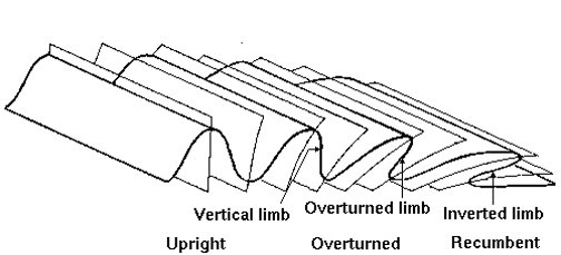 Axial Plane Orientation
In order to claim this EarthCache, go to the published coordinates - You should be standing in front of a large fold. It is easiest to see the fold whilst standing on the beach and looking at the rocky headland that sticks out into the sea.
Please message or email me your answers to the following questions through my profile at the top of this page or via this link:-
1) Observe the fold. Measure or estimate the interlimb angle and the orientation of the axial plane. Use the information provided in the description to suggest which type of fold it is. For instance - if you think the interlimb angle is 150° and the axial plane is vertical, then you would classify the fold as a gentle upright fold.
2) Find the prominent and well-exposed fold axis and measure or estimate the thickness of the seaward-facing bed. Do you think this bed is made from more resistant sandy-siltstone or less resistant mudstone? Explain your answer.
3) Observe the surface of the fold axis more closely. Describe its appearance and texture – Is it straight, curved, smooth or rippled? Can you see any other features visible on its surface? Describe what those features are and explain how they formed.
Feel free to log your find without having to wait for confirmation from me. However, if your answers are not correct or incomplete etc., I will contact you to verify your find.
Earthcache guidelines now make posting a photograph optional, but feel free to upload non-spoiler pics with your log if you wish.
Thanks for taking the time to visit this Earthcache and I hope you enjoy your visit.
Additional Hints
(Decrypt)
Ybbx sbe gur sbyq rkcbfrq va gur ebpxf ng Svfuvat Cbvag nf fubja va gur cubgbtencu bs gur bhgpebc va gur pnpur qrfpevcgvba.