
I calanchi (sing. calanco) sono un aspetto caratteristico del paesaggio sanmarinese.
Dal punto di vista geologico questo sito nacque durante il Pliocene, tra 5,3 e 2,5 milioni di anni fa. A quell’epoca qui si trovava un territorio costiero sul quale si accumulavano di continuo sedimenti argillosi e sabbiosi. I sedimenti formarono un suolo adatto, che costituisce una delle condizioni preliminari per il fenomeno dei calanchi. Questo processo è confermato tra l’altro dai ritrovamenti di fossili di invertebrati.
A San Marino per i calanchi è stato adottato per legge un piano organico generale di ripristino della vegetazione per i terreni calcarei. Al momento in cui è stata presentata la legge la superficie di territorio costituita da suoli argillosi interessati da fenomeni idrogeologici era il 20% della superficie totale e aumentava di anno in anno.
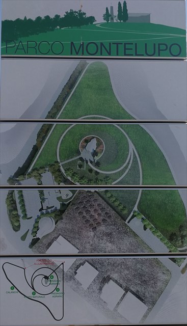
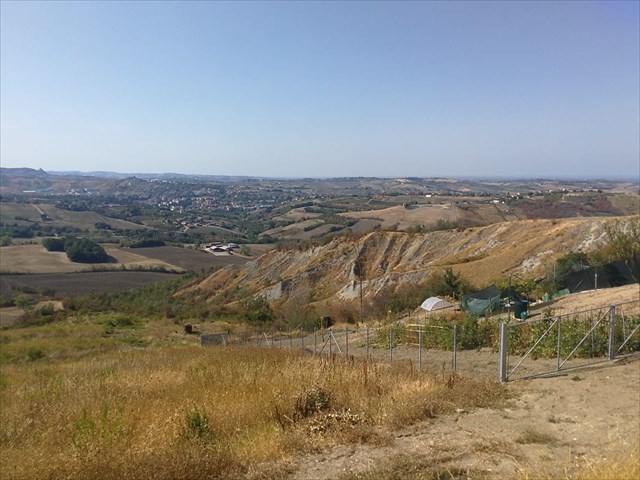
Seguendo le coordinate dell’header possiamo osservare uno degli ultimi calanchi della Repubblica che presentano ancora i caratteri morfologici originari. La posizione privilegiata del parco permette di godere della vista della valle calanchiva del Rio Fiumicello, che si sviluppa in direzione di Domagnano.
Il parco è stato istituito su richiesta degli abitanti di Torraccia. Si tratta di un sito caratterizzato dal paesaggio e dall’unicità storica e culturale. Il parco è circondato da alberi e arbusti per renderne la fruizione più piacevole nelle varie stagioni e mitigare il contrasto tra le aree edificate e il paesaggio.
Come nasce allora questa particolarità geologica, cioè i calanchi?
Un aspetto tipico dei calanchi è l’erosione continua del suolo. Questa ha cause riconducibili sia al diboscamento avvenuto in passato che al continuo essiccamento e dilavamento del suolo argilloso. Per la formazione dei calanchi sono necessarie cioè alcune importanti condizioni preliminari:
- suolo costituito in prevalenza da argilla con una componente sabbiosa compresa tra il 6% e il 18%
- precipitazioni intense
- orientamento del suolo di preferenza verso sud
- clima caratterizzato da precipitazioni intense alternate a lunghi periodi secchi
Il suolo argilloso è secco e granuloso, con fenditure e crepe sulla superficie. Quando è completamente bagnato diventa plastico. I minerali in esso contenuti hanno poche sostanze nutritive utili per la vegetazione, che può attecchire solo a fatica. Cadendo sul suolo argilloso le gocce d’acqua portate dalle piogge intense causano la dissoluzione delle piccole particelle di argilla; l’acqua scorre rapidamente lungo la superficie e nelle fenditure del terreno, portando con sé le particelle di argilla e formando dei solchi. Questi si allargano sempre più e creano con il tempo una fitta rete di canali in miniatura, il cui ulteriore ingrossamento ha come conseguenza finale la formazione di solchi su tutto il pendio ripido. Le particelle di argilla piccole e leggere che vengono dilavate si accumulano alla base del calanco e vengono trasportate fino al mare dai corsi d’acqua. Sulla parte superiore del calanco il terreno è particolarmente instabile per le forti precipitazioni. Dal pendio ripido si staccano continuamente piccole frane che causano la progressiva estensione del calanco fino alla cima della collina.
Questa particolarità geologica si può ammirare anche in molte altre zone d’Italia.
Fonti: geodz.com, pannelli informativi sul posto, fotografie proprie
E ora le domande:
- Descrivi con parole tue il processo geologico di formazione di un calanco. Come si presentano la superficie e la forma del terreno?
- Scrivimi in quale direzione il terreno scivola in basso e perché, secondo te, si verifica questo fenomeno.
- Scrivimi la data in cui si è riusciti a ottenere una legge per il piano di ripristino della vegetazione (header coordinates)
Sarebbe bello anche avere una foto dell’header tuo o del tuo GPS, ma non è obbligatorio
Invia le tue risposte sul mio GC-Account. Appena hai finito puoi effettuare immediatamente il log. Non devi attendere il mio permesso per effettuare il log. Se ci dovessero essere degli errori mi farò vivo.
Passate una bella giornata e divertitevi
Ed 

Calanco (pl. Calanchi) are one special feature of San Marino`s landscape.
From the geological point of view this place was formed approximately 5,3 to 2,5 million years ago in the era of Pliozän. Loam and sand sediments accumulated at the former coastal area. These sediments created appropriate ground, which was one of the requirements for the Calanchi phenomenon. Fossiles of invertebrates are additional proof of that.
A universally organic cultivation plan for loamy areas had been established by law in San Marino for the Calanchi. At the time of the establishment of this law the areas consisting of loam and affected by hydrogeolocical influence were about 20% of the total area and they are still growing every year!
At the header coordinates we can see one of the last existing Calanco of the republic, which still shows its typical morphological features. The park`s perfect location allows an overview of the Calanco valley of the river Fiumicello, which reaches out in the direction of Domagnano.
The park was established at the request of the inhabitants of Torraccia. A village famous for its landscape und its historical and cultural uniqueness. The park`s area is surrounded by trees and bushes to provide positive experience at any time of the year and also minimize the contrast between the constructed area and the landscape.
But how does this geological exception come into being - Calanchi?
Typical for the Calanchi is progressing soil erosion. This is due to both deforestation in the past and permanent eluviation of the loamy soil. The formation of a Calanco demands some important requirements:
- soil which consists mainly of loam with 6-18% sand fraction
- steep declivity
- some preferably south-facing location
- climate with the characteristics of heavy rains and long periods of dryness
Loamy ground is dry and powdery with crevices and fissures at its surface. If wet it is easily malleable. The existing minerals contain only few nutrients for plants, which find it hard to grow on it. If the loamy soil ist dry, waterdrops of heavy rains cause the replacement of small particles of loam; the water quickly disappears from the surface and the crevices, takes the particles with it and in this way builds watter gutters. They are getting broader and deeper and with time form a kind of dense miniature channel system, whose further magnification cause furrowing of the complete escarpment in the end. The small light and washed out particles of loam accumulate at the foot of the Calanco and are carried to the sea by the watercourses. Because of the strong gradient the Calanco`s upper part is quite unstable. Small landslides are constantly breaking out of the escarpment and cause gradually advancing expansion of the Calanco - up to the top of the hill.
These geological peculiarities can also be admired in many parts of Italy.
Sources: geodz.com, information boards, private photographs
Now the questions:
- Describe in your own words the geological exposure of the Calanco. What does the surface and form of the terrain look like?
- Tell me in which direction the terrain is descending and why you think this is?
- Tell me the date of the establishment of the law for the reclamation plan (header coordinates)?
A photo at the header coordinates of yourself or your GPS would be nice, but is optional!
Please send your answers to my GC-Account. Then you can log immediately, I will contact you if there are any problems with your answers.
I wish you a nice day and lots of fun!
Ed

Calanco (Mz: Calanchi) sind ein besonderes Merkmal der San Marinischen Landschaft.
Aus geologischer Sicht entstand dieser Ort während des Pliozäns vor etwa 5,3 bis 2,5 Millionen Jahren. Lehm- und Sand-Sedimente wurden im damaligen Küstengebiet angesammelt. Diese Sedimente schufen einen geeigneten Boden, der eine der Voraussetzungen des Calanchi-Phänomens ist. Dies wird zusätzlich durch die Fossilien von wirbellosen Tieren bestätigt.
In San Marino wurde für die Calanchi ein allgemeiner organischer Rekultivierungsplan für kalkhaltige Flächen per Gesetz erlassen. Zum Zeitpunkt der Einreichung des Gesetztes betrug die Fläche des Bodens, die aus Lehmböden bestand, die durch hydrogeologisches Einwirken betroffen waren, 20% der Gesamtfläche und es wird von Jahr zu Jahr mehr Fläche!
Bei den Headerkoordinaten können wir eines der letzten in der Republik vorhandenen Calanco sehen, das noch seine typischen morphologischen Eigenschaften besitzt. Die privilegierte Lage des Parks ermöglicht einen Überblick über das Calanco-Tal des Rio Fiumicello, das sich in Richtung Domagnano entwickelt.
Der Park wurde auf Wunsch der Einwohner von Torraccia errichtet. Ein Ort der durch seine Landschaft und historisch-kulturelle Einzigartigkeit gekennzeichnet ist. Das Gelände des Parks ist von Bäumen und Sträuchern umgeben, um den Genuss in den verschiedenen Jahreszeiten angenehmer zu gestalten und den Kontrast zwischen bebauter Fläche und Landschaft zu dämpfen.
Wie entsteht nun diese geologische Besonderheit - Calanchi?
Für die Calanchi typisch ist die fortschreitende Bodenerosion. Diese ist sowohl durch Abholzung des Waldes in der Vergangenheit zurückzuführen als auch auf die ständige Austrocknung und Auswaschung des Lehmbodens. Für die Entstehung eines Calanco bedarf es nämlich einiger wichtiger Voraussetzungen:
- ein vorwiegend aus Lehm bestehender Boden mit einer 6 - 18% Sandfraktion
- ein starkes Gefälle
- eine vorzugsweise nach Süden ausgerichtete Lage
- ein Klima, für das starke Regenfälle und lange Trockenperioden charakteristisch ist
Der Lehmboden ist trocken und pulverförmig, mit Spalten und Rissen an der Oberfläche. Wenn er durchnässt ist, wird er leicht formbar. Die vorhandenen Mineralien enthalten nur wenige Nährstoffe für die Pflanzen, die sich nur schwer auf ihm ansiedeln können. Auf einem trockenen Lehmboden verursachen die Wassertropfen eines heftigen Regens die Ablösung kleiner Lehmpartikel; das Wasser läuft schnell an der Oberfläche und in den Spalten ab, trägt die Lehmpartikel fort und bildet so Wasserrinnen. Diese werden immer breiter und tiefer und bilden mit der Zeit ein dichtes Kanalsystem in Miniaturformat, dessen weitere Vergrößerung schließlich die Zerfurchung des ganzen Steilhangs zur Folge hat. Die kleinen und leichten ausgewaschenen Lehmpartikel sammeln sich am Fuß des Calanco an und werden von den Wasserläufen bis ins Meer getragen. Im oberen Teil des Calanco ist das Gelände durch das starke Gefälle sehr instabil. Kleine Erdrutsche lösen sich ständig vom Steilhang ab und verursachen eine allmählich fortschreitende Ausbreitung des Calanco bis an die Spitze des Hügels.
Diese geologische Besonderheit, kann man auch in vielen Gegenden von Italien bewundern.
Quellen: geodz.com, Infotafeln vor Ort, eigene Bilder
Nun zu den Fragen:
- Beschreibe mit eigenen Worten den geologischen Aufschluss des Calanco? Wie sieht die Oberfläche und Form des Geländes aus?
- Schreib mir in welche Richtung das Gelände abfällt und warum es deiner Meinung so ist?
- Teile mir das Datum mit, wann das Gesetzes für den Rekultivierungsplan erwirkt wurde (Headerkoords)
Ein Foto beim Header von dir oder deinem GPS wäre nett, ist aber optional
Sende mir deine Antworten über meinen GC-Account. Danach kannst du sofort loggen. Du brauchst meine Logerlaubnis nicht abzuwarten! Wenn etwas falsch sein sollte, melde ich mich bei dir.
Einen schönen Tag und viel Spaß wünscht Euch
Ed