ITALIANO
Sardegna - un microcontinente
Gli amici delle geoscienze troveranno il loro valore: la Sardegna è come un piccolo continente, cioè si trovano rocce di quasi tutte le epoche geologiche. Dai depositi più piccoli, come le terrazze interglaciali sulla spiaggia, alle rocce calcaree e ardesie del Cambriano, si può trovare tutto.
Contesto geografico
La Sardegna ha visto geologicamente i suoi tempi più tormentati alle spalle. Durante la formazione ercinica della montagna con ripiegamento dei sedimenti paleozoici e massicce intrusioni di granito (batholit sardo) si sviluppò un paesaggio montuoso analogo alle Alpi, che fu esposto a lungo agli agenti atmosferici e all' erosione.
Con il periodo mesozoico, la massa terrestre con i resti di montagna appiattiti è stata abbassata e sollevata alternativamente e abbassata. Durante il Triassico e il Giurassico, alcune parti dell' isola (soprattutto il nord e l' est) sono state inondate da acque poco profonde e sono stati depositati sedimenti calcarei. La situazione era simile all' inizio del gesso. Alla fine del gesso inferiore si è avuta una marcata riduzione delle inondazioni, provocando erosione, in parte causata dall' erosione. l' intero deposito di pastello inferiore. Nel Cretaceo superiore c' era un altro avanzamento del mare dove ancora sedimenti calcarei sono stati depositati. Dopo il Cretaceo superiore, si formarono delle flotte a seguito di movimenti montani, alcuni dei quali erano sono state sollevate o abbassate. Una struttura più grande divideva l' isola e si formò un grande fosso che fu inondato nel terziario da un mare tropicale. Ciò ha portato alla deposizione di potenti e ricchi fossili, potenti arenarie calcaree, particolarmente evidenti nella regione di Sassari.
Circa 11,5 milioni di anni fa, seguì la separazione della piastra sardo-corsicana dalla Francia e la successiva rotazione di 45° contro il continente italiano. Circa 6 milioni di anni fa, la stampa si è arrestata. Durante la rotazione la Sardegna era tettonicamente molto attiva e ai margini di numerose cave (es. il fosso centrale del Campidano) si è sviluppato un vulcanismo intenso, i cui ultimi affioramenti durarono fino all' anno 8000 a. C.
Oggi la Sardegna si è consolidata, cioè per il suo carattere di piastra rigida (microcontinente) l' isola stessa è sismica. Tuttavia, la piastra - o meglio la rotazione precedente - è causa di alcuni problemi. tremori devastanti nel centro Italia. La tensione dei bordi delle lastre compresse nell' Italia occidentale, che è stata accumulata durante la rotazione, viene ridotta.
La Sardegna presenta una struttura grossolana in una parte nord-occidentale dell' isola con ardesia paleozoica, seguita da un' area più ampia di calcare mesozoico nel sud. La parte orientale dell' isola è costituita da granito cristallino con graniti a nord e ardesia / gneiss a sud ed è sovrapposta nella parte centrale da rocce mesozoiche di ampia portata. Anche il sud-ovest (Iglesiente, Sulcis) è costituito da rocce metamorfiche. L' intera isola è divisa da un grande sistema di trincea N-S. Lungo la parte nord-occidentale dell' isola, sono state depositate potenti coperte vulcaniche che conferiscono alla parte nord-occidentale dell' isola un' immagine caratteristica su lunghe distanze (grande area Alghero-Bosa).
La Sardegna settentrionale è caratterizzata principalmente dalle seguenti formazioni:
ardesia Devonian nel nord-ovest. Da Stintino a sud fino a Porto Ferro, l' ardesia scura vi aspetta. Sono stati fortemente piegati durante la formazione variegata della montagna. Nella zona della costa occidentale vicino all' Argentiera, si è formata una mineralizzazione (piombo/zinco ad alto contenuto di argento).
Granito della Gallura: Ampiamente diffuso nel nord-est, ad est di Castesardo e coprendo la Costa Smeralda quasi fino a Olbia.
Triassico, Giurassico e Cretaceo: le rocce di queste unità si trovano quasi ovunque nella zona tra Alghero e Capo Caccia fino a nord di Porto Torres.
Il triassico è molto comune nel centro di Alghero (calcare di cozze Las Tronas), nell' area di Porto Ferro/Cala Viola (pietra arenaria costiera, Keuper interno + Muschelkalk) e al Monte Ferro vicino a Porto Torres (possibilità di successione triassica completa).
Il M. Doglia è costituito da una sequenza di un intero Giura di 500 m di spessore, mentre le montagne più piccole intorno al Monte Doglia sono in parte costituite dalle montagne più piccole. sono costituiti da Giura e Cretaceo superiore (ad es. Monte Alvaro). Il possente blocco di Capo Caccia, invece, è costituito da gesso superiore e inferiore.
Mentre i calcari giurassici, con poche eccezioni, sono molto poveri nei macrofossili o i fossili sono spesso "cotti" nei calcari per lo più duri, nei calcari calcarei ci sono spesso spugne e rudisti silicizzati (una forma di conchiglia a coppa) che si possono trovare isolati quando si trovano in parti marnose. I Rudisti formarono delle scogliere di piccole dimensioni (patch-reef) nel Mar Cretaceo superiore.
L' allagamento poco profondo del nord-ovest era interrotto da processi tettonici alla fine del gesso inferiore, il terreno si alzò così tanto che l' erosione e la carsizzazione potevano iniziare (i gia' depositati strati di gesso inferiore erano in alcuni luoghi erosi fino agli strati giuridici). A causa degli agenti atmosferici, si sono formati depositi di bauxite, nel Cretaceo superiore è stato di nuovo allagato nel nord-ovestardia, in modo che i depositi di bauxite sono stati coperti e sono stati conservati fino ad oggi.
Le rocce mesozoiche sono tettonicamente condizionate e suddivise in strutture fosso/orrido più grandi e molte piccole lastre che sembrano a mosaico. Nella maggior parte dei casi, nella maggior parte dei casi, si è verificato solo un lieve ribaltamento. Fanno eccezione i calcari triassici superiori di Alghero e Keuperdolomite/Mergel del Cala Viola e della baia di Lazzaretto. Alcuni di questi sono disponibili verticale e la marna mostrano un' intensa ruggine dovuta alla tettonica salina causata da Keupergypsum.
Rocce vulcaniche del Terziario: A sud e ad est di Alghero, Ignimbrite e basalto sono in attesa. Si tratta degli strati cespiti di un grande vulcano con numerosi crateri secondari e ciminiere, depositatisi così a caldo da essere in parte saldati insieme. A volte erano alternativamente sovrapposti da tufi meno solidi, in modo che si formava una sequenza alternata di 800 m di spessore, che veniva rimossa lentamente o velocemente a seconda dello strato. Così si è formato un paesaggio stratificato, che forma la costa tra Alghero e Bosa. Resistenza ad uno strato duro locale all' erosione, montagne tavolo formatosi come la M. Minerva. Nei tufi si trovano forme di erosione tipiche, che formano anche alcuni gruppi rocciosi ben noti.
Le cime degli ultimi vulcani dominano l' area intorno a Thiesi. La migliore vista della pianura vulcanica con i suoi coni è quella di Monte Cuccuruddu, che si affaccia sul paese di Cheremule.
Calcare terziario: Si trovano nei dintorni di Sassari e sono facilmente riconoscibili per il loro colore beige chiaro. Si tratta di sedimenti di un mare poco profondo, che ha allagato il nord-ovestardia nel periodo terziario e in parte allagato. baie nelle valli esistenti. Le rocce sono molto ricche di combustibili fossili, e in alcuni luoghi sono state conservate intere aiuole di ostriche (ad esempio lungo la strada che da Monteleone R. porta a Padria). Altri fossili includono varie cozze, lumache, parti di granchi, ricci di mare e resti vegetali. Nei dintorni settentrionali di Villanova, i giacimenti riempirono il rilievo erosivo degli Ignimbrite e furono parzialmente ricoperti da essi. in modo che qui la pietra arenaria calcarea e l' Ignimbrite possano avvenire in contatto diretto (es. presso la Table Mountain del paese di Monteleone Roccadoria)
Caratteristici sono anche i terrazzamenti quaternari della spiaggia del Tirreno nella zona di Alghero. Sono molto ben addestrati direttamente nell' area del centro di Alghero, dove sono in parte addestrati sulle successioni Triassico/Jura. Anche presso la spiaggia "La Bombarde" è possibile osservare molto bene il diverso allenamento. Alcuni di questi ultimi sono costituiti solo da cozze e lumache. La creazione delle terrazze è legata alle fluttuazioni del livello dell' acqua delle diverse età glaciali. Durante i periodi freddi il livello dell' acqua è sceso, durante i periodi caldi è salito e ha lasciato terrazze più alte (max. 10-12 m sopra l' attuale livello dell' acqua). Inoltre, sono state diluite anche aree più ampie (ad esempio Porto Ferro).
Mappa Geologica della Sardegna
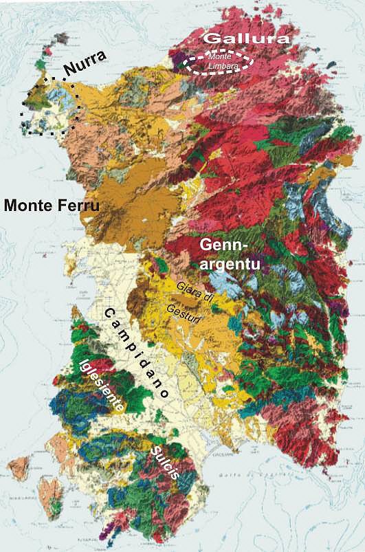
Leggenda della mappa:
Palaeozoico (totale nord-est che raggiunge sud-ovest e sud-ovest dell' isola, minore presenza nell' estremo nord-ovest)
rosso: invadente (granito, particolarmente diffuso nella Gallura, massiccio del Monte Limbara)
verde: Metamorfite
blu: sedimenti (deposito principale in Iglesiente e Sulcis)
Mesozoico (nella Nurra nella parte nord-occidentale e centrale della Sardegna orientale)
azzurro: Giurassico (Giura e Barbagia)
verde chiaro: gesso (essenzialmente Nurra, ad es. Capo Caccia, San Antioco)
marrone rossastro: vulcanite oligo-miocene (Ignimbrite, paesaggi stratificati a sud di Alghero e Sulcis)
marrone: Roccia erosiva, deposito principale Monte Ferru, Monte Arci.
arancio - giallo scuro: Oligo - sedimenti di pliocene (caratteristici per la zona intorno a Sassari, spigolo orientale di Campidano)
giallo pallido: quaternario (graben ripieno Campidano, terrazze sulla spiaggia)
Fonte: Mappa geologica della Regione Autonoma di Sardegna, rivista con dati SRTM.
Con questa Earthcache è possibile conoscere 3 tipi essenziali di roccia e le loro proprietà.
Al waypoint 1 si trova una scogliera calcarea. Il calcare è definito come roccia sedimentaria costituita principalmente dalla sostanza chimica carbonato di calcio (CaCO3) sotto forma di minerali calcite e aragonite.
La roccia calcarea è una roccia altamente variabile, che riguarda sia la sua origine che le sue proprietà, l' aspetto e la sostenibilità economica. Esiste quindi uno speciale campo di studio all' interno della geologia, la sedimentologia dei carbonati, che si occupa esclusivamente della formazione e delle proprietà dei diversi tipi di calcare. La maggior parte dei calcari sono di origine biogenica (formati da organismi viventi), ma vi sono anche calcari chimicamente precipitati e clastici.
Domanda 1: Quanto è alta la scogliera?
Domanda 2: Si tratta di calcare biogenico o clastico? Motivare la tua risposta.
Domanda 3: Prendete un pezzetto di pietra beige chiaro e gettatelo in un bicchiere di aceto. Cosa potete osservare?
Il punto 2 è la chiesa della Santissima Trinità di Saccargia. Oltre alla pietra calcarea sopra descritta, è stata costruita anche con basalto. Il basalto è una roccia di base (povera di SiO2) effusiva. Il basalto si forma durante lo scioglimento del manto terrestre, a bassa viscosità, il magma povero di SiO2 si raffredda sulla superficie terrestre o nell' oceano all' uscita, formando relativamente rapidamente la lava basaltica. Il magma ha generalmente temperature comprese tra 900 °C e 1200 °C, a seconda della composizione chimica. Il magma non è di solito liquido al 100 %, ma spesso vi sono inclusioni (Xenocryst) di minerali o rocce intere (Xenolith) con un punto di fusione più alto in esso, che sono stati trasportati lungo durante la salita. Basalto è di solito grigio scuro a nero. Essendo vulcanicamente formata, è costituita principalmente da un materiale di base a grana fine grazie al rapido raffreddamento. L' aspetto della lava basaltica fredda dipende principalmente da due fattori. Tuttavia, se il raffreddamento avviene con un ritardo, non è raro che le colonne angolari di basalto (colonna basalto) formino perpendicolarmente alla superficie di raffreddamento, preferibilmente con una geometria esagonale esagonale esagonale, come risultato della contrazione. Colonne di basalto di questo tipo si possono ammirare nel piccolo paese di Guspini in Sardegna, dove raggiungono un' altezza di 160 metri. Un' altra manifestazione è il basalto vescicolare, che si forma attraverso la formazione di piccoli fori e pori nella fase di degasaggio della fusione, che si solidificano come tale.
Domanda 4: Che tipo di basalto è stato usato per costruire la chiesa? Giustificare la risposta e descrivere la struttura dei moduli.
Domanda 5: Oltre al calcare e al basalto, è stata utilizzata un' altra pietra naturale. Che tipo di pietra naturale è? Quali sono i 3 elementi di questa roccia?
Ecco un' altra rappresentazione della geologia e delle formazioni rocciose della Sardegna:
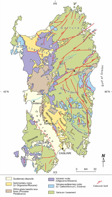
Fonte: http://www.tandfonline.com/doi/full/10.1080/17445647.2015.1084544
DEUTSCH
Sardinien – ein Mikrokontinent
Freunde der Geowissenschaften kommen auf ihre Kosten: Sardinien ist wie ein kleiner Kontinent, d.h. es kommen Gesteine fast aller Erdzeitalter vor. Von den jüngsten Ablagerungen wie z.B. den interglazialen Strandterrassen bis hin zu Kalken und Schiefern des Kambriums kann man alles finden.
Geologischer Werdegang
Sardinien hat geologisch gesehen seine unruhigsten Zeiten hinter sich. Bei der herzynischen Gebirgsbildung mit Faltung der paläozoischen Sedimente und gewaltigen Granitintrusionen (sardischer Batholit) entstand analog zu den Alpen eine Gebirgslandschaft, die dann lange Zeit der Verwitterung und Abtragung ausgesetzt war.
Mit dem Mesozoikum senkte sich die Landmasse mit den abgeflachten Gebirgsresten und wurde abwechselnd Hebung und Senkung ausgesetzt. In der Trias und im Jura wurden Teile der Insel (besonders der Norden und der Osten) von flacherem Wasser überflutet und es wurden überwiegend kalkige Sedimente abgelagert. Auch am Anfang der Kreide war die Situation ähnlich. Am Ende der Unterkreide gab es einen deutlichen Rückzug der Überflutung, es setze Erosion ein, die z.T. die gesamten Ablagerungen der Unterkreide abtrugen. In der Oberkreide gab es erneut einen Meeresvorstoß wobei erneut kalkige Sedimente abgelagert wurden. Nach der Oberkreide bildeten sich durch Gebirgsbewegungen Schollen, die z.T. angehoben oder abgesenkt wurden. Eine größere Struktur zerteilte die Insel und ein großer Graben bildete sich, der im Tertiär von einem tropischen Meer geflutet wurde. Dabei kam es zur Ablagerung fossilreicher mächtiger Kalksandsteine, die besonders auffällig im Raum Sassari ausgebildet sind.
Vor ca. 11,5 Millionen Jahren folgte die Abspaltung der sardisch-korsischen Platte von Frankreich und die nachfolgende Rotation um 45° gegen das italienische Festland. Vor ca. 6 Millionen Jahren kam die Rotation zum Stillstand. Während der Rotation war Sardinien tektonisch sehr aktiv und an den Rändern zahlreicher Brüche (z.B. der zentrale Campidano-Graben) entstand ein intensiver Vulkanismus, dessen allerletzte Ausläufer bis in das Jahr 8000 v. Christus andauerten.
Heute ist Sardinien konsolidiert, d.h. durch seinen Charakter als starre Platte (Mikrokontinent) ist die Insel selber erdbebensicher. Allerdings ist die Platte - oder vielmehr die ehemalige Rotation - Ursache für z.T. zerstörerische Beben in Mittelitalien. Dabei wird die Spannung der gestauchten Plattenränder im westlichen Italien wieder abgebaut, die sich während der Rotation aufbaute.
Auf die gesamte Insel bezogen, zeigt Sardinien einen grobgegliederten Aufbau in einen Nordwestlichen Teil mit paläozoischen Schiefern, dem im Süden ein größeres Gebiet mit mesozoischen Kalken folgt. Der östliche Teil der Insel besteht aus Kristallin mit Graniten im Norden und Schiefern/Gneisen im Süden und wird im mittleren Abschnitt von weit ausgedehnten mesozoischen Gesteinen überlagert. Der Südwesten (Iglesiente, Sulcis) besteht ebenfalls aus metamorphen Gesteinen. Die gesamte Insel ist durch ein großes N-S verlaufendes Grabensystem geteilt. Entlang diesem sind sehr mächtige vulkanische Decken abgelagert worden, die dem nordwestlichen Inselabschnitt über weite Strecken ein charakteristisches Bild verleihen (Großraum Alghero-Bosa).
Nordsardinien wird im Wesentlichen von den folgenden Formationen geprägt:
- Devonische Schiefer im Nordwesten. Von Stintino in Richtung Süden bis zum Porto Ferro stehen dunkle Schiefer an. Sie wurden während der varistischen Gebirgsbildung stark gefaltet. Im Bereich der westlichen Küste bei Argentiera kam es zur Ausbildung einer Vererzung (Blei / Zink mit hohem Silbergehalt).
- Granite der Gallura: Weit verbreitet im im Nordosten, östlich bei Castesardo anfangend und die gesamte Küste einehmend über die Costa Smeralda fast bis nach Olbia.
- Trias, Jura + Kreide: Fast in der ganzen Zone zwischen Alghero und dem Capo Caccia bis nördlich bei Porto Torres sind Gesteine dieser Einheiten zu finden.
Trias ist sehr verbreitet im Zentrum von Alghero (Muschelkalk von Las Tronas), im Bereich Porto Ferro/Cala Viola (Buntsandstein an der Küste, im Landesinneren Keuper + Muschelkalk) und am Monte Ferro bei Porto Torres (komplette Trias-Abfolge).
Der M. Doglia besteht ausschließlich aus einer kompletten 500 m mächtigen Juraabfolge, während die kleineren Berge rund um den Monte Doglia z.T. aus Jura und Oberkreide aufgebaut sind (z.B. Monte Alvaro). Dagegen ist der mächtige Block des Capo Caccia nur aus Unter + Oberkreide aufgebaut.
Während die Jurakalke bis auf einige Ausnahmen sehr arm an Makrofossilien sind oder die Fossilien oft in den meist harten Kalken "eingebacken" sind, gibt es in den Kreidekalken häufig verkieselte Schwämme und Rudisten (eine becherförmige Muschelform), die isoliert zu finden sind, wenn sie in mergeligen Partien vorkommen. Die Rudisten bildeten in den Oberkreidemeeren kleine Riffe (patch-reefs).
Die flache Überflutung von Nordwestsardinien wurde am Ende der Unterkreide durch tektonische Vorgänge unterbrochen, das Land hob sich so weit daß Erosion und Verkarstung einsetzen konnten (die schon abgelagerten Unterkreideschichten wurden stellenweise bis auf die Juraschichten abgetragen). Durch die Verwitterung bildeten sich Bauxitvorkommen, in der Oberkreide wurde Nordwestsardinien erneut überflutet wodurch die Bauxitvorkommen überdeckt wurden und bis heute erhalten geblieben sind.
Die mesozoischen Gesteine sind tektonisch bedingt in größere Graben/Horststrukturen und viele mosaikartig erscheinende Kleinschollen zerlegt. Dabei erfolgte meistens nur eine geringe Verkippung. Eine Ausnahme bilden die Obertriaskalke von Alghero und Keuperdolomite/Mergel der Cala Viola und an der Lazzaretto-Bucht. Diese stehen z.T. senkrecht und die Mergel weisen eine intensive Verfältelung auf, die auf Salztektonik durch Keupergips zurückzuführen ist.
- Vulkanische Gesteine des Tertiärs: Im Süden und Osten Algheros stehen Ignimbrite und Basalte an. Es handelt sich um die Tufflagen eines großen Vulkans mit mehreren Nebenkratern und Schloten, die so heiß abgelagert wurden, daß sie teilweise verschweißt wurden. Wechselweise wurden sie von weniger festen Tuffen überlagert, so daß eine 800m mächtige Wechselfolge entstand, die je nach Schicht langsam oder schneller wieder abgetragen wurde. So formte sich eine Schichtstufenlandschaft, die die Küste zwischen Alghero und Bosa prägt. Widerstand eine härte Schicht lokal der Erosion, bildeten sich Tafelberge wie der M. Minerva. In den Tuffen findet man typische Erosionsformen, die auch manche touristisch bekannte Felsgruppe bilden.
Kuppen der letzten Vulkane prägen die Umgebung von Thiesi. Den besten Ausblick über die Vulkanebene mit den Kegeln hat man von dem Monte Cuccuruddu, der die Ortschaft Cheremule überragt.
- Kalksteine des Tertiärs: Sie findet man in der Umgebung von Sassari und sind an ihrer hellbeigen Farbe leicht erkennbar. Es handelt sich um Ablagerungen eines flachen Meeres, das Nordwestsardinien im Tertiär überflutete und dabei z.T. Buchten in schon vorhandenen Tälern bildete. Die Gesteine sind sehr fossilreich, stellenweise sind komplette Austernbänke erhalten geblieben (z.B. an der Straße von Monteleone R. nach Padria). Weitere Fossilien sind diverse Muscheln, Schnecken, Teile von Krebsen, Seeigel und Pflanzenreste. In der nördlichen Umgebung von Villanova füllten die Ablagerungen das Erosionsrelief in den Ignimbriten aus und wurden stellenweise wieder von ihnen überdeckt. so daß hier Kalksandsteine und Ignimbrite in unmittelbarem Kontakt vorkommen können (z.B. am Tafelberg der Ortschaft Monteleone Roccadoria)
Charakteristisch sind auch die quartären Strandterrassen des Tyrrhen in der Umgebung von Alghero. Sie sind sehr auffällig direkt im Bereich des Zentrums von Alghero ausgebildet, wo sie z.T. über Trias/Jura-Abfolgen liegen. Auch am Strand "La Bombarde" kann sehr gut die unterschiedliche Ausbildung beobachtet werden. Teilweise bestehen Lagen nur aus Muschel/Schneckenschill. Die Entstehung der Terrassen ist mit den Wasserspiegelschwankungen der verschiedenen Eiszeiten verknüpft. Während der Kaltzeiten sank der Wasserspiegel, während der Warmzeiten stieg er und hinterließ höhere Terrassen (max. 10-12 m über dem heutigen Wasserspiegel). Zusätzlich kam es auch zur Verdünung größerer Areale (z.B. Porto Ferro).
Legende zur Karte:
Paläozoikum (gesamter Nordosten bis in den Süden reichend und Südwesten der Insel, kleineres Vorkommen im äussersten Nordwesten)
rot: intrusiv (Granit, besonders in der Gallura verbreitet, Monte Limbara Massiv)
grün: Metamorphit
blau: Sedimente (Hauptvorkommen im Iglesiente und Sulcis)
Mesozoikum (in der Nurra im Nordwesten und mittleren Abschnitt von Ostsardinien)
hellblau: Jura (Nurra und Barbagia)
hellgrün: Kreide (im wesentlichen Nurra, z.B. Capo Caccia, St. Antioco)
Känzoikum (ein breiter nordwestlich - südwestlich verlaufender Streifen, Campidano Graben und einzelne Vorkommen an der Ostküste)
rotbraun: oligo-miozäne Vulkanite (Ignimbrite, Schichtstufenlandschaften südlich von Alghero und im Sulcis)
braun: Erusivgesteine, Hauptvorkommen Monte Ferru, Monte Arci.
orange - dunkelgelb: Oligo - Pliozäne Sedimente (Charakteristisch für die Umgebung von Sassari, östlicher Rand des Campidano)
blassgelb: Quartär (Grabenfüllung Campidano, Strandterrassen)
Quelle: Geolgische Übersichtskarte der Regione Autonoma di Sardegna, überarbeitet mit SRTM Daten.
Mit diesem Earthcache könnt Ihr 3 wesentliche Gesteinsarten und deren Eigenschaften kennenlernen.
Am Wegpunkt 1 findet ihr eine Klippe aus Kalkstein. Als Kalkstein werden Sedimentgesteine bezeichnet, die überwiegend aus dem chemischen Stoff Calciumcarbonat (CaCO3) in Form der Mineralien Calcit und Aragonit bestehen.
Kalkstein ist ein äußerst variables Gestein; dies betrifft sowohl seine Entstehung als auch seine Eigenschaften, das Aussehen und die wirtschaftliche Verwendbarkeit. Es gibt daher innerhalb der Geologie eine eigene Fachrichtung, die Karbonatsedimentologie, die sich ausschließlich mit der Entstehung und den Eigenschaften der verschiedenen Kalksteintypen befasst. Die meisten Kalksteine sind biogener Herkunft (von Lebewesen gebildet), es gibt aber auch chemisch ausgefällte und klastische Kalksteine.
Frage 1: Wie hoch ist die Klippe?
Frage 2: Handelt es sich um biogenen oder klastischen Kalkstein? Begründe Deine Antwort.
Frage 3: Nimm ein kleines Bröckchen des hellbeigen Gesteins mit und werfe es in ein Glas mit Essig. Was kannst Du beobachten?
Wegpunkt 2 ist die Kirche Santissima Trinità di Saccargia. Neben dem oben bereits beschriebenen Kalkstein, wurde sie auch mit Basalt gebaut. Basalt ist ein basisches (SiO2-armes) Ergussgestein. Basalt entsteht bei der Aufschmelzung des Erdmantels, dünnflüssiges, SiO2-armes Magma erkaltet an der Erdoberfläche oder im Ozean beim Austritt relativ schnell zu Basaltlava. Die Magmen haben bei ihrem Austritt in der Regel Temperaturen zwischen 900 °C und 1200 °C, abhängig von ihrem Chemismus. Das Magma ist dabei in der Regel nicht zu 100 % flüssig, es befinden sich häufig auch Einschlüsse (Xenocryst) von Mineralen oder ganzen Gesteinen (Xenolith) mit einem höheren Schmelzpunkt darin, die beim Aufstieg mitgerissen wurden. Basalt ist für gewöhnlich dunkelgrau bis schwarz. Da er vulkanisch entsteht, besteht er aufgrund der schnellen Abkühlung zum größten Teil aus einer feinkörnigen Grundmasse. Die Erscheinungsform erkalteter basaltischer Lava ist hauptsächlich von zwei Faktoren abhängig. Eruptierte Lava kühlt recht schnell aus zu einem zusammenhängenden Gesteinsgefüge. Findet die Abkühlung jedoch verzögert statt, entstehen durch das Zusammenziehen nicht selten meterlange eckige Basaltsäulen (Säulenbasalt), die sich senkrecht zur Abkühlungsfläche bilden, bevorzugt mit einer hexagonalen(sechseckigen) Geometrie. Solche Basaltsäulen sind im Örtchen Guspini auf Sardinien zu bewundern und erreichen dort eine Höhe von 160 Metern. Eine andere Erscheinungsform nennt sich vesikulärer Basalt, der dadurch entsteht, dass in der Entgasungsphase der Schmelze kleine Löcher und Poren gebildet werden, die dann als solche erstarren.
Frage 4: Mit welcher Art von Basalt wurde die Kirche gebaut? Begründe Deine Antwort und beschreibe die Struktur der Baussteine.
Frage 5: Neben Kalkstein und Basalt wurde ein weiterer Naturstein verarbeitet. Um welchen Naturstein handelt es sich? Aus welchen 3 Bestandteilen besteht dieses Gestein üblicherweise?
Hier noch eine weitere Darstellung der Geologie und Gesteinsvorkommen von Sardinien:
Quelle: http://www.tandfonline.com/doi/full/10.1080/17445647.2015.1084544
ENGLISH
Sardinia - a microcontinent
Friends of geosciences will find their money's worth: Sardinia is like a small continent, i. e. rocks from almost all geological eras occur. From the youngest deposits such as interglacial terraces on the beach to limestone and slates of the Cambrian you can find everything.
Geological background
Sardinia has geologically seen its most troubled times behind it. During the Hercynian mountain formation with folding of the palaeozoic sediments and massive granite intrusions (Sardinian Batholit) a mountainous landscape developed analogously to the Alps, which was then exposed to weathering and erosion for a long time.
With the Mesozoic period, the land mass with the flattened mountain remnants was lowered and was alternately raised and lowered. In the Triassic and Jurassic periods, parts of the island (especially the north and east) were flooded by shallow water and calcareous sediments were deposited. The situation was similar at the beginning of the chalk. At the end of the lower chalk there was a marked reduction in flooding, causing erosion, some of which was caused by the erosion. the entire lower crayon deposits. In the upper Cretaceous there was another sea advance where again calcareous sediments were deposited. After the Upper Cretaceous, floes formed as a result of mountain movements, some of which were have been raised or lowered. A larger structure divided the island and a large ditch formed which was flooded in the tertiary by a tropical sea. This led to the deposition of fossil-rich, powerful limestone sandstones, which are particularly noticeable in the Sassari region.
About 11.5 million years ago, the separation of the Sardinian-Corsican plate from France followed and the subsequent rotation by 45° against the Italian mainland. About 6 million years ago, the press came to a standstill. During the rotation, Sardinia was tectonically very active and at the edges of numerous quarries (e. g. the central Campidano ditch) an intensive volcanism arose, whose very last outcrops lasted until the year 8000 BC.
Today Sardinia is consolidated, i. e. due to its character as a rigid plate (microcontinent) the island itself is earthquake-proof. However, the plate - or rather the former rotation - is the cause of some problems. devastating tremors in central Italy. The tension of the compressed plate edges in western Italy, which was built up during rotation, is reduced.
Sardinia shows a coarse structure in a north-western part of the island with paleozoic slate, followed by a larger area of Mesozoic limestone in the south. The eastern part of the island consists of crystalline granite with granites in the north and slate / gneiss in the south and is overlaid in the central section by far-reaching mesozoic rocks. The southwest (Iglesiente, Sulcis) also consists of metamorphic rocks. The entire island is divided by a large N-S trench system. Along the northwestern part of the island, very powerful volcanic blankets have been deposited, which give the northwestern part of the island a characteristic image over long distances (large Alghero-Bosa area).
Northern Sardinia is mainly characterized by the following formations:
Devonian slate in the northwest. From Stintino to the south to Porto Ferro, dark slate is waiting for you. They were strongly folded during the varistic mountain formation. In the area of the western coast near Argentiera, mineralization (lead / zinc with a high silver content) was formed.
Gallura granite: Widely spread in the northeast, east of Castesardo and covering the Costa Smeralda almost all the way to Olbia.
Triassic, Jurassic and Cretaceous: Rocks of these units can be found almost all along the zone between Alghero and Capo Caccia up to the north of Porto Torres.
Triassic is very common in the centre of Alghero (Las Tronas mussel limestone), in the area of Porto Ferro/Cala Viola (coastal sandstone, inland Keuper + shell limestone) and at Monte Ferro near Porto Torres (complete Triassic succession).
The M. Doglia consists of a complete 500 m thick Jura sequence, while the smaller mountains around Monte Doglia partly consist of the smaller mountains. are made up of Jura and Upper Cretaceous (e. g. Monte Alvaro). The mighty block of Capo Caccia, on the other hand, is made up of upper and Lower Cretaceous.
While Jurassic limestones, with a few exceptions, are very poor in macrofossils or the fossils are often "baked" in the mostly hard limestones, in Cretaceous limestone there are often silicified sponges and rudists (a cup-shaped shell form) which can be found isolated when they occur in marly parts. The Rudists formed small reefs (patch-reefs) in the upper Cretaceous Sea.
The shallow flooding of north-westardia was interrupted by tectonic processes at the end of the Lower Cretaceous, the land rose so far that erosion and karstification could begin (the already deposited Lower Cretaceous layers were in some places eroded down to the juridical layers). Due to the weathering, bauxite deposits formed, in the Upper Cretaceous was again flooded in northwestardia, so that the bauxite deposits were covered over and have been preserved to this day.
The mesozoic rocks are tectonically conditioned and broken down into larger ditch/horst structures and many small slabs appearing mosaic-like. In most cases, only a slight tilting took place. An exception are the Upper Triassic limestones of Alghero and Keuperdolomite/Mergel of the Cala Viola and at Lazzaretto Bay. Some of these are available vertical and the marl show an intensive wrinkling due to salt tectonics caused by Keupergypsum.
Volcanic rocks of the Tertiary: In the south and east of Alghero, Ignimbrite and basalt are waiting. These are the tufted layers of a large volcano with several secondary craters and chimneys, which have been so hotly deposited that they were partly welded together. They were alternately overlaid by less solid tuffs, so that an 800m thick alternating sequence was formed, which was removed slowly or faster depending on the layer. This is how a layered landscape was formed, which shapes the coast between Alghero and Bosa. Resistance a hard layer local to the erosion, table mountains formed like the M. Minerva. In the tuffs one finds typical erosion forms, which also form some well known rock groups.
The peaks of the last volcanoes dominate the area around Thiesi. The best view of the volcanic plain with its cones is from Monte Cuccuruddu, which overlooks the village of Cheremule.
Tertiary limestone: They can be found in the surroundings of Sassari and are easily recognizable by their light beige colour. These are sediments of a shallow sea, which flooded northwestardia in the tertiary period and partly flooded. bays in existing valleys. The rocks are very rich in fossil fuels, and complete oyster beds have been preserved in places (e. g. along the road from Monteleone R. to Padria). Other fossils include various mussels, snails, parts of crabs, sea urchins and plant remains. In the northern surroundings of Villanova, the deposits filled the erosion relief in the Ignimbrites and were partially covered by them again. so that here sand-lime bricks and Ignimbrite can occur in direct contact (e. g. at the Table Mountain of the village Monteleone Roccadoria)
The quaternary terraces of the Tyrrhen beach in the Alghero area are also characteristic. They are very conspicuously trained directly in the area of the centre of Alghero, where they are partly about Triassic/Jura successions. Also at the beach "La Bombarde" you can observe the different training very well. Some of the layers consist only of mussel/snail shill. The creation of the terraces is linked to the water level fluctuations of the different ice ages. During the cold times the water level dropped, during the warm periods it rose and left behind higher terraces (max. 10-12 m above today's water level). In addition, larger areas (e. g. Porto Ferro) were also diluted.
Geological Map of Sardinia
Map legend:
Palaeozoic (total northeast reaching southwest and southwest of the island, smaller occurrence in the extreme northwest)
red: intrusive (granite, especially widespread in the Gallura, Monte Limbara massif)
green: Metamorphite
blue: sediments (main deposit in Iglesiente and Sulcis)
Mesozoic (in the Nurra in the northwest and central section of Eastern Sardinia)
light blue: Jurassic (Jura and Barbagia)
light green: Limestone (essentially Nurra, e. g. Capo Caccia, St. Antioco)
Känzoikum (a broad northwest - southwest strip, Campidano ditch and single occurrences on the east coast)
reddish brown: oligo-miocene volcanites (Ignimbrite, layered landscapes south of Alghero and Sulcis)
brown: Erosive rock, main deposit Monte Ferru, Monte Arci.
orange - dark yellow: Oligo - Pliocene sediments (characteristic for the area around Sassari, eastern edge of Campidano)
pale yellow: quaternary (graben filling Campidano, beach terraces)
Source: Geological survey map of the Autonoma di Sardegna region, revised with SRTM data.
With this Earthcache you can get to know 3 essential rock types and their properties.
At waypoint 1 you will find a limestone cliff. Limestone is defined as sedimentary rocks consisting mainly of the chemical substance calcium carbonate (CaCO3) in the form of the minerals calcite and aragonite.
Limestone is a highly variable rock; this concerns both its origin and its properties, appearance and economic viability. There is therefore a special field of study within geology, carbonate sedimentology, which deals exclusively with the formation and properties of the different types of limestone. Most limestones are of biogenic origin (formed by living organisms), but there are also chemically precipitated and clastic limestones.
Question 1: How high is the cliff?
Question 2: Is it biogenic or clastic limestone? Reason your answer.
Question 3: Take a small piece of the light beige stone and throw it into a glass of vinegar. What can you observe?
Point 2 is the church of Santissima Trinità di Saccargia. In addition to the limestone described above, it was also built with basalt. Basalt is a basic (SiO2-poor) effusive rock. Basalt is formed during the melting of the Earth's mantle, low-viscosity, SiO2-poor magma cools down on the Earth's surface or in the ocean at the exit relatively quickly to form basalt lava. The magma usually have temperatures between 900 °C and 1200 °C, depending on their chemical composition. The magma is usually not 100 % liquid, but often there are inclusions (Xenocryst) of minerals or whole rocks (Xenolith) with a higher melting point in it, which were carried along during the ascent. Basalt is usually dark grey to black. Since it is volcanically formed, it consists mainly of a fine-grained base material due to the rapid cooling. The appearance of cold basaltic lava is mainly dependent on two factors. However, if the cooling takes place with a delay, it is not uncommon for metre-long angular basalt columns (column basalt) to form perpendicular to the cooling surface, preferably with a hexagonal hexagonal geometry, to form as a result of the contraction. Basalt columns of this kind can be admired in the small town of Guspini on Sardinia, where they reach a height of 160 metres. Another manifestation is vesicular basalt, which is formed by the formation of small holes and pores in the degassing phase of the melt, which then solidify as such.
Question 4: What kind of basalt was used to build the church? Justify your answer and describe the structure of the building blocks.
Question 5: In addition to limestone and basalt, another natural stone was used. What kind of natural stone is it? What are the 3 elements of this rock?
Here is another representation of the geology and rock formations of Sardinia:
Source: http://www.tandfonline.com/doi/full/10.1080/17445647.2015.1084544