Introduction
The waters that issue from the seeps and springs on the lower slopes of the eastern flank of Table Mountain have been used since pre-historical times. There are several historically important springs between Rondebosch and Kirstenbosch. Few people realise how these springs - geological features - have contributed in many ways to Cape Town's southern suburbs. The Kirstenbosch spring is both a practical and aesthetic asset to the botanical gardens.
Kirstenbosch Spring 2017
LOGGING REQUIREMENTS
TO CLAIM AND LOG A FIND FOR THIS EARTH CACHE YOU NEED TO ANSWER THE FOLLOWING QUESTIONS AND EMAIL YOUR ANSWERS VIA MY GEOCACHING PROFILE.
[Each member of a caching group must submit individual answers.]
ONCE YOU HAVE VISITED THE SITE AND ARE CONFIDENT THAT YOUR ANSWERS ARE CORRECT YOU MAY LOG THE SITE AS "FOUND". IF THE ANSWERS ARE NOT RECEIVED, OR IF ANSWERS ARE NOT ADEQUATE TO VALIDATE YOUR FOUND LOG
THE LOG MAY BE DELETED.
1. Is the water from the Kistenbosch spring more or less acid than the water from the Newlands, Albion, and Kommetjie springs?
2. Provide a brief explanation of why the Kirstenbosch spring water has slightly different chemical properties to the water from the springs further north.
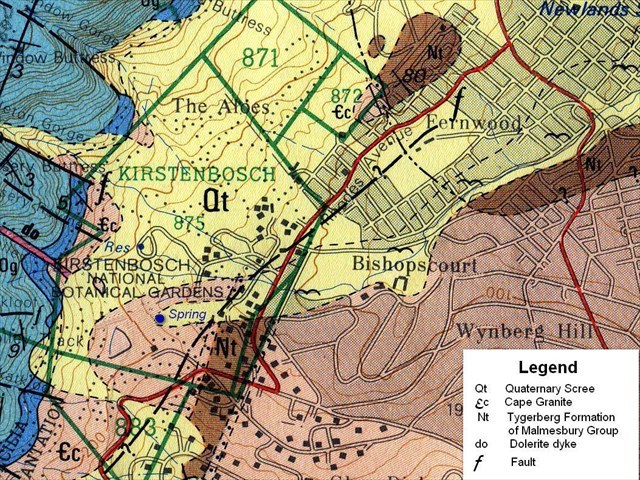
3. To what formations do the symbols Qt; Ec; Nt; and do; on the geology map refer?
4. Look carefully at the geological map provided in the cache write-up.
If the map supports what is written in the write-up answer CACHE CORRECT
If the map supports the information board which states that the spring is related to a fault in Skeleton Gorge answer BOARD CORRECT
The Springs of the Southern Suburbs
The waters that issue from the seeps and springs on the lower slopes of the eastern flank of Table Mountain have been used since pre-historical times. Stone tools and hand-axes found close to the Kirstenbosch spring establish this. There are 18 recognised springs between Rondebosch and Kirstenbosch. Few people realise how these springs - geological features - have contributed in many ways to the development of Cape Town's southern suburbs and still play a significant role. The earth caches: Albion Spring (GC7DNQJ); The Newlands Springs (GC7DQOY); and Kommetjie Spring (GC7DTJ7); provide additional information on different aspects of the hydrogeology and historical importance of these springs.
Kirstenbosch Spring
and the National Botanical Gardens
The farm Kirstenbosch has had a chequered history. Oringinally named Leendertsbos after a woodcutter named Leendert Cornelissen, who in 1657 was granted the right to cut timber here by Van Riebeeck. In 1659 it is recorded in Van Riebeeck's diary that Leendert Cornelissen received an assegai wound when KHoi Khoi from Hout Bay attacked him and his slaves. This attach led to Van Riebeeck ordering that a barrier of indigenous bitter almond be planted. The remains of this barrier (sometimes called 'hedge') are still present and were declared a National Monument in 1936. During the eighteenth century the area became known as Kirstenbosch, probably named after the Kirsten family that lived in the vicinity. Five years after the Bristish took control of the Cape (i.e. 1806) the property was sold as all the timber had been harvested. Two portions of land were sold: one to the Colonial Secretary, the other to the Deputy Colonial Secretary. Thereafter the properties changed hands several times in quick succession, but were farmed by the Eksteens and the Cloetes for over 70 years. Vegetable gardens, orchards and vineyards were planted, it is assumed that these were irrigated from the spring on the property. During these years oak trees had also been planted to provide acorns for pigs. In 1895 Cecil Rhodes purchased the Kirstenbosch properties as part of his scheme to buy up land on the east side of Table Mountain to preserve it from urban development. In 1902 Rhodes left Kirstenbosch to the State in his will. Unused and untended the orchards, vineyards and gardens became derelict. In 1903 Harold Pearson was appointed Professor of Botany at the South African College and began promoting the cause of a new South African botanical garden on the Cape Peninsula. In 1911 Pearson choose the Kirstenbosch site for the new garden as it was derelict land under State control, and had a ready water supply from the spring on the property.
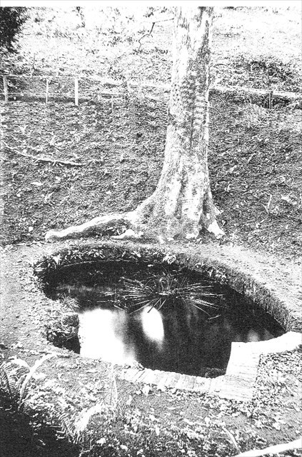
Kirstenbosch Spring Before Botanical Garden Development
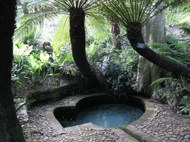
Kirstenbosch spring today discharges into an open collection structure know as Colonel Bird's Bath. This was built in approximately 1811 by Colonel Christopher Bird, at the time Deputy Colonial Secretary. He built this bird-shaped pool (a play on his name) to collect the spring water before being piped to his nearby house. Over time the bath itself became neglected, filled with soil and decaying vegetation despite the water being used by the farm. Between 1902 and 1913 Kirstenbosch was completely neglected. In 1913 as the Botanical Garden was being developed the bath was cleaned out, undergrowth removed, and the bed of the stream below the spring was paved.
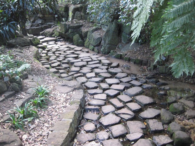
The Paved Bed of the Bath Stream through 'The Dell'
Tree ferns and indigenous trees were planted to create "The Dell". Since the 1920s the natural open spring and attractively landscaped surroundings have made the site of the spring one of the premier attractions of the Kirstenbosch Gardens. Recent emphasis on the educational value of the botanical garden has led to much informative signage: including a display board which provides geological context to the spring.
The Hydrogeology of the Kirstenbosch Spring
Geological Setting and Spring Location
The Kirstenbosch spring is the most natural of the Southern Suburb springs, groundwater feeds directly into an open collection structure from where it flows down the bath stream through the Botanical Gardens feeding a number of pools and supplying irrigation water for the garden. The flow from this spring averages just over 100 m3 per day and has a measured pH of 6.2 making it closer to neutral than the more acidic Newlands, Kommetjie and Albion springs whose pH is closer to 5.5.
As Roger Diamond and others have shown the aquifer delivering water to the springs of Cape Town's southern suburbs is the scree and weathered material overlying the peninsula's basement rocks. The downward movement of water through the scree reaches the peninsula's basement granite in the Botanical Gardens, as can be seen from the geology map. Here the spring emerges from the granite into the head of the bath stream Quaternary sediments. This distinguishes the Kirstenbosch spring from the other southern suburbs springs which emerge from the Malmesbury Group rocks and not from the granite.
From the geology map it is also apparent that the Kirstenbosch spring is close to the south-west to north-east trending zone of post-Cape faulting that Frommurze identified, it does not appear to be related to the fault present in Skeleton Gorge. The geology map also shows a dolerite dyke aligned north-west of the spring, this may further contribute to the spring's location.
Sources
H F Frommurze, 1933; Underground Water Resources. In, S F Haughton The Geology of Cape Town and Surrounding Country, Geological Survey monongraph.
R Diamond, 2014; Stable Isotope Hydrology of the Table Mountain Group. PhD Thesis, University of Cape Town.
C Wu, 2008; Groundwater Occurence in the Table Mountain Area of Cape Town. MSc Thesis, University of the western Cape.
D P McCracken and E M McCracken, 1988; The Way to Kirstenbosch, national Botanical Gardens.
Geohydrological Spatial Solutuons International, 2015; Hydrogeological Investigation of Existing Water Springs in the City of cape Town and Environs.
1:50 000 Geological Series Maps 3318 CD and 3418 AB (1984)
| This EarthCache developed by an |
 |
 |