Upozornenie na aktualizáciu!
Dňa 17.8.2020 boli zmenené indície G a H.
Pokiaľ máte stará čísla, napíšte mi.
Update notification!
Indices G and H have been updated 17.8.2020.
If you have old values, write me.
 Slovenčina
Nízke Tatry sú po Vysokých Tatrách druhým najvyšším hrebeňom Západných Karpát, štyri vrcholy prevyšujú 2000 m (Ďumbier, Štiavnica, Chopok, Dereše). Celé hory vrátane priľahlých oblastí (napr. Starohorské vrchy) sú chránené v rámci Národného parku Nízke Tatry (NAPANT), ktorého správa sídli v Banskej Bystrici. Cez hrebeň vedie červená značka, súčasť diaľkovej "Cesty hrdinov SNP" a súčasne európskej diaľkovej trasy E8.
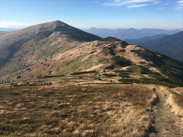
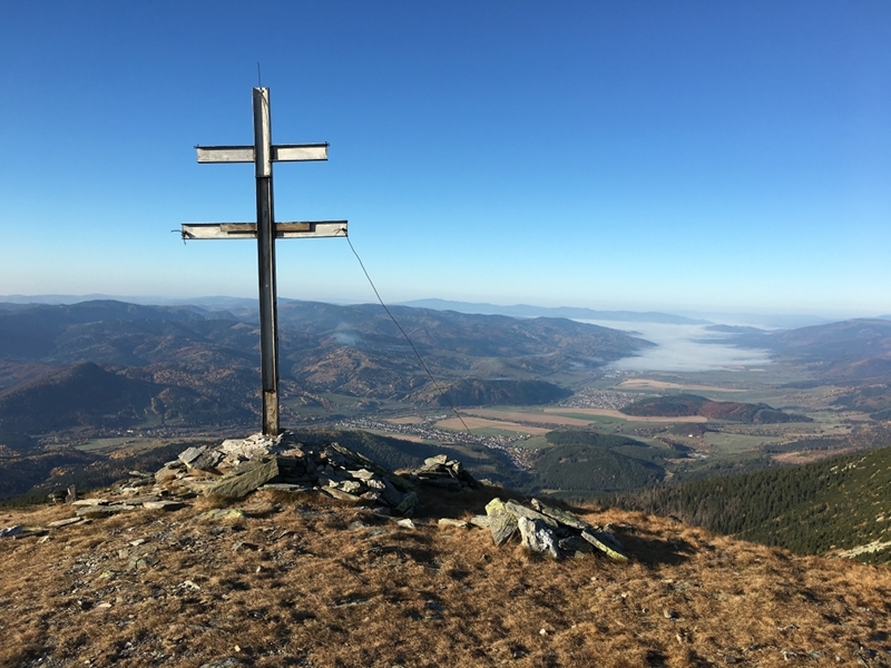
Touto multikeškou vás pozývam na zdolanie práve tejto hrebeňovej trasy. Začína na Donovaloch, kam sa ľahko dostanete autobusom z Banskej Bystrice či Ružomberku, a po takmer 100 km končí v Telgárte, menšej rázovitej obci, kde sú zastávky autobusov i vlaková stanica. Hrebeňovka sa štandardne pohybuje v nadmorskej výške 1500 až 1800 m, profil trasy si môžete prezrieť na tomto odkaze: Mapy.cz.

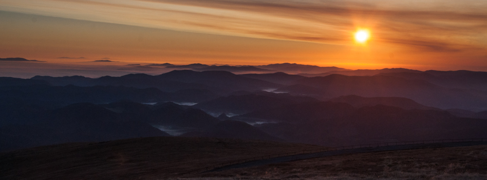
Cesta vám zrejme zaberie 4 až 5 dní, ale vždy si vyhraďte aspoň jeden deň navyše kvôli prípadným problémom (napr. zlému počasiu). Predovšetkým západná časť Nízkych Tatier patrí k najdaždivejším miestam Slovenska, časté sú búrky, hmla a silný vietor. Na druhej strane, za krásneho počasia len ťažko nájdete krajšiu hrebeňovku, s výhľadom na Vysoké Tatry, Slovenské rudohorie, do Horehronského podolia či na Podtatranskú kotlinu.
Symbolom Nízkych Tatier je medveď hnedý, na ktorého môžete naraziť predovšetkým v nižších polohách západnej polovice hrebeňa. Priamo na hrebeňovke sa tu darí kamzíkom (vysadený z Vysokých Tatier v r. 1969) či svišťom, uvidieť možno aj orla; v okolitých údoliach žijú rysy, vlci, diviaky, jelene atď. Väčšina trasy tejto multicache vedie nad úrovňou lesa, miestami pôjdete kosodrevinou, len ojedinele vedie cez les (výstup na Prašivú, medzi Čertovicou a Priehybou, zostup z Kráľovej Hole).
S výnimkou vyhradených miest je zakázané na celom území NAPANT nocovať (vrátane bivakovania). Kompletný zoznam všetkých miest, kde je možné prenocovať (či už na chate alebo pod stanom), ale aj zdroje vody a ďalšie zaujímavosti nájdete v nasledujúcej tabuľke waypointov:


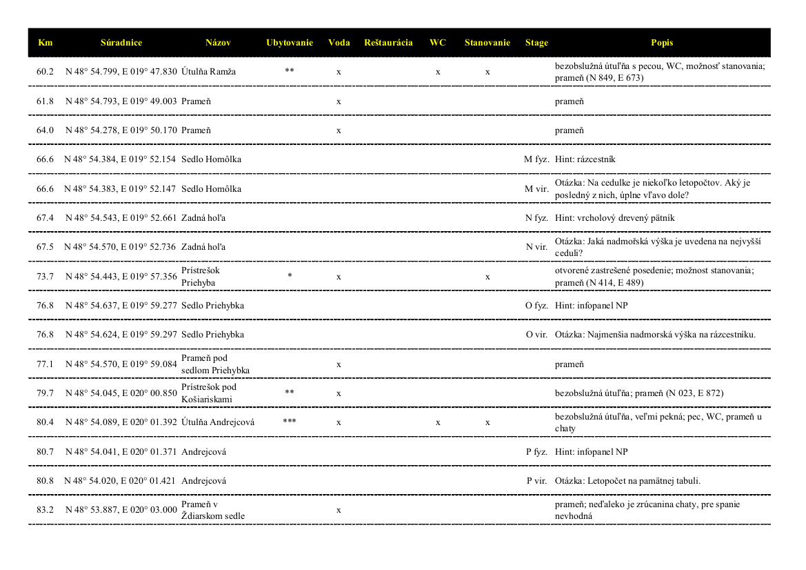
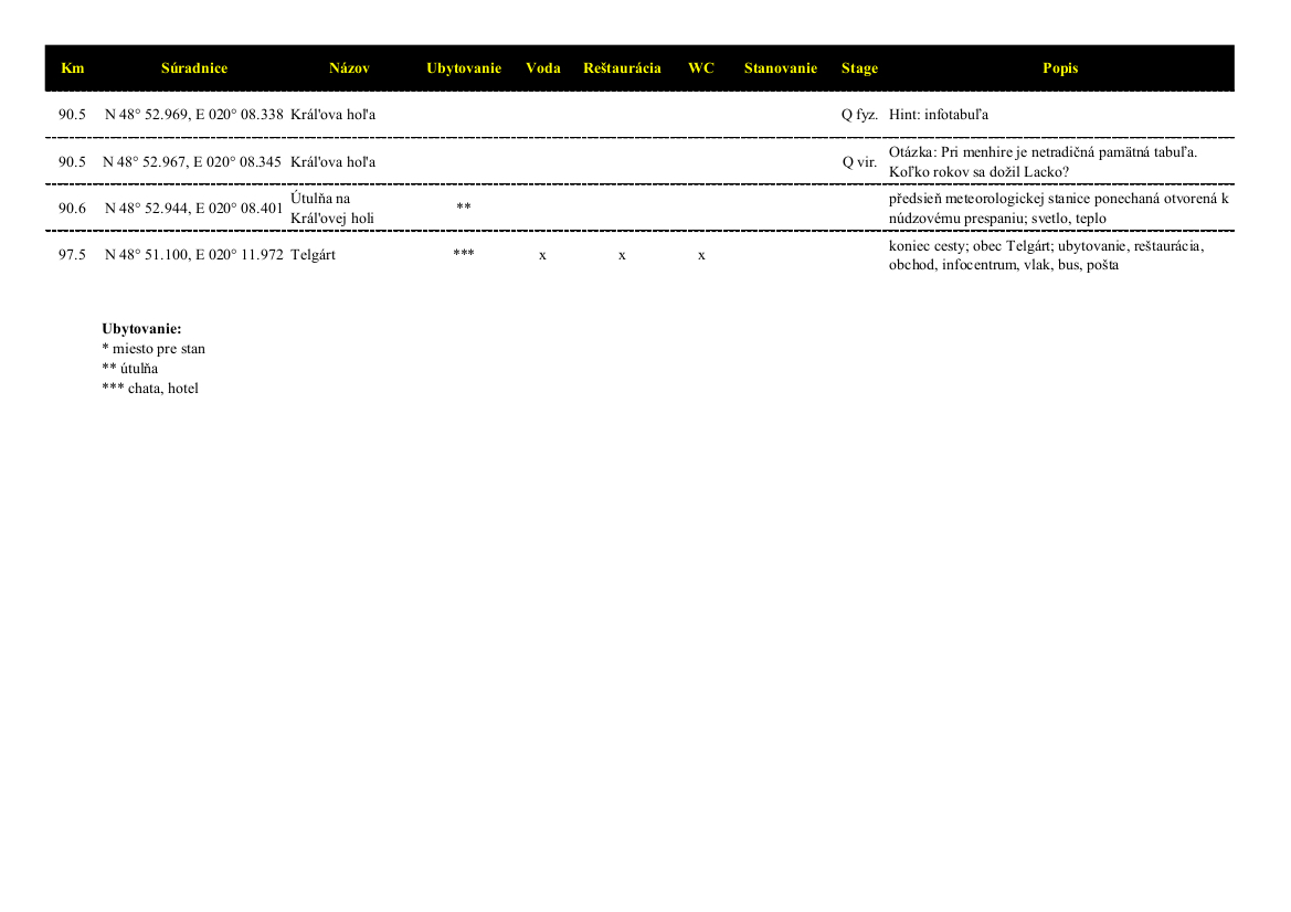
Tabuľku v PDF a XLSX môžete stiahnuť na tejto stránke.
Pre prechod odporúčam mapu SHOCART č. 475 Nízke Tatry (Chopok, Kráľova Hoľa) a sprievodcu S batohom po Slovensku - Nízke Tatry (P. Augustini & D. Kollár ed., 2008), kde sa dozviete nielen viac informácii o vlastnom pohorí, ale hlavne tipy na off-setové výlety (Ďumbier, Jaskyňa mŕtvych netopierov, atď.).
Cache
K úspešnému odlovu tejto multicache stačí pozbierať 17 indícií (A až Q) a doplniť ich do nasledujúcich vzorčekov:
Z = A + B + C + D + E + F + G + H + I + J + K + L + M + N + O + P + Q
XX.XXX = Z * (E - F) - A - J - M
YY.YYY = Z + J * (E - F) - 3
N 48 ° XX.XXX, E 20 ° YY.YYY
Každá indícia je pre istotu v teréne duplicitne, vo fyzickej podobe (hliníkový pliešok s číslom na drevenom objekte), tak v podobe virtuálnej. Obe sú rovnaké, pre prípad, že by došlo napr. k výmene rázcestníkov a číslo sa zmenilo, berte za správnu hodnotu z fyzickej stage.
Ak máte nejakú otázku, neváhajte sa na mňa obrátiť. V teréne môžete využiť moje telefónne číslo (do ČR): +420 723 599 073.
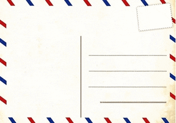
Pohľadnice
V krabici sme okrem niekoľkých darčekov pre vás nechali tiež obálku s pohľadnicami. Ak sa vám keš páčila a chcete nám urobiť radosť, môžete vybrať jednu z pohľadníc a poslať nám ju na predpísanú adresu. Pohľadnice nie sú oznámkované z dôvodu častých obmien poštových známok. Je teda len na vás, či ste ochotní zaplatiť za známku na pohľadnicu do Českej republiky.
Pokiaľ v keši už žiadne pohľadnice nie sú, môžete nám poslať akúkoľvek inú, napríklad z vášho kraja. Radosť nám urobia tiež. Našu adresu nájdete v logbooku a pošta je v Telgárte. ;-)
Záverom
Som presvedčená, že až dôjdete na koniec cesty, usúdite, že finálna krabica nie je tou najdôležitejšou odmenou, ktorú ste za svoju odvahu a vytrvalosť získali. Tou skutočnou nech je vám nezabudnuteľný zážitok z prechodu pohoria, mnoho obrazov nepoškvrnenej prírody a radosť z krásy sveta. A tiež pocit víťazstva a hrdosti, že ste to dokázali.
Prajem vám veľa krásnych zážitkov, slnko v tvári a vietor v chrbte!
Do slovenčiny preložil Šaman. Ďakujem!
 English
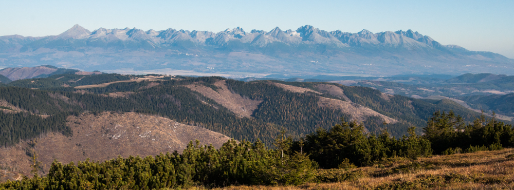
After High Tatras, the Low Tatra Mountains are the second-highest ridge of the Western Carpathians with four peaks exceeding 2000m (Ďumbier, Štiavnica, Chopok, Dereše). Both the mountains and their surroundings (incl. Starohorske vrchy) belong to the Low Tatras National Park (NAPANT) with headquarters in Banska Bystrica. The red-marked ridge path is part of long-distance trails Cesta hrdinov SNP (Trail of the SNP heroes) and E8.
This multi-cache shows you the whole ridge path. It starts in Donovaly with easy access by bus from Banska Bystrica or Ruzomberok and goes for 100km (over 60 miles) to Telgart with both bus and railway station (connections from Telgart are rare, get informed prior to depart!). The path generally stays between 1500 and 1800 metres above sea level, its altitude profile can be displayed at Mapy.cz ("View route elevation profile" in the side-bar).
It takes you 4 or 5 days to finish this voyage, but always reserve at least one more day due to e.g. bad weather. Especially the western part of the Low Tatras belongs to the rainiest regions of Slovakia; storms, fog and strong wind are common throughout the whole ridge. On the other hand, you can hardly find a more beautiful ridgeway in Europe in good weather, with beautiful views upon the High Tatras, the Slovak Ore Mountains, into the Hron River Valley or the Sub-Tatra Basin (see image gallery in this listing).
The brown bear (Ursus arctos) is the symbol of NAPANT, you can chance on it especially in lower western areas of the Low Tatras. The ridge itself is ideal for watching chamois (carried in 1969 from the High Tatras), marmots and you can spot even some eagles; the adjacent valleys are home to lynx, wolves, boars, deer, etc. Most of the trail goes above the tree line through either alpine grasslands or dwarf mountain-pine, sporadically through forest (ascent to Prasiva, between Certovica and Priehyba, descent from Kralova Hola).
It is strictly forbidden to sleep (tent as well as bivouac) anywhere in the National Park except for reserved spots. You can find the comprehensive list of these spots along with other useful points of interest (e.g. water sources) in the following tables:


You can download the table in PDF or XLSX on this webpage.
I recommend you to have map SHOCART no. 475 Nizke Tatry (Chopok, Kralova Hola). Unfortunately, I am not aware of any guide through the Low Tatra Mountains in English, please let me know if you know about one. :) You can find some information e.g. on following link: nizketatry.sk/en.
Cache
The multi-cache is actually easy: you just need to collect 17 numbers (A to Q) and fill into following formulas to obtain final coordinates:
Z = A + B + C + D + E + F + G + H + I + J + K + L + M + N + O + P + Q
XX.XXX = Z * (E - F) - A - J - M
YY.YYY = Z + J * (E - F) - 3
N 48 ° XX.XXX, E 20 ° YY.YYY
Each stage is both physical (a small alluminium label with an imprinted number) and virtual (a question to answer) in order to ensure you will find at least one correct number. Both of them are the same numbers, if not, always trust the alluminium label (and let me know).
If you have any questions, do not hesitate and feel free to contact me either per Profile, or on my Czech mobile phone (+420) 723 599 073 (prefer SMS).
Postcards
The box includes some trinkets for exchange as well as several postcards. If you liked the cache and wanted to cheer us, please chose one of the postcards and send it to the pre-written address. You only would need to pay for a post stamp into the Czech Republic.
Are there no more postcards left, you can send us any other, for example from your home region (our address can be found in the logbook). They will please us very much as well. :)
Conclusion
I am sure that after the journey closes to its end, you will find out that the final cache box is not the most important reward you will gain for your courage and endurance. The real reward is an unforgettable experience from crossing a mountain range, many pictures of unspoiled nature and joy of world's beauty. And the feeling of victory and pride of what you will have done.
I wish you marvellous experience, sun in the face and wind in the back!

This cache became a Geocache of the Week
Groundspeak also included this cache among Our favorite Geocaches of the Week