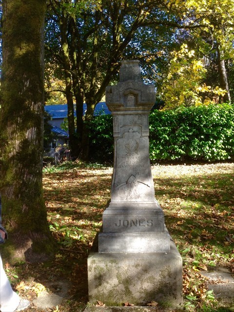
Zion's Founder
In 1850, Nathan B. Jones, a pioneer of 1847, settled at the head of Tanner Creek and platted lots for a community he called "Zion Town". It is unknown if he named the place for Mount Zion, a summit located about a mile to the southeast. Because the name "Zion" for a local post office would have caused confusion, as there had already been two post offices so-named in Oregon, a resident suggested the name "Sylvan", from the Roman deity of the woods Silvanus. The office was established in 1890 and it closed in 1906. Nathan B. Jones, who was considered an eccentric hermit, had wanted Zion Town to become the new capitol of Oregon. He was murdered during the course of a robbery in 1894 and rests beside his father William. A monument was erected between the graves of the two men.
Jones Cemetery is owned and maintained as a public cemetery by the Portland Metro Regional Parks and Greenspaces. Geocaching is allowed. The posted hours are from sunrise to sunset. No pets are allowed. The cemetery can be accessed only through the parking lot of the Westside Vinyard Church. Metro maintains an access agreement with them. There is a gate into the cemetery. It may be closed, but it is unlocked, and visitors are allowed to open it and drive in. The gate is not there to prevent visitors to the cemetery, but to prevent overflow parking from the church. Do not park in the church parking. There are tow away signs. Please close the gate when you leave if it was shut when you arrived.
This is an easy multi. To find the cache, go to the posted coordinates and locate the monument dedicated to Nathan and William. Find the days that they died, add them together and then add 24 to that number to get the final west coordinate. The checksum = 7. The cache is located at: N 45 30.420 W 122 44.0XX
The cache has a waterproof logbook, swag, and a pathtag for ftf. Thanks for looking, enjoy visiting the cemetery and happy caching.