Please note that in order to reach this geocache you must travel by ferry or private boat.
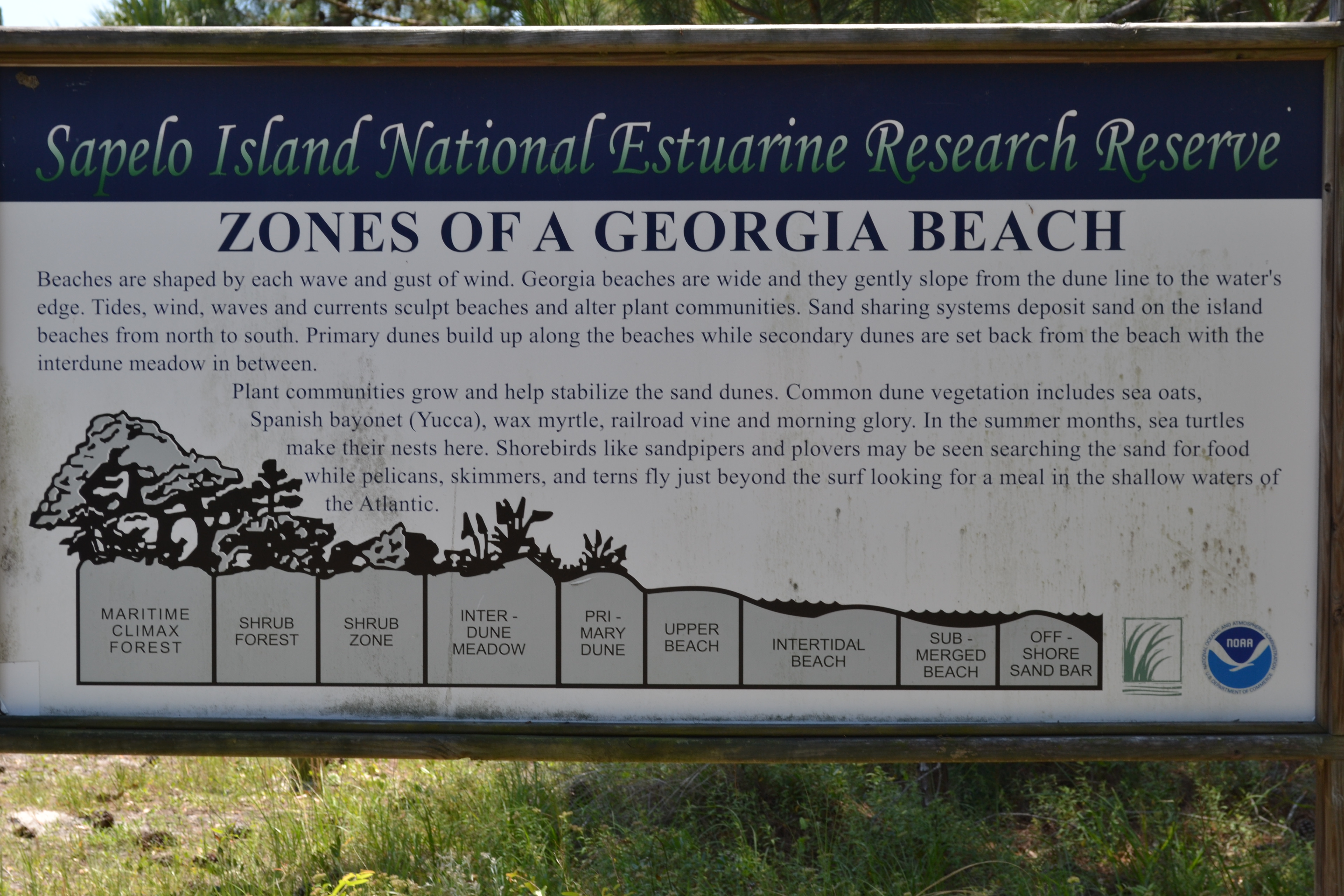
The state of Georgia is known for its beautiful coastline, which is characterized by a gentle sloped shore and extreme tidal ranges. Georgia’s beaches are described as having vast intertidal zones with narrow or nonexistent berms. The intertidal zone is the area that is above water at low tide and under water at high tide, whereas the berm is the area of land that makes up the active shoreline. Georgia’s beaches are also made up of sand dunes, hills that have been built with dry beach sand blown inland and trapped by vegetation. As the sand accumulates, the dunes become higher and wider.
The intertidal zone is the area that is above water at low tide and under water at high tide.The size of the zone is dependent on the tidal range and the slope of the beach. The intertidal beaches of Georgia can extend as much as a quarter of a mile out to sea.
The intertidal zone has little diversity of marine sea life. The waves and daily flooding of seawater make the area a difficult place to reside. The majority of sea life are either found in burrows or scattered about in the wet sand. During low tide, the burrows of some creatures are exposed, such as the ghost shrimp. Filter feeders such as coquina clams position themselves just beneath the surface of the sand after the backwash of the surf passes over them. Terrestrial animals may visit for meals, and aquatic animals may float in with the tide to feed or escape predators.
The area of land that makes up the active shoreline is known as the berm. It is the dry sandy section between the intertidal zone and the dune systems. Although the berm usually stays above water, the area is still influenced by waves. During storms or high tidal ranges, the berm is often flooded. During low tide, the wind pushes sand and rebuilds the zone. The berm does not permit the growth of vegetation.
Dunes are an important part of the beach ecosystem. They act as buffers against wave damage during storms and protect the plant communities from salt water, sea spray and strong winds. The dunes also replenish and maintain the beach at times of erosion.
Salt spray, rapid water drainage, shifting sand, and constant sun exposure make the primary dunes a harsh habitat. Many of the plants that inhabit the dune system have developed adaptations similar to desert plants. Some plants have a deep, single taproot that reaches the water table, while others have far-reaching and widespread fibrous root systems that catch rainfall.
Over time, sea oats have become an established species along Georgia’s coast. Their long leaves and tall heads trap windblown sand that helps the dunes grow. The sand could bury sea oat plants and other plant life as they grow, but the sea oat plants work to rapidly grow new leaves and roots before the sand can build up over them.
The other plants in this type of community suffocate, degrade and ultimately provide organic matter known as humus. The humus helps the sea oat plants to grow and become taller. The State of Georgia prohibits the picking of sea oats because of the vital role these plants play in building and stabilizing dunes.

In order to log this cache as a find, please message or email me with the answers to the following questions!
1) From the posted coordinates, how many zones are you able to easily identify, is it high tide or low tide?
2) If Visiting During Low Tide: How does the soil from the upper beach change as you move down into the intertidal beach? If Visiting During High Tide: How has the tide worked to shape the area right outside of the walk way?
3) What is the dry, sandy section between the intertidal zone and the dune system known as?
4) (Not required, but appreciated!) Please include a picture or two of your group and your discoveries today!
Thanks for taking the time to check out my earthcache! I hope you enjoyed yourself on this beach as much as I have.
Much of information for this earthcache was found at http://gacoast.uga.edu/about/georgia-coast/beach-ecology/ Other information came from the park manager at Reynolds Mansion on Sapelo Island James Bowd.