The description and tasks will teach an earth science lesson of this unique spring coming out of Cave Spring's natural limestone cave
Due to some geocachers use GPS devices with a limited amount of text. This cache page is long, So we place the logging tasks near the top and bottom.
Logging Task
Obviously, please E-mail the answers so you don't give them away.
1.Cave Springs is What type of spring?
2. What is the magnitude classification of Cave Springs? (amount per day will help you figure this out. A bit of math will be needed.
3. Inside the cave you will Step back in time when Cave Spring's natural limestone cave was being created, with its impressive stalagmites and legendary “Devil's Stool” formation. Above the Devil's Stool the are some beautiful white stalagmites. What do they remind you of ?
4. (Not required but recommended) Enjoy the park. Take some pictures and relax. And please take a picture, to post with your log, of your self, group or something, near where spring exits the earth. And Remember, The whole point of this game is to have fun and explore.
First we start with hydrogeology
Hydrogeology that deals with the movement and distribution of groundwater within the rocks of the Earth’s crust such as in aquifers. A spring is any natural situation where water flows from an aquifer to the Earth's surface. It is a component of the hydrosphere.
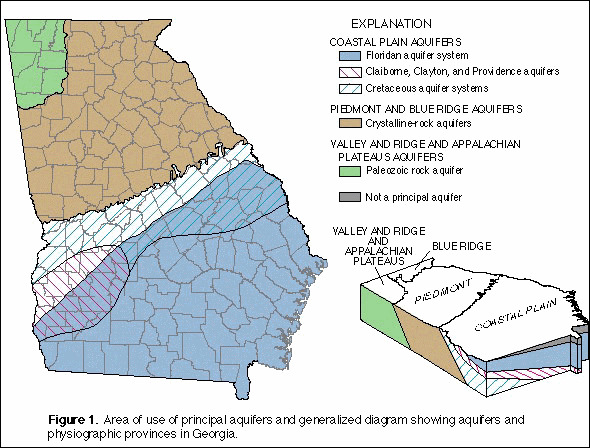 Aquifers in Georgia
An aquifer is an underground layer of water-bearing permeable rock or unconsolidated materials such
as gravel, clay, silt or sand, from which groundwater is contained and transmitted.
Groundwater makes up about twenty percent of the Earth’s fresh water supply. Groundwater is water
located beneath the ground surface in voids or fractures of underground layers of rock. A unit of rock
or an unconsolidated deposit is called an aquifer when it can yield a usable quantity of water The
depth at which fractures and voids in rock become completely saturated with water is called the water
table. Groundwater is naturally replenished by surface water from streams, rivers and precipitation
and eventually flows to the surface naturally when it reaches the water table.
This natural discharge often results in springs.
Springs
Indians and early settlers were known to depend on the crystal clear waters of Cave Springs. Many local folks stop by and fill containers with the water of the spring. Springs are a small part of the water cycle. Basically the water of our Earth constantly evolves and is moving through a series of changes. Cave Springs is part of that cycle.
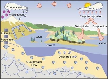
The Cycle of Water
The largest springs like Cave Springs are formed in limestone and dolomite in the karst topography of the region.
Definition of Karst: – A landscape characterized by the presence of caves, springs, sinkholes and losing streams, created as groundwater dissolves soluble rock such as limestone or dolomite.
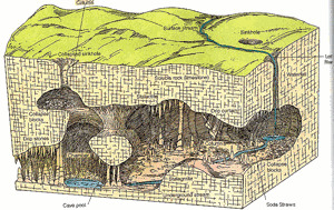 Karst Cross Section
Limestone fracture relatively easily. When weak carbonic acid (formed by rainwater and carbon dioxide) enters these fractures it dissolves bedrock. . (Please note the limestone formation above Cave Springs with several fractures). When it reaches a horizontal crack, crevice or a layer of non-dissolving rock such as sandstone or shale, it begins to cut sideways As the process continues, the water hollows out more rock, eventually creating airspaces, the largest of which are known as caves or caverns. This process usually takes thousands of years to complete. When the spring surfaces, gravity takes over and as with all streams, the flow is downhill.<</font>
Spring location
Spring location is related to geologic structure and topography. In the Valley and Ridge Province many springs are located on or near anticlinal (Anticlinal definition: inclining in opposite directions from a central axisaxes) and around the noses of plunging anticlines. Open tension fractures tend to be concentrated in these places, and in the case of plunging anticlines, water-yielding beds may drain in the direction of plunge. The bases of sandstone ridges are, in general, the sites of major springs. Cave Springs like other larger springs tend to be in valleys, and some form the headwaters of streams.
.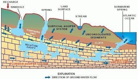
An Example of Water Flow with a Spring Formation
Water Flow Amount
The amount of water that flows from springs depends on many factors, including the size of the caverns within the rocks, the water pressure in the aquifer, the size of the spring basin, and the amount of rainfall..
Springs are classified by the volume of the water they discharge.
The largest springs are called
"first-magnitude," defined as springs that discharge water at a rate of at least 100 cubic feet
of water per second, down to eighth magnitude where less than one pint per minute flows.
Zero magnitude is reserved for past sites with no current flow.
1st Magnitude - > 100 cubic feet per second
2nd Magnitude - 10 -100 cubic feet per second
3rd Magnitude - 1 - 10 cubic feet per second
4th Magnitude - 100 gallons per minute – 1 cubic feet per second
5th Magnitude - 10 to 100 gallons per minute
6th Magnitude - 1 to 10 gallons per minute
7th Magnitude - 1 pint per minute to gallons per minute
8th Magnitude - Less than 1 pint per minute
0 Magnitude - no flow (sites of past/historic flow)
Types of Springs
Springs are named for how they flow, and there are four main types . The first type of spring is a
gravity spring. This is just what it sounds like - these form from the pull of gravity. The water gets pulled down through the ground until it reaches a layer it can't penetrate. Because it has nowhere else to go, it starts flowing horizontally until it reaches an opening
and water comes out as a spring. These are usually found along hillsides and cliffs. Next, we have
artesian springs, which come from pressure in confined aquifers forcing the water to the surface. The pressure inside the confined aquifer (from being smooshed between those impermeable layers)
is less than the pressure outside the aquifer, so the water moves in that direction Any cracks or holes in the land will easily let the water escape.
seepage spring, which as you may have guessed, is groundwater seeping out at the surface. Seepage springs slowly let water out through loose soil or rock and are often
found in land depressions or low in valleys.
Finally, we have a tubular spring. These springs occur in underground cave systems, which resemble underground highways. These tubes, or channels, are made of limestone, and as water moves through this type of rock, it dissolves some of it away. Tubular springs are some of the largest springs on Earth, and the tubes themselves can be so small that you can't see them or large enough to walk through!
History Note:
People for millennia have use the spring with it's fresh, tasty water pouring out of the limestone mountain. The Creek Indians called it home for a long time before the Cherokee Tribe drove them out. Then, the settlers drifted into the area and drove the Cherokee away
Cave Spring, Ga.
This Earthcache is the entrance to a cave located
in Rolater Park, 13 Cedartown St., Cave Spring, Georgia 30124
Cave Spring, its European settlement begun in the mid 1820's in one of the loveliest parts of the Cherokee Nation,and is a small town in beautiful Vann's Valley, located about 14 miles southwest of Rome< and 5 miles east of the Alabama state line on US HWY411S / GA HWY53.
The town of Cave Spring was named after the cave, and get all its water from the cave.
Cave Spring, Ga. is said to be one of those places that is quintessential Georgia. In the years past it was where everyone knows your business and people looked out for other people's kids..
Cave Spring's original claim to fame is its namesake mineral spring,
flowing from the cave in Rolater Park, its 29 acre site having been given to the
citizens of Cave Spring by Dr. Joseph B. Rolater.
Water, Water,
Visible in the Cave is the town's namesake spring that produces 2 million gallons a day
of the purest, best-tasting water you're likely to find anywhere.
People from miles around come to fill jugs and take home the award-winning water.
About Rolater park
NOW A little about Rolater park, where the Cave Spring is located. The cave's spring overflows into a serene reflection pond and small stream, The water enters a one and a half acre swimming pool. The pool is the second largest pool in Georgia, and is the shape of the state out line. the water is a constant, 57-degree coolness year round.
Years ago when I was growing, the park was the former home of GSD (GA School For The Deaf) It was once known for the Spring fed swimming pool, park and GSD that sat just behind the pool. GSD was home to many deaf children over the years.
Finding "Cave Springs Hydrogeology" Earthcache
has a self glided tour and we feel you will enjoy the tour so we have posted the hours and fees for you to consider.
If you take the Cave Tour, you will a full perspective of how the spring leaves the under ground world. And you will Step back in time when Cave Spring’s natural limestone cave was being created, with its impressive stalagmites and legendary “Devil’s Stool” formation. You might see were the water come into the cave.
You’ll welcome its constant, 57-degree coolness on a hot summer’s day.
The Cave, located in Rolater Park, It is open daily from May to September; 11am-5pm Monday through Friday, and 10am-5pm on Saturday and Sunday, and by appointment at other times.
Fee: $1.00 per person. self glided tour.
We are sure You will enjoy the Earth Cache, the Spring, the cave, and all that is around it.
Logging Tasks
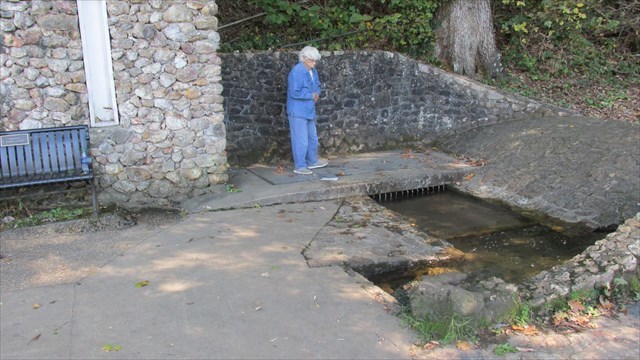
C/Os wife watching the coming out of the mountain.
This is the type picture we would love to see with the logs.
There is a lot of good information about springs, We hope you read and enjoyed it all, but to log it, you can get a picture of your self, group or something, near Where spring exits the earth, and post with your log, but that is optional. Then, email me the answers to these questions.
Obviously, please E-mail the answers , so you don't give them away.
And try to E-mail and Log the same day. Thanks!
1.Cave Springs is What type of spring?
2. What is the magnitude classification of Cave Springs? (amount per day will help you figure this out. A bit of math will be needed.
3. Inside the cave you will Step back in time when Cave Spring's natural limestone cave was being created, with its impressive stalagmites and legendary “Devil's Stool” formation. Above the Devil's Stool the are some beautiful white stalagmites. What do they remind you of ?
4. (Not required but recommended) Enjoy the park. Take some pictures and relax. And please take a picture, to post with your log, of your self, group or something, near where spring exits the earth. And Remember, The whole point of this game is to have fun and explore.
I will email you if you if you have the wrong answer. Thank you for finding my Earthcache.
------- Works Cited -------
https://pubs.usgs.gov/ha/ha730/ch_l/L-text5.html
http://study.com/academy/lesson/springs-definition-formation-types.html
https://en.wikipedia.org/wiki/Spring_(hydrology)
http://study.com/academy/lesson/springs-definition-formation-types.html
https://water.usgs.gov/edu/watercyclesprings.html
http://www.cityofcavespring.com/rolater.asp
http://www.rolaterpark.com/
http://romegeorgia.org/attraction/cave-spring-cave
