Neste local das praias do Paraná fica uma das regiões sensíveis à fortes erosões, eventualmente agravadas pelos eventos conhecidos como "ressacas".
Ressaca é o movimento anormal das ondas do mar sobre si mesmas na área de rebentação, causada por rápidas e violentas mudanças climáticas, o mar agitado inunda a faixa de areia e as ondas quebram bem próximas da orla, costuma alagar avenidas e danificar construções à beira-mar
In this place of the beaches of the Paraná is one of the regions sensitive to the strong erosions, possibly aggravated by the events known like "Ressacas" (undertow).
Dangerous undertow is the anormal movement of the sea waves in the coast line, caused by rapid and violent climatic changes, the rough sea floods the sand strip and the waves break close to the shore, often flooding avenues and damaging buildings on the edge - sea
Os problemas costeiros são decorrentes principalmente de uma ocupação inadequada, muito próxima da linha de costa.
Além da destruição das dunas frontais que funcionam como estoque de areia para a praia, não foi deixado espaço suficiente para que se processem os ciclos naturais de progradação / retrogradação.
Em alguns casos a ocupação se deu invadindo a própria praia, e alterando o equilíbrio do sistema praial.
Na maioria dos casos onde se verificaram problemas erosivos, estes foram causados por interferência antrópica (relativo à ação do homem), notadamente praia Brava de Caiobá, Praia Central de Matinhos, Balneários Flamingo e Riviera e entre o Canal do DNOS e Ponta do Poço.
Os valores e distribuição da progradação e retrogradação verificados na costa paranaense nas últimas cinco décadas, não indicam tendência geral que possa ser atribuída a mudanças globais. Eles podem ser explicados em cada caso pela dinâmica natural local ou pela interferência antrópica com esta dinâmica.
-Progradação é um processo natural de ampliação das praias, provocados pelo mar
-Retrogradação é a transgressão da linha de costa
The coastal problems are mainly due to an inadequate occupation, very close to the coastline.
In addition to the destruction of the sand dunes on the beach front, there was not enough room left for the natural cycles of degradation / retrogradation.
In some cases the occupation occurred invading the beach itself, and altering the balance of the beach system.
In most cases where there were erosive problems, these were caused by anthropic interference (related to the action of man), notably Brava de Caiobá Beach, Matinhos Central Beach, Flamingo and Riviera Spas and between the DNOS Channel and Ponta do Poço.
The values and distribution of the degradation and retrogradation observed in the coast of Paraná in the last five decades do not indicate a general tendency that can be attributed to global changes. They can be explained in each case by local natural dynamics or by anthropic interference with this dynamic.
-Degradation is a natural process of beach expansion, provoked by the sea
-Retrogradation is the transgression of the coastline

Classificação deste trecho da costa de acordo com sua estabilidade (1993)
Classification of this stretch of coast according to its stability
Praia Brava de Caiobá
A Praia Brava de Caiobá, tem direção norte-nordeste, extensão de 3,2 km e está limitada pelos pontais rochosos da Ponta de Matinhos e "Morro do Boi" ou "de Caiobá". As partes central e norte são do tipo oceânico, sem influência direta de desembocadura e a parte sul com influência do lobo frontal do delta de maré vazante da Baía de Guaratuba.
A praia era constituída por areia fina e média, sendo que a classe modal predominante na parte sul era areia fina e na parte norte areia média, sendo os sedimentos bem moderadamente selecionados e assimetria negativa. O diâmetro médio e a inclinação da praia aumentavam de sul para norte, no sentido do transporte, enquanto a seleção diminuía no mesmo sentido. Posteriormente, se identificou que na parte norte da praia a areia era grossa com diâmetro médio entre 0,45 e 0,84 phi. Este aumento do diâmetro médio decorre provavelmente do intenso processo erosivo que vem ocorrendo neste setor da praia desde a década de 1990.
Como foi mencionado, a parte sul da Praia de Caiobá está influenciada pelo delta de maré vazante da Baía de Guaratuba. Em 1954 as barras frontais do delta localizavam-se nas proximidades do Morro de Caiobá, não afetando a configuração da praia. Já, em 1965, as barras haviam sido deslocadas para o norte, configurando uma barra transversal à praia que se projetava até o início da Praia Brava, que provocava refração de ondas e sedimentação neste setor da praia. Em 1980, a barra transversal tinha avançado 300 m para norte, deslocando
o setor de sedimentação . Ao norte do esporão as ondas, principalmente as provenientes do sudeste, atingiam a praia frontalmente, gerando uma zona de divergência que favorecia a erosão.
Brava Beach Caiobá
Praia Brava de Caiobá has a north-northeast direction, extension of 3.2 km and is bounded by the rocky points of Ponta de Matinhos and "Morro do Boi" or "Caiobá". The central and northern parts are of the oceanic type, with no direct influence of mouth and the southern part with influence of the frontal lobe of the ebb tide delta of the Bay of Guaratuba.
The beach was composed of fine and medium sand, and the predominant modal class in the southern part was fine sand and in the northern part of the sand, the sediments were moderately well selected and negative asymmetry. The mean diameter and slope of the beach increased from south to north in the direction of transport, while selection decreased in the same direction. Subsequently, it was identified that in the northern part of the beach the sand was coarse with a mean diameter between 0.45 and 0.84 phi. This increase in average diameter probably results from the intense erosive process that has been occurring in this sector of the beach since the 1990s.
As mentioned, the southern part of Caiobá Beach is influenced by the ebb delta delta of Guaratuba Bay. In 1954 the frontal bars of the delta were located near the Morro de Caiobá, not affecting the configuration of the beach. Already in 1965, the bars had been moved to the north, forming a cross bar to the beach that projected until the beginning of Brava Beach, which caused wave refraction and sedimentation in this sector of the beach. In 1980, the crossbar had advanced 300 m to the north, shifting
the sedimentation sector. To the north of the spur, the waves, mainly from the southeast, reached the beach frontally, generating a zone of divergence that favored erosion.

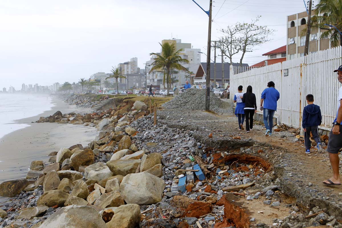
Erosão na parte norte da Praia Brava de Caiobá após a ressaca de maio de 2001.
Erosion in the northern part of Praia Brava de Caiobá after the May 2001 undertow.
O processo erosivo que existia na parte central da praia Brava de Caiobá, no início da década de 1980, era decorrente da construção inadequada da avenida Beira Mar, que tinha ocupado parte da praia e alterado a sua curvatura natural. As obras de contenção posteriores, demandaram a construção de esporões transversais na praia para conter areia. Como na área, a deriva litorânea predominante é de Sul para Norte, a captação de areia pelos esporões provocou escassez de sedimento e consequentemente erosão nas praias localizadas ao norte das obras de contenção.
Isto, demandou novas obras, que por sua vez provocaram erosão mais ao norte. Assim, até o fim da praia, num claro exemplo de retroalimentação positiva. Novas obras foram executadas em diversas oportunidades porém, no setor norte o problema erosivo ainda não foi resolvido.
Atualmente existem projetos de controle de erosão envolvendo a construção de esporões, quebra-mares e alimentação artificial.
-Esporões, também conhecidos por headland ou quebra-mar, servem para dissipar a energia das ondas e segurar a areia na costa.
The erosive process that existed in the central part of Brava de Caiobá beach in the early 1980s was due to the inadequate construction of edge sea Avenue, which had occupied part of the beach and altered its natural curvature. Subsequent containment works have required the construction of transverse spurs on the beach to contain sand. As in the area, the predominant coastal drift is from South to North, the capture of sand by the spurs caused a shortage of sediment and consequently erosion in the beaches located to the north of the containment works.
This demanded new works, which in turn caused erosion further north. So, to the end of the beach, in a clear example of positive feedback. New works were executed in several opportunities but in the northern sector the erosive problem has not yet been solved.
Currently there are erosion control projects involving the construction of spurs, breakwaters and artificial feeding.
-Spurs, also known as headland or breakwater, serve to dissipate the energy of the waves and hold the sand on the coast.


Esporões instalados na faixa de areia de Caiobá
Spurs installed in the strip of sand of Caiobá
Perguntas: