Hello once more! My name is Geo and I'm the head elf at the North Pole. Last year's Cachemas was such a success, Santa commissioned us to release a new series, set arrive just in time for Cachemas! This time, the elves and I have decided to focus on a more geological approach, and show you nature's beauty, beyond the snow! The Geo's Geology series contains two challenging and educational Earthcaches to teach you about all the North Pole region has to offer. Be sure to read the entire cache page and obtain the required equipment (and a friend) before embarking on your trek. Once completed, you can email your answers to me via Geocaching.com!
.
*Disclaimer* This Earthcache is not suited for small children. The terrain approaching GZ is calm, but the final 10 feet leading to the Marcellus formation is steep and littered with broken rock fragments. Please attempt this cache at your own risk.
What is a Marcellus Formation?
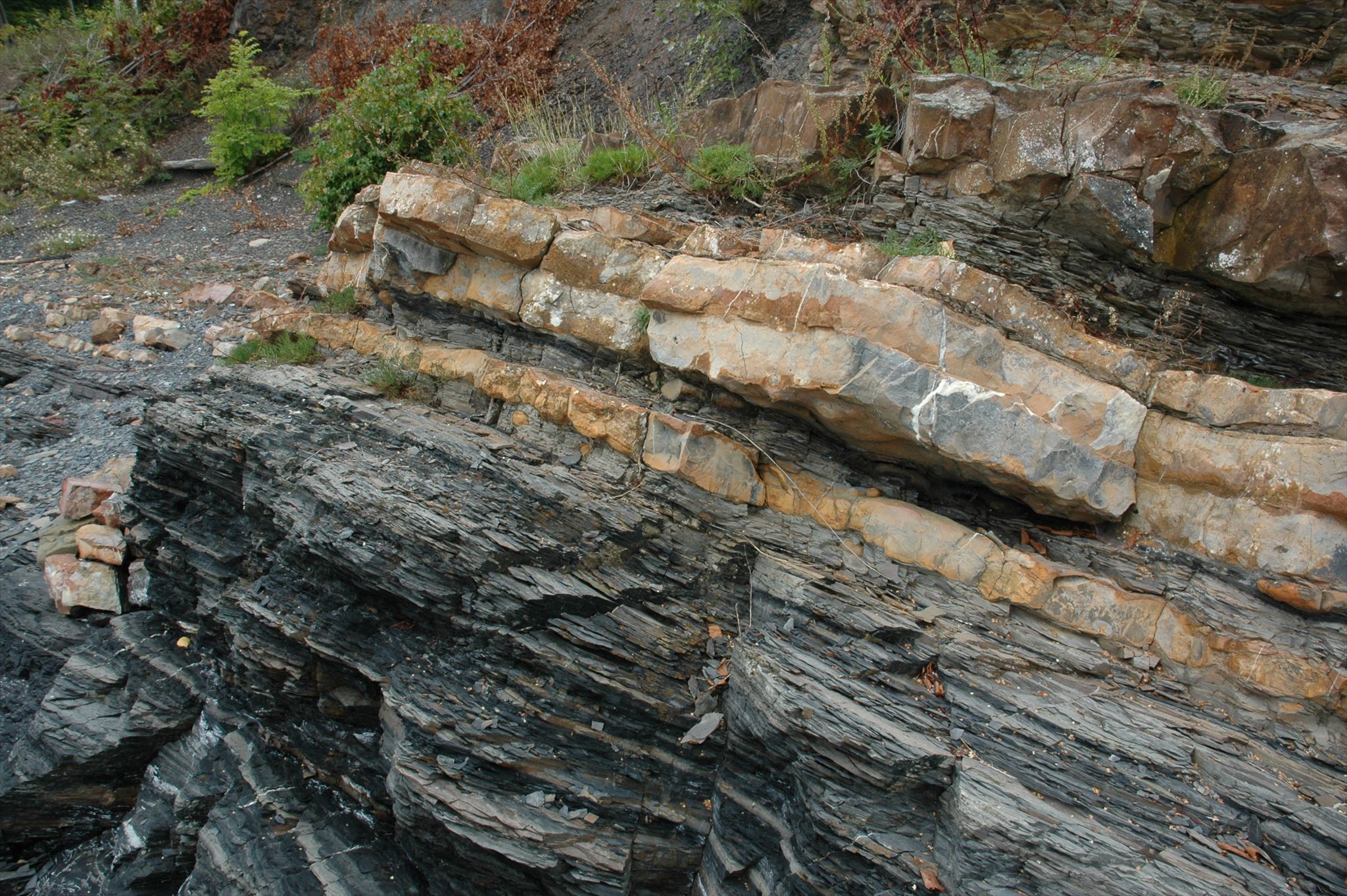
Marcellus formations are small rock formations composed of several limestone bands, primarily of shale. These rock walls are formed when several layers of rock are compressed under intense pressure. Its sedimentary structure, or bedding, is moderately well developed. Like most shales, it tends to split easily along the bedding plane, a property known as fissility. In geology, fissility is the ability or tendency of a rock to split along flat planes of weakness (“parting surfaces”). These planes of weakness are oriented parallel to stratification in sedimentary rocks. In a Marcellus formation, lighter colored shales in the upper portion of the formation tend to split into small thin-edged fragments after exposure.
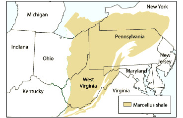
Marcellus formations are found primarily in the North Eastern United States, extending from WV to NY. Named for a distinctive outcrop near the village of Marcellus New York, this formation appears throughout much of the Appalachian Basin. Marcellus formations were formed in the Middle Devonian epoch, as deceased mineral material gets compressed under pressure, which creates the bands present at GZ. The largest Marcellus formation recorded in West Virginia is 60 meters (200 feet) thick!
Marcellus Bands
The Marcellus appears in outcrops along the northern margin of the formation in central New York. There, the two joint planes in the Marcellus are nearly at right angles, each making cracks in the formation that run perpendicular to the bedding plane, which lies almost level. These joints form smooth nearly vertical cliffs, and the intersecting joint planes form projecting corners in the rock faces. Once exposed, the weathered faces lose most of their organic carbon, turning from black or dark gray to a lighter shade of gray.
Outcrops of the Marcellus can contain very small beds that resemble coal. The New York outcrops, and others further south in Pennsylvania and New Jersey, were extensively excavated in the early 19th century, sometimes at great expense, in the false hope of finding minable coal seams. Seaweed and marine plants probably formed the false coal. True coal is formed from terrestrial plants, which only began to appear in Marcellus and later fossils.
.
Facies
In geology, a facies is a body of rock with specified characteristics, which can be any observable attribute of rocks such as their overall appearance, composition, or condition of formation, and the changes that may occur in those attributes over a geographic area. It is the sum total characteristics of a rock including its chemical, physical, and biological features that distinguishes it from adjacent rock.
Talus
Talus is a term that refers to the accumulative rockfall at the base of a rock face or cliff. The degree of sameness in size, layering, and homogeny of the talus is referred to as sorting. Contributing rock that is irregularly fractured does not weather evenly and because it breaks off in large irregular pieces, contributes to a poorly sorted talus slope. The recognition and characterization of talus slopes is often important in determining the potential for mass movements (landslides, etc.). Movements occur whenever the talus slope exceeds the critical angle.
QUESTIONS!
At the coordinates provided you will find a fully exposed Marcellus formation complete with 4 individual bands. These bands are visible from the ground, but in order to complete all the questions you will need to scale the cliff to measure each band, please be careful. Answer each of the questions and email your findings to me via geocaching.com.
*Rules* - Below, are 17 questions relating to the Marcellus formation. To obtain credit for this Earthcache, you must correctly answer 60%, or 10, questions. You must answer the five questions marked with a star (*), but you may choose any other five from the remaining twelve. It is a good idea to answer as many questions as you can, in the event you get one wrong, you will still have a passing grade.
*Please Note* - There is a lot of information to be gathered from this site, and therefore the questions are quite extensive. Please be sure to answer them completely and thoroughly. In some categories, when prompted, you may choose one or two of the questions from the aforementioned category to answer, and discard the rest.
Part A. General Marcellus Information
*A.I.1: Label each of the 4 facies bands (from bottom to top) on the Marcellus face and list their height (in inches) and composition. (Shale or Limestone)
A.I.2: Are the bands evenly spaced? If yes, why do you believe they formed in this way?
A.I.3: What epoch was this Marcellus formed in?
Part B. Rock (and roll) Bands
*B.I.1: Take note of the first layer of the Marcellus formation, what mineral makes up this band? What other mineral is it commonly confused with and why?
*B.I.2: Bands one and three are very similar and share a lot in common including what specific element?
*B.I.3: Using your answer from B.I.2, approximately how much (percent) of this element is present in band one? Band three?
B.I.4: What do these two bands tell us about the overall formation and age of this Marcellus formation?
Part C. Talus
*C.I.1: Is talus present at this Marcellus formation? If so, which band has the most evidence of fissility?
C.I.2: Use textual evidence from the cache page to support your claim in C.I.1.
C.I.3: How do you think the rock fractured?
C.II.1: Locate and identify a piece of fractured talus located at the base of the Marcellus. Find the length and width of the piece.
C.II.2: Compare these dimensions to other talus fragments at GZ, how are they similar? Different?
C.II.3: Describe the two samples. (Color, shape, texture) What do the edges tell us about the exposed weatherization of the formation?
C.III.1: Take note of the larger rocks at the base of the cliff, is this an example of talus? Why or why not?
C.III.2: Were these rock fragments once part of the Marcellus formation?
Part D. Math (*Choose one)
D.I.1: What percentage of the overall formation are composed of shale rock? Limestone?
*Note* - When completing your calculations, take into consideration each band doesn't make up equally 1/4.
D.II.1: Assuming that the Marcellus formation is vertical (as per the cache page), stand 20 feet away from the cliff and find the angle of acceleration to the top of the Marcellus formation.
(Hint: you will need to find the distance from the ground to the top of the Marcellus formation.)
Extra Credit: Take a photo of yourself at GZ. Be sure to avoid revealing too much of the formation.