The purpose of this earthcache is to provide people like me, who know very little about the environment, with an opportunity to increase their knowledge-base and to develop a deeper appreciation and respect for the world we live in. The lessons and related questions are brief, quick to answer and easy to remember for a lifetime! As with all Earthcaches, please be respectful of the land. PLEASE AVOID WALKING ON THE DUNES AND BEACH IN ORDER TO PROTECT THE LAND AND WILDLIFE.
Glossary of terms:
Ecosystem: all the plants and animals that live in a particular area together with the complex relationship that exists between them and their environment.
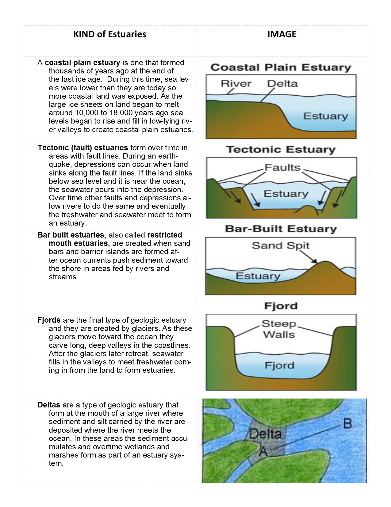
Estuaries: bodies of water in coastal areas that are formed when fresh water from rivers flows into and mixes with salt water from the ocean. In estuaries, the fresh river water is blocked from streaming into the open ocean by either surrounding mainland, peninsulas, barrier islands, or fringing salt marshes. The estuary gathers and holds an abundance of life-giving nutrients from the land and from the ocean, forming an ecosystem that contains more life per square inch than the richest Midwest farmland.
Estuaries are a critical source for much of our ocean life. They provide essential habitat for over 75 percent of our nation's commercial fish catch. Commercial and recreational fishing, boating and tourism also provide more than 28 million jobs. Estuaries, in short, are national treasures -- vital ecological and community resources whose health affects our health and the vibrancy of our communities and economy.
Along with variations in size, estuaries also vary based on their geology (kind) and water circulation (type).
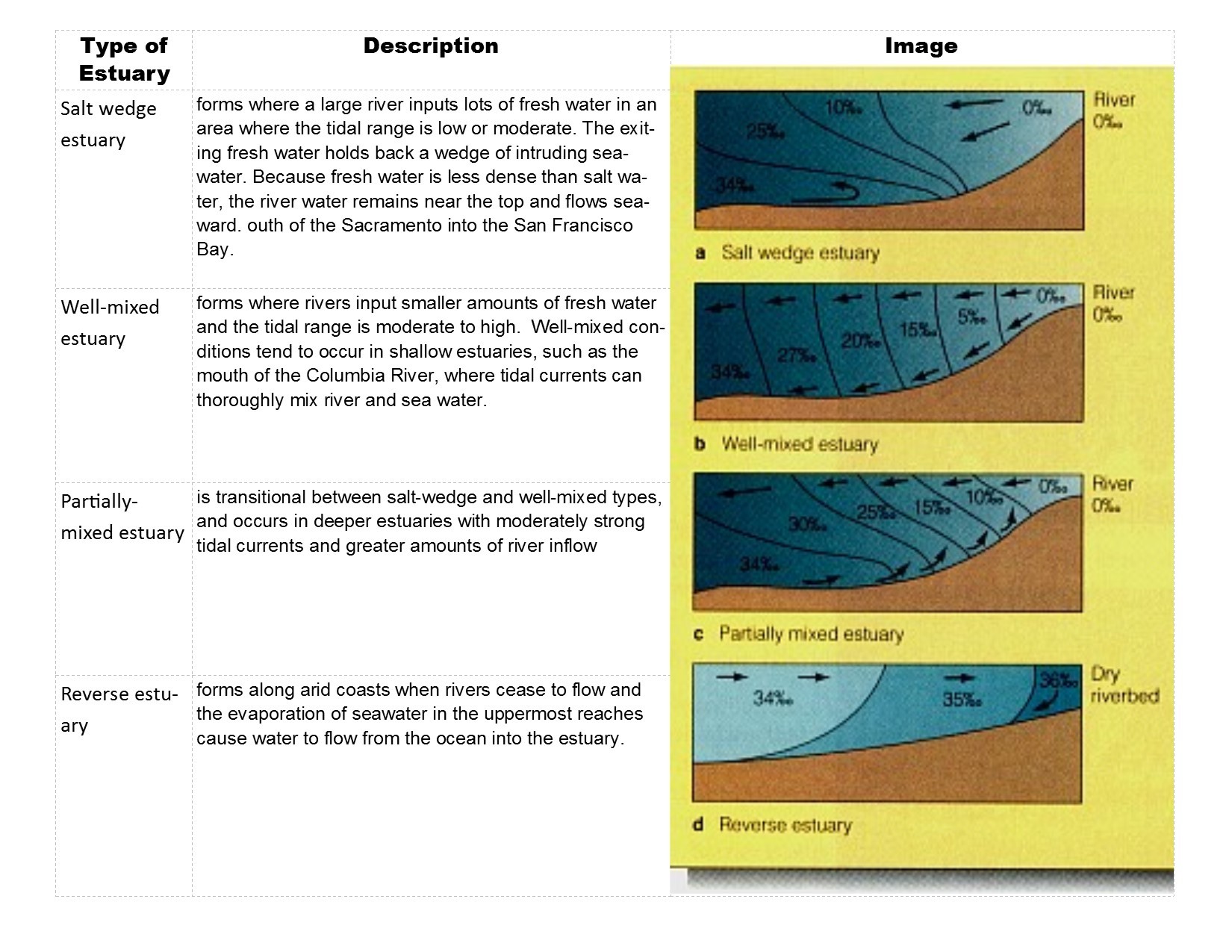
Four Types of Estuaries: Based on their natural characteristics and level of salinity, estuaries can be divided into four main types: salt-wedge, well-mixed, partially-mixed and reverse (or lagoon).
Six Principles of Estuaries:
- Principle 1: Estuaries are interconnected with the world’s oceans and with major systems and cycles on Earth.
- Principle 2: Estuaries are dynamic ecosystems with tremendous variability within and between them in physical, chemical, and biological components.
- Principle 3: Estuaries support an abundance of life and a diversity of habitats
- Principle 4: Ongoing research and monitoring is needed to increase our understanding of estuaries and to improve our ability to protect and sustain them.
- Principle 5: Humans, even those living far from the coast, rely on goods and services supplied by estuaries.
- Principle 6: Human activities can impact estuaries by degrading water quality or altering habitats; therefore, we are responsible for making decisions to protect and maintain the health of estuaries
Kettle pond: A kettle is a shallow, sediment-filled body of water formed by retreating glaciers or draining floodwaters. The kettles are formed as a result of blocks of ice calving from glaciers and becoming submerged in the sediment on the outwash plain. A kettle pond receives its water from precipitation, the groundwater table, or a combination of the two and is vegetated.
According to Robert Williams of the Nantucket Pond Coalition, the island of Nantucket plays host to three types of naturally-formed ponds and lakes: 1) kettle ponds; 2) long, vertical, glacial river ponds and 3) brackish (or tidal) ponds.
Deemed one of the island’s cleaner bodies of water by the Massachusetts Estuaries Project, Sesachacha Pond is Nantucket’s largest kettle pond and is probably the deepest pond on the island at a depth of 43 feet.
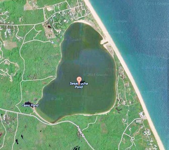
Historically, Sesachacha Pond had been opened to tidal exchange each spring and fall to maintain salinity, manage nutrients and to allow passage of marine larvae and herring. From the 1600’s to the present, it is likely that Sesachacha Pond and the six-other major coastal ponds on Nantucket (Long Pond, Squam, Tom Nevers, Miacomet, Hummock and Capaum) have all been opened to the sea on a more-or-less regular basis. (Interesting side note: years ago, Native Americans built basic piers by using large rocks that they hauled to the pond and laid out into the water at a certain distance and height, so they could walk out into the water and spear fish in the deeper parts of the pond. These rocks can only be seen right after the pond is opened to the ocean.)
From 1874, when fish packed in ice were first shipped from Nantucket to city markets, until 1960 when excessive transportation costs made shipment unprofitable, sale of fish from the ponds was a lucrative seasonal industry. After 1960, eels, alewives and perch were in less demand for food, perhaps due to changing tastes. Nantucket's offshore fin-fishery declined and mainland-based fishing vessels provided their own bait. Until 1933, pond opening was an informal process, accomplished by groups of fishermen working together to dig ditches when pond levels were high enough to provide sufficient "head" for eroding substantial channels. From 1933 until 1981, the Town of Nantucket paid for heavy equipment to open ponds each year. In 1981, pond opening ceased under provisions of the Massachusetts Wetlands Protection Act. The pond was not opened from 1981-1991, resulting in a freshening of Pond waters and a loss of all marine species. As is the case with Hummock Pond, also a kettle pond, Sesachacha Pond is currently maintained as part of an estuarine system by a spring and a fall breaching of the barrier beach, and is a perfect example of a bar built estuary.
A majority of the land surrounding Sesachacha is currently managed by the Massachusetts Audubon Society. The Massachusetts Audubon Society, founded in 1896 by Harriet Hemenway and headquartered in Lincoln, Massachusetts, is a nonprofit organization dedicated to "protecting the nature of Massachusetts." With more than 125000 members and supporters, Mass Audubon protects 36500 acres of land throughout Massachusetts, saving birds and other wildlife, and making nature accessible to all. It is with their permission that this Earthcache is located on their property.
Sesachacha’s current ecosystem is home and habitat for shellfish and sea grasses, and is a breeding ground for a number of commercial offshore marine fisheries. Striped bass, small bluefish, flounder, white perch tomcod, American eels and blueback herring are known to live in the pond. Ospreys from other island locations fish there. Great blue and black-crowned night herons, egrets and smaller shore birds work the shores for food. And the pond is a haven for many sea ducks spending the winter in Nantucket waters including long-tailed ducks, eiders, scoters, golden eyes, buffleheads and mergansers. As of 2014, the town’s Natural Resources Department had begun experimenting with growing oysters — starting with an initial batch of 10,000 — in this pond, which used to support a large, productive natural population. Although wild oysters do grow in this pond, they tend to be smaller than their wild relatives in the open ocean.
To get credit for this Earthcache, please answer the following and send your responses to the Cache Owner (CO). You may claim your 'smiley' after sending the responses. If the CO has any questions/concerns he will contact you.
1. Name no fewer than two characteristics that distinguish an estuary from other bodies of water.
2. From your current location at the posted coordinates, what is the visual evidence to support that Sesachacha Pond is a bar built estuary?
3. What observations do you make regarding the ecosystem of Sesachacha Pond (include flora and fauna along with any seasonal impact)?
4. How are kettle ponds formed, and what are the sources from which its water is provided?
5. From the discussion above regarding Estuaries, why is Sesachacha Pond opened to the ocean twice a year?
6. Which type of Estuary is Sesachacha pond (provide objective evidence based on your vantage point at the posted coordinates to support your response)?
7. (Optional) Include a picture (selfie) of you at the posted coordinates with the estuary behind you.
Resources:
1. Historic Nantucket, Vol 38 no. 1 (Spring 1990), p. 4-6
2. Sesachacha & Sankaty: Pond opening and erosion on Nantucket's eastern shore
by Wesley N. Tiffney, Jr and Clinton Andrews
3. Massachusetts Estuaries Project: Linked Watershed-Embayment Model to DetermineCritical Nitrogen Loading Thresholds for Sesachacha Pond, Town of Nantucket, Massachusetts. 2009.