[PT-BR] Monumento Natural dos Costões Rochosos
[ENG] The Natural Monument of the Rocky Coastlines
[PT-BR] Sobre o log nesta Earthcache:
Para fazer o log desta Earthcache, você deve realizar os seguintes passos:
- Leia com atenção a descrição desta earthcache.
- Leia as perguntas após a descrição.
- Opcional: Tire uma foto (sua, do seu aparelho GPS, ou do seu aplicativo GPS) com o Monumento aparecendo ao fundo.
- Atenção: envie as respostas SOMENTE VIA MENSAGEM PRIVADA (clicando no ícone da cartinha, logo abaixo do título desta Earthcache). Respostas escritas diretamente nesta página do site serão apagadas sem aviso prévio.
Link para o vídeo do local: https://www.youtube.com/watch?v=YggtVc2OnHA
Os costões rochosos de Rio das Ostras são monumentos naturais espetaculares (Fotos 1 e 2). Mostram uma história geológica de mais de dois bilhões de anos. Como se não bastasse este testemunho, a bela silhueta da paisagem registra uma das etapas do ciclo das rochas.
Os processos naturais de desagregação do substrato rochoso, o intemperismo (alteração) e a erosão transformam rochas em areia de praia, que, por sua vez, podem tornar-se rocha de novo, reiniciando o ciclo. Esta história emocionante está escrita nas rochas, minerais e no solo, registros da evolução geológica desta área.
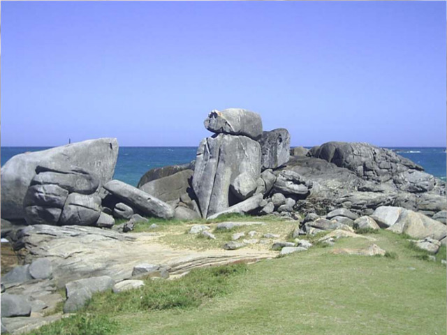
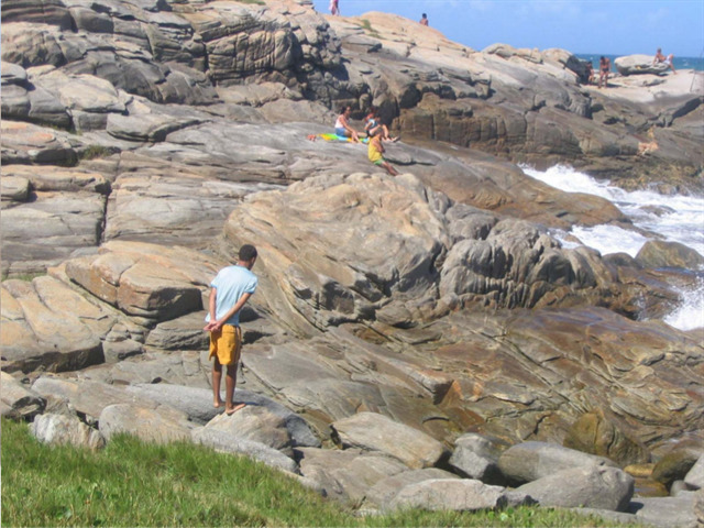
Fotos 1 e 2 - Monumento Nacional dos Costões Rochosos
QUE TIPOS DE ROCHAS FORMAM O MONUMENTO ?
O tipo de rocha predominante é o Ortognaisse (Foto 3). Para entender sua formação é preciso revisar o conceito de rocha.
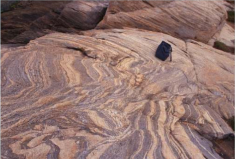
Foto 3 - Ortognaisse típico de Rio das Ostras. Note as faixas brancas (veios) intercaladas com os níveis mais escuros (ortognaisse).
As rochas são agregados de minerais consolidados, que podem ser classificadas em três grupos:
1) Magmáticas (ou ígneas) - cristalizadas devido ao esfriamento do magma (rocha fundida em temperaturas acima de 700° C).
2) Sedimentares - formadas pela deposição, soterramento, compactação e cimentação de sedimentos depositados em lagos, rios ou mares.
3) Metamórficas - rochas pré-existentes que foram submetidas a condições de temperatura e/ou pressão mais elevadas e sofreram o processo de recristalização e/ou deformação, chamado de metamorfismo.
O ortognaisse é uma rocha metamórfica com origem ígnea (indicada pelo prefixo orto). O nome gnaisse mostra que, após sua formação, as rochas foram reaquecidas e deformadas, transformando-se em metamórficas.
De uma maneira geral, esses ortognaisses apresentam-se em tons claros de rosa, bege e cinza (Foto 4). É comum observar faixas brancas fornecendo um aspecto listrado à rocha (Foto 5). Essas faixas são veios rochosos formados durante o processo metamórfico.
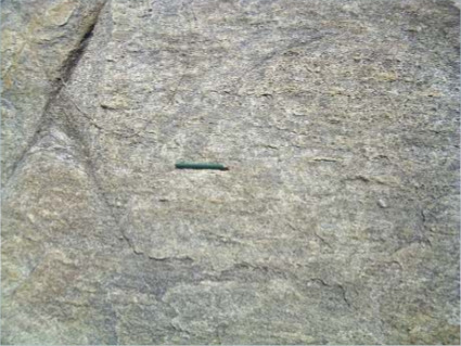
Foto 4 - Ortognaisse com tons cinza. Neste local a rocha está mais homogênea, sem veios.
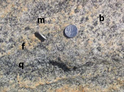
Foto 5 - Ortognaisse. Note o imã preso na magnetita (m). Os demais minerais são (b) biotita; (q) quartzo; e (f) feldspato. A moeda dá noção do tamanho dos minerais, a fim de ajudar a perceber a escala da foto.
Se examinarmos uma rocha em detalhe podemos perceber pontos de cores e brilhos diferentes: são os minerais. Os minerais são compostos sólidos naturais que apresentam uma composição química definida e com arranjo atômico regular e cristalino. Muitos minerais são microscópicos e só podem ser vizualizados com o auxílio de equipamentos (lupas ou microscópios).
Os ortognaisses de Rio das Ostras exibem muitos minerais visíveis a olho nu. Podem ser observados (veja Foto 5): (a) Quartzo - brilho vítreo e incolor; (b) Feldspato - brilho de pérola, de cor branca e rosa e forma retangular; (c) Biotita - brilho semelhante ao alumínio, cor preta e descasca em finas lâminas, ocorrendo como placas; e (d) Magnetita - brilho metálico e cor preta com forma tendendo ao hexágono. Sua principal característica é possuir magnetismo muito forte. Se você aproximar um imã da magnetita, ele será atraído.
ÁGUA MOLE EM PEDRA DURA, TANTO BATE ATÉ QUE FURA...
A esplendorosa forma dos blocos rochosos que se destaca no monumento natural é produto de milhares de anos em que as rochas estão se desestabilizando na superfície da Terra. Estes ortognaisses foram formados em níveis muito profundos, mais de 25 km de profundidade, onde a pressão é muito alta, em condições em que a temperatura ultrapassa 500° C.
Quando entram em contato com nossas condições amenas de pressão e temperatura na superfície, elas quebram e se desmancham em matacões, blocos, seixos, chegando até a grão de areia. Este processo de alteração da rocha é chamado de intemperismo.
O intemperismo é um conjunto de processos naturais físicos, químicos e biológicos que desagregam e decompõem as rochas na superfície da Terra. É também responsável por moldar a paisagem do planeta. O monumento natural de Rio das Ostras revela belas evidências deste processo.
Veja as fraturas nas Fotos 9a e 9b abaixo: com o tempo a rocha se transforma em sedimentos (material desagregado que cobre a superfície do planeta), tais como argila, areia, etc. Estes sedimentos são transportados pelos rios, ondas do mar, vento, e outros, num processo que é denominado erosão. Um dia são finalmente depositados em depressões da Terra, fundos de rio, mar, fendas, etc.
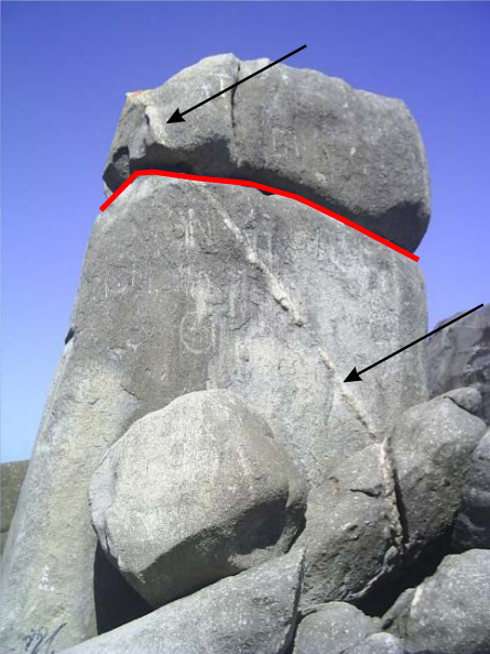
Foto 9a - O veio mais claro começa no bloco de cima e continua no bloco maior embaixo (veja as setas). A separação do veio é marcada por uma fratura (destacada na linha vermelha) que ocorre devido à desestabilização da rocha nas condições de pressão e temperatura na superfície da Terra. A tendência, com o passar do tempo, é de que o bloco superior caia e, lentamente, se desgaste até tornar-se areia de praia.
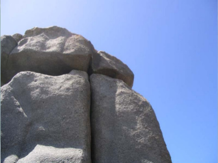
Foto 9b - Blocos arredondados que caracterizam o monumento do costão rochoso. Neste caso, as fraturas perpendiculares estão se aprofundando.
UMA HISTÓRIA DE 2 BILHÕES DE ANOS
Os ortognaisses de Rio das Ostras fazem parte de uma unidade geológica maior denominada Região dos Lagos, que ocorre nesta área.
Métodos avançados de datação revelaram sua formação há aproximadamente 2 bilhões de anos. A construção mais primitiva do Estado do Rio de Janeiro está resguardada nestas rochas. É um longo relato que se inicia com a formação da base continental, que os geólogos denominam embasamento, ou seja, as rochas mais antigas da região.
Em Rio das Ostras, foram coletadas amostras de rocha no costão da Praia da Tartaruga, onde foi encontrado o mineral zircão, excelente guia para datação. Os resultados foram surpreendentes...
Dois tipos de zircões estavam presentes (veja Foto 8): um redondo e outro alongado. Este último revelou uma idade de 1.969 milhões de anos (quase 2 bilhões de anos), relacionada aos processos de formação do embasamento. Já o zircão arredondado é bem mais jovem, 517 milhões de anos e foi encontrado nos veios (Fotos 3 e 7), o que mostra que eles se formaram depois do que o ortognaisse.
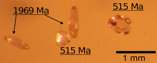
Foto 8 - Foto tirada (em lupa) dos minerais datados em Rio das Ostras, onde "Ma" = milhões de anos.
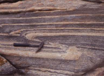
Foto 7 - Ortognaisse com veios de quartzo e feldspato. Nesses veios foram encontrados minerais mais jovens do que aqueles dos ortognaisses (veja na Foto 8). O martelo serve de escala.
Esta segunda idade registra um grande evento de colisão continental: a formação do "Himalaia Brasileiro" (veja mais detalhes em https://goo.gl/3cT72S). Este evento gerou o continente ancestral Gondwana.
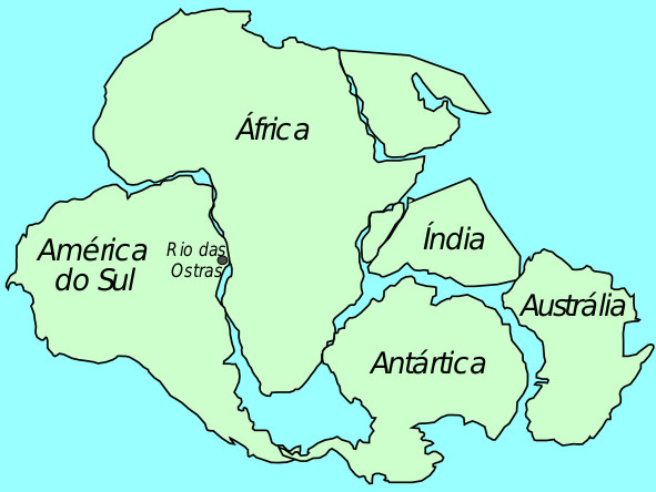
Esta fase de colisão continental, que ocorreu há 520 milhões de anos atrás, gerou o Gondwana. Somente há 130 milhões de anos, o Gondwana quebrou e deu origem aos continentes atuais da Terra. Foi nesta época que nasceu o Oceano Atlântico. Por fim chegamos à situação atual como um ecossistema costeiro.
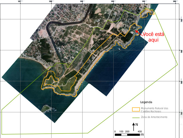
MONUMENTO NATURAL DOS COSTÕES ROCHOSOS
Área Protegida Municipal que pertence ao grupo das Unidades de Conservação de Proteção Integral, onde só são admitido usos que não envolvam coleta, dano ou destruição dos recursos naturais.
Como Monumento Natural, visa preservar um sítio natural raro de grande beleza cênica. Foi criado por um Decreto Municipal, em 2002, e compreende as praias da Joana, Brava e Areias Negras, além das ilhas do Costa, Laje Grande, Trinta Réis e dos Pombos (de acordo com informações da Prefeitura Municipal de Rio das Ostras).
Os costões rochosos, assim como as praias, dunas, lagoas, manguezais, etc., são Áreas de Preservação Permanente pela Constituição do Estado do Rio de Janeiro. Este ecossistema tem grande importância por sua alta riqueza de espécies, sendo local de sua alimentação, crescimento e reprodução.
É um ambiente especial, porque nele ocorre a transição do ambiente terrestre para o marinho. Qualquer alteração que se faça nas encostas que contribuem com sedimentos e nutrientes irá acarretar impactos negativos ao ecossistema Costão Rochoso. Desta forma, destruir as rochas e a área contígua ao costão pode provocar a destruição de muitas espécies que vivem neste ambiente de transição.
Fonte: Site do DRM-RJ.
Disponível em: https://goo.gl/3c4Y3P
<<< PERGUNTAS >>>
1 - Observe as rochas do Monumento Natural. Você acredita que elas sempre tiveram aquele formato? Se não, como você crê que aquelas grandes rochas acabaram por ganhar a sua forma atual?
2 - Ainda no local, tente encontrar as rochas mais coloridas ao redor da área deste earthcache. Observe as suas cores e os formatos nos quais elas ocorrem. O que você acha que aconteceu para que estas rochas ganhassem estas características?
3 - (Opcional) Caso você tenha imãs de diferentes tamanhos por perto, escolha algumas rochas no local e tente fazer os imãs ficarem atraídos por elas. Caso tenha sucesso, responda: qual a relação que se pode observar, entre o mineral da rocha a atrair o imã, e a intensidade da atração ?
___________________________________________________________________________
[ENG] About logging this Earthcache:
To log this Earthcache, you must complete the following steps:
- Read carefully the description of this earthcache.
- Read the questions after the description.
- Optional: Take a picture (of you or your GPS app/device) with the Monument at sight, in the background.
- Attention: Send your answers BY PRIVATE MESSAGE ONLY (clicking on the small "letter icon", right below the main title of this earthcache). Answers written directly into this very page will be removed without warning.
Link to the video of the place: https://www.youtube.com/watch?v=YggtVc2OnHA
The Natural Monument of the Rocky Coastlines are spetacular natural monuments (Pictures 1 and 2). They show a geological history of more than two billion years. As this evidence wasn't enough, the beautiful shape of the landscape holds one of the stages of the rock cycles.
The natural processes of breakdown of the rocky substracts, the weathering (alteration) and erosion transform rocks into sand beach, which, in turn, can become rock again, restarting the cycle. This exciting history is written ion the rocks, minerals and on the soil, as a recording of geological evolution of this area.
Pictures 1 and 2 - The Natural Monument of the Rocky Coastlines
WHAT KIND OF ROCKS COMPOSE THE MONUMENT ?
The predominant type of rock is the Orthogneiss (Picture 3). But, in order to understand its formation, it is necessary to review the concept of rock.
Picture 3 - Typical Orthogneiss of Rio das Ostras. Notice the white bands (veins) interspersed with the darkest levels (orthogneiss).
The rocks are aggregates of consolidated minerals, which can be classified into three groups:
1) Magmatic (or igneous) rocks - crystallized due to the cooling of the magma (molten rock at temperatures above 700 °C).
2) Sedimentary rocks - formed by the deposition, burying, compression and cementation of sediments deposited in lakes, rivers or seas.
3) Metamorphic rocks - pre-existing rocks that were submitted to higher temperature and/or pressure conditions and underwent the process of recrystallization and/or deformation, called metamorphism.
The orthogneiss is a metamorphic rock with igneous origin (indicated by the prefix ortho). The name gneiss shows that, after its formation, the rocks were reheated and deformed, being transformed into metamorphic rocks.
In general, these orthogneisses occur in light shades of pink, beige and gray (Picture 4). It is common to observe white bands giving a striped appearance to the rock (Picture 5). These bands are rocky veins formed during the metamorphic process.
Picture 4 - Orthogneiss with gray shades. At this place, the rock is more uniform, without veins.
Picture 5 - Orthogneiss. Notice the magnet stuck at the magnetite (m). The other minerals are (b) biotite; (q) quartz; and (f) feldspar. The coin is used here to give notion of the size of the minerals, enhancing the perception of scale used in the photo.
A detailled analyze of a rock allows the perception of colored points and distinct shining: those are the minerals. The minerals are natural solid compounds that have a defined chemical composition and with a regular and crystalline atomic arrangement. Many minerals are microscopic and can only be viewed with the aid of equipment (magnifying glasses or microscopes).
The orthogneisses of Rio das Ostras exhibit many minerals visible to the naked eye. Can be observed (see Picture 5): (a) Quartz - vitreous and colorless luster; (b) Feldspar - pearl glow, with white and pink colors and rectangular shape; (c) Biotite - brightness similar to aluminum, with black color and peeling on thin slides, occurring as plaques; and (d) Magnetite - metallic shine and black color with its shape tending be like an hexagon. Its main characteristic is to possess a very strong magnetism. If you approach a magnet on the magnetite, it will be attracted to it.
WATER DRIPPING DAY BY DAY WEARS THE HARDEST ROCK AWAY...
The splendorous form of the rocky blocks that stands out in the natural monument is a product of thousands of years in which the rocks are destabilizing in the surface of the Earth. These orthogneisses were formed at very deep levels, over 25 km deep, where the pressure is very high, under conditions where the temperature exceeds 500°C.
When they get in contact with our mild conditions of pressure and temperature on the surface, they break and break down into boulders, blocks, pebbles, and even a grain of sand. This process of rock alteration is called weathering.
Weathering is a set of physical, chemical, and biological natural processes that disintegrate and decompose rocks on the surface of the Earth. It is also responsible for shaping the landscape of the planet. The natural monument of Rio das Ostras reveals the beautiful evidences of this process.
See the fractures in Pictures 9a and 9b below: as time passes by, the rock turns into sediments (disaggregated material covering the surface of the planet), such as clay, sand, etc. These sediments are carried by the rivers, sea waves, wind, and others, in a process that is called erosion. One day they are finally deposited in Earth depressions, river bottoms, sea, cracks, etc.
Picture 9a - The lighter vein starts from the top block and continues on the larger block below (see arrows). The separation of the vein is marked by a fracture (highlighted by the red line) that occurs due to the destabilization of the rock in the conditions of pressure and temperature at the surface of the Earth. The tendency, over time, is for the upper block to fall and slowly wear away until it becomes beach sand.
Picture 9b - Rounded blocks featuring the rocky shore monument. In this case, the perpendicular fractures are deepening.
A HISTORY OF 2 BILLION YEARS
The orthogneisses of Rio das Ostras are part of a larger geological unit called the Região dos Lagos ("Lagos Region"), which occurs in this area.
Advanced dating methods revealed their formation approximately 2 billion years ago. The most primitive construction of the state of Rio de Janeiro is sheltered in these rocks. It is a long story that begins with the formation of the continental base, which geologists call "basement" (that is, the oldest rocks in the region).
In Rio das Ostras, samples of rock were collected on the shore of Praia da Tartaruga (Tartaruga Beach), where the mineral zircon was found, an excellent guide for geological dating. The results were surprising...
Two types of zircon were present (see Picture 8): a round one, and an elongated one. The latter revealed an age of 1.969 million years (almost 2 billion years), related to the processes of foundation formation. The rounded zircon is much younger, 517 million years old, and was found in the veins (Pictures 3 and 7), which shows that they were formed after the orthogneiss.
Picture 8 - A photo (taken in magnifying glass) of minerals dated in Rio das Ostras, where "Ma" = millions of years.
Picture 7 - Orthogneiss with veins of quartz and feldspar. Minerals younger than those of the orthogneisses were found in these veins (see Picture 8). The hammer serves as a scale.
This second age holds a registry of a major continental collision event: the formation of the "Brazilian Himalaya" (see more details at https://goo.gl/3cT72S). This event spawned the ancestral continent named Gondwana.
This continental collision stage, which occurred 520 million years ago, spawned Gondwana. Only 130 million years ago, Gondwana broke and gave birth to the Earth's present continents. It was at this time that the Atlantic Ocean was born. Then, the outcome of these changes is the present scenary of a coastal ecosystem.
THE NATURAL MONUMENT OF THE ROCKY COASTLINES
This is a protected area in the city, that belongs to the group of Conservation Units of Integral Protection, where allows only the usage of this area that do not involve collection, damage or destruction of natural resources.
In the condition of a Natural Monument, it aims to preserve a rare natural site of great scenic beauty. It was created by a Municipal Decree in 2002, and includes the beaches of Joana, Brava and Areias Negras, as well as the islands of Costa, Laje Grande, Trinta Réis and Pombos (according to the information of Rio das Ostras government).
The rocky coastlines, as well as the beaches, dunes, lagoons, mangroves, etc., are Areas of Permanent Preservation by the Constitution of the state of Rio de Janeiro. This ecosystem is highly important, due to its high richness of species, as it is also a place for its feeding, growth and reproduction.
It is a special environment, because it holds the transition from the terrestrial environment to the marine. Any change at the slopes that contribute with sediment and nutrients will have negative impacts on the rocky shore ecosystem. In this way, destroying the rocks and the area adjacent to the coast can cause the destruction of many species that live in this transition environment.
Source: DRM-RJ
Available (in portuguese) in: https://goo.gl/3c4Y3P
<<< QUESTIONS >>>
1 - Observe the rocks of the Natural Monument. Do you believe they have always been shaped in that particular format? If not, how do you believe those big rocks ended up gaining their actual shape?
2 - Still on the area, try to find the most colorful rocks around the area of this earthcache. Observe their colors and the formats in which they occur. What do you think that happened to these rocks to acquire these characteristics?
3 - (Optional) If you have access to magnets of different sizes, choose some rocks in the location and try to get the magnets attracted to them. If you are successful, answer: what is the relationship between the rock mineral attracting the magnet and the intensity of attraction?

