De visita por las maravillosas tierras asturianas visitamos los Lagos de Covadonga y encontramos por casualidad este interesante paraje y sus minas que queremos descubrir a los visitantes de esta zona.
MINAS DE BUFERRERA
Cercanas a la zona de los Lagos de Covadonga, en los aledaños del lago Enol, en medio de una zona protegida medioambientalmente hoy convertida en Parque Nacional, se encuentran los restos de una antigua e importante mina, las Minas de Buferrera.
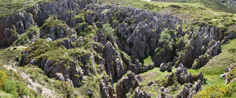
A través de una senda marcada por una pasarela de madera, en dirección contraria al lago de la Ercina, a apenas 200 m del mismo, puede verse un paisaje kásrtico, que no es producto de la naturaleza, sino de la mano del hombre, cuando en la segunda mitad del siglo XIX, en el año 1879, se crea una explotación minera de la que se extraía manganeso, hierro y cinabrio aunque principalmente se obtenía manganeso que afloraba irregularmente entre un karst de caliza, lo que ha dado lugar al increíble paisaje que puede observarse actualmente. Dichos minerales se encontraban en las grietas y oquedades de las calizas que forman los Picos de Europa en este sector.
En aquella primera época, al inicio de la época del desarrollo industrial, el mineral se extraía en cestos y se bajaba a mano y cargado en mulas hasta Covadonga, al antiguo ferrocarril que lo llevaba hasta el puerto de Ribadesella para su transporte. Sobre aquel camino que bajaba hasta Covadonga se construyó la carretera que hoy sube hasta los lagos y el ferrocarril, que hoy lleva de Arriondas a Ribadesella, hoy transporta a los que siguen la tradicional regata a la ciudad costera.
Desde Ribadesella, el mineral se cargaba en barcos hacia Francia e Inglaterra. Dada su situación geográfica estratégica, Buferrera era por entonces la principal mina europea suministradora de materiales férricos a los aliados durante la I Guerra Mundial. En aquella época llegaron a trabajar en las minas de Buferrera cerca de 500 trabajadores durante el verano, cuando la climatología permitía la explotación plena de la mina. Los mineros trabajaban en penosas condiciones y estaban poco preparados por lo que los accidentes eran abundantes. Estos mineros eran a menudo personas indocumentadas al margen de la ley por lo que los responsables de las minas se evitaban responsabilidades en caso de accidente o muerte del trabajador. Oficialmente, se tienen datos de 14 personas que murieron en las minas pero se tiene noticia de que su número fue mucho mayor. Las condiciones de trabajo eran muy duras con jornadas muy largas lo que obligaba a los mineros a exigir mejoras en las condiciones mediante protestas y huelgas. La extracción del mineral se realizaba tanto a cielo abierto como en galería. Las aguas de los lagos Enol y Ercina se empleaban en producir energía eléctrica mediante canalizaciones que transportaban el agua hasta la cercana Comeya, donde se encontraba la central eléctrica.
Al principio, el mineral era llevado a hombros o lomos de caballerías por caminos desde los lavaderos hasta Covadonga, para allí cargarse en carros de bueyes hasta Ribadesella, y desde aquí cargarse en barcos hasta Francia e Inglaterra. Más tarde, se construyó una carretera de 12,4 km desde Covadonga hasta las minas, así como un tranvía aéreo de 7 km de longitud que se inauguró en 1905, con una capacidad de transporte de 100 toneladas diarias, que unía el lavadero con el puente de Repelao, al pie de la basílica de Covadonga. A comienzos de 1899 se construyó la línea férrea por la que transcurrió un tranvía movido a vapor uniendo Torrelavega e Infiesto, con un ramal a Covadonga desde Arriondas, hoy utilizado por los visitantes al Descenso del Sella, desde Arriondas a Ribadesella. El servicio fue inaugurado oficialmente el 1 de enero de 1908, aunque el servicio regular no comenzó hasta la primavera de aquel año, debido al duro clima de que obligaba a los trabajadores de las minas a trabajar solo entre los meses de abril y octubre.
Evidentemente, en aquella época los únicos visitantes de los lagos eran los trabajadores y personal relacionado con la explotación minera, ya que los peregrinos al santuario de Covadonga sólo llegaban hasta la basílica. En aquel momento, el hoy maravilloso paisaje de los lagos era muy distinto al actual. Eran numerosos los edificios dedicados a la explotación y para los obreros y estaba compuesto, entre otros, por un almacén de comestibles, un pequeño hospital y una capilla.
La explotación minera continuó hasta el año 1958, ya que la mina era incompatible con la protección medioambiental del año 1918, cuando el rey Alfonso XIII lo declaró Parque Nacional de la Montaña de Covadonga, aunque la empresa, por aquel entonces la Compañía de Minas de Covadonga, S.A. continuó con la propiedad, y la explotación de los lavaderos de Comeya, aún ricos en mineral, no siendo hasta el año 1979 en el que, tras un contencioso con ICONA, acabó con el cierre definitivo de la mina, quedando abandonada en aquel paisaje kárstico como testigo de su antigua actividad.
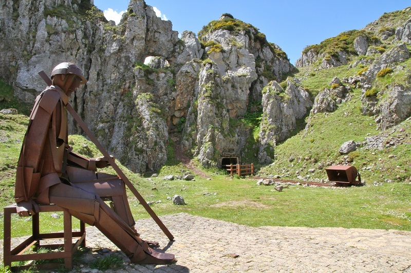
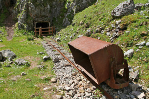
La mina ha sido rehabilitada para permitir su visita turística y pueden contemplarse las galerías, vías y transversales por las que se puede caminar. En la zona hay paneles que informan sobre las características de la explotación y de las condiciones en las que se hacían. Hoy día es difícil imaginarse aquella vieja mina en el actual paraíso natural, aunque aún se pueden ver zonas de escombros, los métodos de transporte empleados, utensilios mineros como vagonetas, raíles, etc…. Una moderna escultura en el centro de la zona representa un minero que es mudo testigo de un paisaje difícilmente inimaginable hoy en día.
El caché:
Para registrar este caché deberás contestar a las siguientes preguntas:
Waypoint 1. Coordenadas iniciales. N 43 16.455 W 004 58.838
Las coordenadas iniciales te sitúan delante de uno de los carteles informativos de la zona, el que se encuentra en la parte baja de las escaleras.
Cuestión 1. ¿Qué minerales se obtenían en estas minas? ¿De cuál de ellos se obtenía mayor producción?
Cuestión 2. ¿En las oquedades de qué tipo de roca se encontraban estos minerales en las minas de Buferrera?
Waypoint 2. N 43 16.450 W 004 58.839
Este waypoint te coloca justo al lado de la estatua del minero que se encuentra en la parte central del paraje. Desde este waypoint se pueden ver 2 entradas a las galerías de la mina.
Cuestión 3. ¿Alguna de ellas tiene salida al exterior por el otro extremo? ¿Cúal o cuáles de ellas, la situada al norte, al sur o ambas?
Cuestión 4. Entra en alguna de estas galerías y describe con tus propias palabras lo que ves en el interior de la misma.
Cuestión 5 (opcional). Hazte una foto en esta curiosa mina y envíala junto con las respuestas a las demás cuestiones sin revelar ninguna de las respuestas a las preguntas planteadas.
IMPORTANTE: Para registrar este Earthcache, por favor, enviadnos un mensaje con las respuestas a las preguntas anteriormente formuladas. Si no se cumple esto, el log podría ser borrado. No es necesario esperar a nuestra respuesta de aprobación para hacer el “found”, pero sí es necesario enviar las respuestas.
English version
Visiting the wonderful Asturian land we visited the Lakes of Covadonga and we happened to find this interesting place that we want to discover to the visitors of this area.
MINES OF BUFERRERA
Close to the area of the Lakes of Covadonga, in the vicinity of the Lake Enol, in the middle of an environmentally protected area now converted into a National Park, we can find the remains of old and important mine, the Mines of Buferrera.
Through a path marked by a wooden walkway, in the opposite direction of Lake Ercina, just 200 m from it, you can see a kartic landscape, which is not the product of nature, but the hand of man, when In the second half of the 19th century, in the year 1879, a mining exploitation was created, from which manganese, iron and cinnabar were extracted. Mainly manganese was obtained arosing irregularly between a karst of limestone, which has given rise to the incredible landscape that can be now observed. These minerals were found in the crevices and hollows of the limestones that form the Picos of Europa in this sector.
In that first period, at the beginning of the industrial development period, the ore was extracted in baskets and lowered by hand and loaded on mules to Covadonga, the old railway that took it to the port of Ribadesella for transport. On the road that went down to Covadonga, the road that today goes up to the lakes and the railroad, which today goes from Arriondas to Ribadesella, is today transported to those who follow the traditional regatta to the coastal city.
From Ribadesella, the ore was loaded on ships to France and England. Given its strategic geographical situation, Buferrera was at that time the main European mine supplying ferrous materials to the allies during the First World War. At that time, about 500 workers came to work in the Buferrera mines during the summer, when the weather allowed full exploitation of the mine. The miners worked in painful conditions and were poorly prepared, so accidents were plentiful. These miners were often undocumented persons outside the law so that those responsible for mines were avoided responsibilities in case of accident or death of the worker. Officially, there are data of 14 people who died in the mines but it is known that their number was much higher. The working conditions were very hard with very long days which forced the miners to demand improvements in the conditions through protests and strikes. The extraction of the mineral was carried out both in the open sky and in the gallery. The waters of lakes Enol and Ercina were used to produce electricity through pipelines that transported water to the nearby Comeya, where the power plant was located.
At the beginning, the ore was carried on the shoulders or backs of chivalry by roads from the washhouses to Covadonga, to be loaded in oxcarts to Ribadesella, and from here loaded on ships to France and England. Later, a 12.4 km road from Covadonga to the mines was built, as well as a 7 km long aerial tram that opened in 1905, with a transport capacity of 100 tons per day, linking the laundry with the Repelao bridge, at the foot of the basilica of Covadonga. At the beginning of 1899, the railroad line was built, through which a tram moved by steam connecting Torrelavega and Infiesto, with a branch to Covadonga from Arriondas, today used by visitors to the Descent of the Sella, from Arriondas to Ribadesella. The service was officially inaugurated on January 1, 1908, although regular service did not begin until the spring of that year, due to the harsh climate that forced mine workers to work alone between the months of April and October.
Evidently, at that time the only visitors to the lakes were the workers and personnel related to the mining, since the pilgrims to the sanctuary of Covadonga only reached the basilica. At that time, the wonderful landscape of the lakes today was very different from the current one. There were many buildings dedicated to exploitation and workers and was composed, among others, by a grocery store, a small hospital and a chapel.
The mining continued until 1958, as the mine was incompatible with the environmental protection of 1918, when King Alfonso XIII declared it Covadonga Mountain National Park, although the company, at that time the Compañía de Minas de Covadonga, SA continued with the property, and the exploitation of the Comeya laundries, still rich in mineral, not until 1979, after a dispute with ICONA, ended with the final closure of the mine, being abandoned in that karst landscape as a witness to his former activity.
The mine has been rehabilitated to allow its tourist visit and you can see the galleries, roads and crossings through which you can walk. In the zone there are panels that inform about the characteristics of the exploitation and the conditions in which they were made. Today it is difficult to imagine that old mine in the current natural paradise, although you can still see areas of rubble, the methods of transport used, mining tools such as wagons, rails, etc .... A modern sculpture in the center of the area represents a miner who is a silent witness of a landscape hardly unimaginable today.
To register this cache you must answer the following questions:
Waypoint 1. Initial coordinates. N 43 16.455 W 004 58.838
The initial coordinates place you in front of one of the information signs in the area, which is located at the bottom of the stairs.
Question 1. What minerals were obtained in these mines? Which of them gave rise to the greatest production?
Question 2. In the hollows of what type of rock minerals from Buferrera mines were found?
Waypoint 2. N 43 16.450 W 004 58.839
This waypoint places you right next to the statue of the miner that is in the central part of the place. From this waypoint you can see 2 entrances to the galleries of the mine.
Question 3. Any of them have an exit at the other end? The one to the North, the one to the South or both of them?
Question 4. Enter one of these galleries and describe with your own words what you see inside it.
Question 5 (optional). Take a picture on site (with no spoilers for the questions above) and send it along with the answers to the other questions.
IMPORTANT: To log this Earthcache, please send us a message with the answers to the questions previously formulated. If this is not true, the log could be deleted. It is not necessary to wait for our approval response to make the "found", but it is necessary to send the answers.