The purpose of this Earthcache is to provide people like me, who know very little about the environment, with an opportunity to increase their knowledge-base and to develop a deeper appreciation and respect for the world we live in. The lessons and related questions are brief, quick to answer and easy to remember for a lifetime! As with all Earthcaches, please be respectful of the land.
This Earthcache is one of four related Earthcaches that will bring you on a journey of exploration to several locations on Upper Cape Cod. Each location will introduce you to a geologically significant formation due to glacial impact.
At the time of the inception of this Earthcache, there are nine other Earthcaches located on the Cape and Islands (one of them is on Martha’s Vineyard and another on Nantucket); most of them on the outer Cape. Although it is not necessary to visit all nine (and any future additions) to get credit for this Earthcache, in doing so your experience and knowledge will only be greatly enhanced and you’ll get to visit the entire Cape. Here is the list of the nine (in no specific order):
- 1. GC5J48R Wellfleet tombolo
- 2. GC4NEZE Cape Cod Changing Glacial Bluffs
- 3. GC69K0E The Magical Quartz of Cape Cod
- 4. GC3BNDF Brrr…Harding’s Beach and Glaciers
- 5. GC19J06 Cape Cod Kettle Ponds
- 6. GCZDAZ Doane
- 7. GC1E67W Cape Cod Tidal Flats
- 8. GC7FWTQ PONDering Estuaries: Sesachacha Pond (Nantucket)
- 9. GC7ERCB Behaving ‘Erratically’ on Martha’s Vineyard
The span of time between glacial stages is called Interglacial stage. During glacial stages, the sea level would lower significantly. During interglacial periods, it would rise again due to melting ice. Both of these processes had a tremendous impact on the formation of the Cape and Islands.
The glacier reached its maximum advance somewhere around 23,000 years ago and was known as the Wisconsin Glacial Stage. Its furthest position is marked approximately by the islands of Nantucket and Martha’s Vineyard.

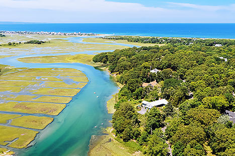
Outwash Plain: a plain formed of glacial sediments deposited by meltwater outwash at the edge of a glacier. Outwash plains are generally flat with a gradual, gentle down-slope and riddled with streams and rivers referred to as braided streams because of the zigzagging and inter-twining that was created by the escaping waters from the melting glacier. They may also present with hills known as kames and pools of water called kettles. Kames are created when outwash deposits and sediment fill a hole in the ice and it collapses into a hill shape when the ice melts. Kettle holes form when a block of ice melts and the sediments which surround the block collapse into the hole (Oldale, 2001a).
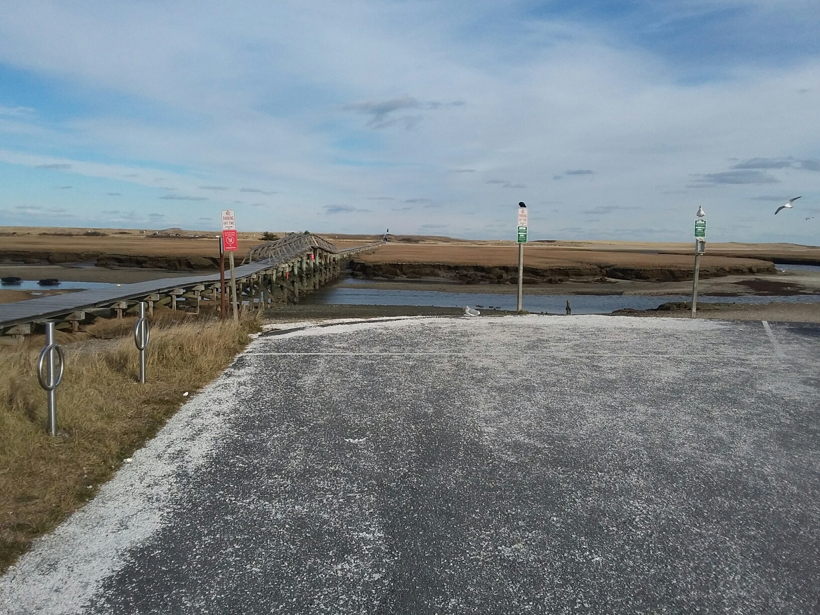
Stage One: Sandwich Outwash Plain. N 41 45.854 W 70 29.156
These coordinates will lead you to a parking lot at Sandwich’s Boardwalk Beach. [NOTE: During off-season, there is no parking fee. For 10 weeks during the summer, there is a nominal fee if you arrive between the hours of 8:30am and 4:00 pm. Parking is free if you arrive before or after that time span. The Boardwalk is about 1300 feet long, and brings you across a river and salt marshes to the ocean.] Once you arrive at the posted coordinates you will find yourself in front of a perfect and picturesque example of an outwash plain created by the retreating glacier.
The outwash plains on the upper Cape were formed in a glacial lake that occupied Nantucket Sound and Vineyard Sound. The lake was given the name Glacial Lake Cape Cod. The earliest levels of the lake ranged between roughly 80 and 50 feet above present sea level, and during these lake stages, the lake drained southward into the lowland that was to become Buzzards Bay. As the Cape Cod Bay lobe retreated northward, lower outlets were created and eventually the lake drained completely.
While at this location, be sure to look in each direction and make note of the characteristics of the terrain, especially those that define outwash plains as well as any differences or anomalies.
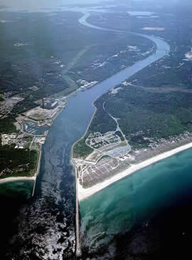
Stage Two: Cape Cod Canal. N 41° 46.395 W 070° 30.058
This set of coordinates will lead you to a public parking area adjacent to the Cape Cod Canal Welcome Center. You might be wondering what the Cape Cod Canal has to do with examining the glacial impact on the formation of Cape Cod and, specifically, outwash plains, especially since the canal is man-made. It’s simple. Were it not for the glaciers, there might possibly be no canal, or it might be in a different place on the Cape.
During the time of glacial retreat this area had an outlet that emptied into the Cape Cod Bay. This outlet was continuously lowered by erosion as the water escaped, and when the outlet was eroded to an elevation of about 30 feet, the outlet was abandoned for more favorable and effective outlets. The resulting low divide across that section of land made it the obvious location for a canal connecting Cape Cod Bay and Buzzards Bay, a conclusion reached by both Miles Standish and George Washington.
Even today, as you look at the surrounding area on either side of the canal, you will be able to see the result of the outlet erosion and outwash. And there you have it: the glacier impacted the decision to locate the canal in its current location.
Please send the CO answers to the following questions in order to earn your smiley for this Earthcache. It will not be necessary to wait for a response from him to log your find. He will contact you if there are any concerns or questions with your responses.
- Which of the descriptive characteristics of an outreach plain were clearly visible from your vantage point at the posted coordinates (look in all directions)?
- What conditions did you see at the second set of coordinates that supports the decision to have placed the canal where it is and explain, in your words, the process that occurred to create those conditions?
- OPTIONAL: Post a picture of one of the stops you made that demonstrates a geological characteristic of that location that was of interest to you and provide an explanation in your log post. It is entirely up to you whether you choose to include yourself in the photo.
Resources:
- Oldale, R. N. 2001a The Geologic History of Cape Cod, Massachusetts USGS, Woods Hole Field Center, Massachusetts. URL: http://pubs.usgs.gov/gip/capecod/index.htm
- LAURENTIDE GLACIATION OF THE MASSACHUSETTS COAST By: Margaret Martin ES 767, Quaternary Geology, Fall 2008
- Cape Cod Canal – Wikipedia