A short 1 stage Multi-Cache showing off a hidden part of Nottinghams history.

Only two parts of Nottingham’s original medieval town wall can be seen in their original positions. They are located within this hotel complex. It is thought that Nottingham’s town wall took 60 years to complete, starting around 1260. The town wall replaced 12th century earthen defenses and ditches. It extended well over 1Km, starting from Nottingham Castle’s defenses to the west, down Park Row and along Parliament street to the east. Stone gates controlled the roads into the town, at Chapel Bar, Cow Gate, St John’s Bar and Swine Bar.
The defences linked the old Anglo-Saxon town and the castle, enclosing a lower ground only occupied since the Norman Conquest (1066). There is no evidence of southern defences where the river, marsh and cliff provided natural defences. From this time until the mid 19th century, Nottingham’s physical extent remained unaltered. Much of the town wall had been demolished by 1540. Further robbing of the wall for building stones, resulted in the virtual disappearance of the town wall by the late 17th century.
The surviving medieval wall is overlain by a 19th century stone brick wall and floor. Also it is overlain by a 17/18th century brick wall, projecting at right angles from beneath the floor. The bricks have been left in place because they support the original medieval wall.
The impressive face of the wall is made of ‘ashlar’: flat faced and course blocks of local sandstone bonded with mortar. Behind the face of it, it is made of cheaper building materials. This construction method was used as it obtained the maximum effect for least cost. Irregular foundation stones at the foot of the face indicate the original ground level.
The full height of the wall may have been 8m (26ft, three times the surviving height) with a path along the top defended by battlements. A wide ditch lay along the front of the wall and an earth bank was heaped up at the back over the lower courses of the wall. At the far end of the surviving wall, a stone in the lowest course bears a incised mason’s mark which is a simple cross. Each mason had their own style of mark to show who had laid each piece of masonry work.


The town was nestled on top of a natural rise in the Sherwood Sandstones, overlooking the Trent Valley to the south. The Medieval town stretched from the ‘broadmarsh’ in the south to current day Parliament Street in the north (this street was originally called ‘backside’ – which caused great merriment in the 19th century when appalling sanitary conditions in the overcrowded Victorian town led the local MP to petition parliament to have his “backside cleaned”.
At the north side was the town wall accessed through the 'cow bar' gate along the Kings road to York. Beyond this gate were the two great arable fields of the town, the Lingdale field (later called the sand field after the soils formed from the underlying geology) and the Wood field (named after its proximity to the great wood of the town which was adjacent to it to the north east. Renamed the Clay field by the 17th century- also because of its soil from the underlying Mercia Mudstones).
At the top of the hill (at current day junction with Forest Road) stood the town Gallows- eerily overlooking the town below. A stark reminder of the cost of law breaking!!
Beyond the gallows stretched the vast heather clad Basford Waste, stretching as far as the open fields of Arnold some miles to the north. This open heathland was used by the town to graze pigs and sheep and other livestock. Beyond the waste was the great Royal deer park of Bestwood with its tall wooden fence or pale and its hunting lodge visible on top of a large hill. To the south the great meadows of the town stretched down to the banks of the Trent. These are reported as being awash with purple crocuses in the 18th century and must have been beautiful at certain times of the year.
The people of the town had the right to graze animals on the meadows in certain seasons. The town bull was also kept here.
Nottingham was divided into two parts during the medieval period. The original English town (now the lace market area) and the ‘new’ or ‘French’ town which developed as streets radiating out from the Norman castle built by William Peverill in 1067 to the west of the town. Between the two sides was the market square which would become the heart of the town over the following centuries.
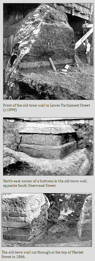
It is apparent that the building operations commenced by a juncture with the outer castle wall, and from that point were continued down what we now call Park Row, and thence along Parliament Street; the pre-existing ditch being probably at the same time re-cut, or enlarged.
At GZ go up to the steps to the glass window at the side of the hotel where you will see a section of the Medieval Wall and some Information panels.
A = How many doors can you see in the room behind the glass?
B = How many Information panels are there - times by 3.
C = What is the last number (century) to appear on the information panel "the plan and purpose of the wall" MINUS 8.
D = On the information panel "the plan and purpose of the wall", what paragraph do dates referring to "murage" grants appear.
E = On the information panel "Nottinghams Medieval town wall", how many stretches of Nottinghams Medieval town wall can still be seen in their original position?
F = What is the last number (?) to appear on the information panel "Nottinghams Medieval town wall"
The cache can be found at N52 57.ABC W001 09.DEF

You can validate your puzzle solution with certitude.