Koh Wao Waves
You will have to make your way to Koh Wao by tour or private boat. Not all operators go there so please check before you go. Please respect the National Park and do not go on the island. You will be fined by the park. You can obtain all answers offshore.
Waves are one of the most important ways that coast lines change. Winds that blow over the ocean cause waves. The wind creates friction which produces a swell. Water particles rotate inside the swell because of the energy of the wind. This moves the wave. The wave energy and size is determined by the power of the wind; the fetch (distance it has travelled) and the time the wind has been blowing.
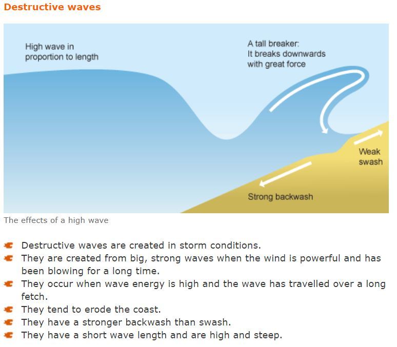
Figure 1 credit to http://www.bbc.co.uk/schools
Destructive waves erode the coast by breaking and wearing away rock. There are four types of erosion:
Solution - sea water contains acid which can dissolve limestone or chalk.
Attrition - rocks and pebbles are smashed on shore by the waves and break down into smaller, smoother pieces.
Abrasion - sand and rocks grind on other rocks and the cliff like sandpaper.
Hydraulic action - trapped air in cracks and joints compresses when it is trapped by a breaking wave and can cause erosion or weakening of the rocks.
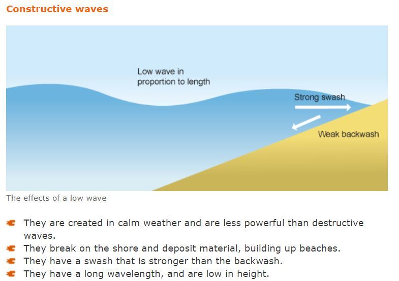
Figure 2 credit to http://www.bbc.co.uk/schools
Ocean particles are carried by rivers reaching the coast; by constructive waves moving material inland; longshore drift moves material down the coast and material can be eroded from cliffs.
Deposition of material happens when the energy is lost and the waves become constructive waves; there is a lot of material; the wave comes to a sheltered area or bay and very little wind.
To log this Earth cache please e-mail me the answers through my geocaching.com account. Once you've sent the email with your answers, go ahead and log your find without waiting for a reply from me. I will contact you if there are any problems with your log entry. Please do not give away any answers in your log or your photos!
1. What two landforms do you see on Koh Mao that have been formed by coastal processes?
2. What type of wave has had the most influence here and why?
3. Describe a swash and backwash.
4. Do you see any evidence of deposition on Koh Wao?
5. What is the average depth of the water here?
6. At Waypoint 2, describe what you see on the sea floor.
7. Why are divers not allowed in this area?
Reference:
1. http://www.bbc.co.uk/schools/gcsebitesize/geography/coasts/coastal_processes_rev2.shtml
คลื่นเกาะเวียง
คุณจะต้องเดินทางมายังเกาะเวาด้วยทัวร์หรือเรือส่วนตัว ผู้ประกอบการบางรายไม่ได้ไปที่นั่นดังนั้นโปรดตรวจสอบก่อนเดินทาง โปรดเคารพอุทยานแห่งชาติและอย่าไปเกาะ คุณอาจถูกปรับโดยสวนสาธารณะ คุณสามารถรับคำตอบทั้งหมดในต่างประเทศ
คลื่นเป็นหนึ่งในวิธีที่สำคัญที่สุดที่เส้นแนวชายฝั่งเปลี่ยนแปลงไป ลมที่พัดผ่านมหาสมุทรทำให้เกิดคลื่น ลมสร้างแรงเสียดทานที่ก่อให้เกิดอาการบวม อนุภาคน้ำหมุนภายในบวมเนื่องจากพลังงานของลม นี้จะย้ายคลื่น พลังงานคลื่นและขนาดจะถูกกำหนดโดยพลังของลม การเดินทาง (ระยะทางที่เดินทาง) และเวลาลมพัด
Khlụ̄̀n keāa weīyng
khuṇ ca t̂xng deinthāng mā yạng keāa weā d̂wy thạwr̒ h̄rụ̄x reụ̄x s̄̀wntạw p̄hū̂ prakxb kār bāng rāy mị̀ dị̂ pị thī̀ nạ̀n dạngnận pord trwc s̄xb k̀xn deinthāng pord kheārph xuthyānh̄æ̀ngchāti læa xỳā pị keāa khuṇ xāc t̄hūk prạb doy s̄wn s̄āṭhārṇa khuṇ s̄āmārt̄h rạbkhả txb thậngh̄md nı t̀āng pratheṣ̄
Figure 1 credit to http://www.bbc.co.uk/schools
คลื่นที่ทำลายล้างกัดเซาะชายฝั่งโดยการทำลายและสวมหิน มีสี่ประเภทของการกัดเซาะ:
สารละลาย - น้ำทะเลมีกรดซึ่งสามารถละลายหินปูนหรือชอล์กได้
การหักหลัง - หินและก้อนกรวดถูกทุบบนฝั่งโดยคลื่นและแตกออกเป็นชิ้นเล็กลงและเรียบขึ้น
การขัดถู - ทรายและหินโม่บนหินก้อนอื่น ๆ และหน้าผาเช่นกระดาษทราย
อากาศที่ยึดติดกับไฮดรอลิกในรอยร้าวและข้อต่อบีบอัดเมื่อมันถูกขังอยู่โดยคลื่นทำลายและอาจทำให้เกิดการกัดเซาะหรือทำให้หินอ่อนลง
Khlụ̄̀n thī̀ thảlāy l̂āng kạd seāa chāyf̄ạ̀ng doy kār thảlāy læa s̄wm h̄in mī s̄ī̀ prap̣heth k̄hxng kār kạd seāa:
S̄ārlalāy - n̂ả thale mī krd sụ̀ng s̄āmārt̄h lalāy h̄inpūn h̄rụ̄x chxl̒k dị̂
kār h̄ạkh̄lạng - h̄in læa k̂xn krwd t̄hūk thub bn f̄ạ̀ng doy khlụ̄̀n læa tæk xxk pĕn chîn lĕk lng læa reīyb k̄hụ̂n
kār k̄hạd t̄hū - thrāy læa h̄in mò bn h̄in k̂xn xụ̄̀n «læa h̄n̂āp̄hā chèn kradās̄ʹthrāy
xākāṣ̄ thī̀ yụd ti dkạbḥị dr x lik nı rxyr̂āw læa k̄ĥx t̀x bīb xạd meụ̄̀x mạn t̄hūk k̄hạng xyū̀ doy khlụ̄̀n thảlāy læa xāc thảh̄ı̂ keid kār kạd seāa h̄rụ̄x thảh̄ı̂ h̄inx̀xn lng
Figure 2 credit to http://www.bbc.co.uk/schools
มหาสมุทรอนุภาคจะดำเนินการโดยแม่น้ำถึงชายฝั่ง; โดยการสร้างคลื่นเคลื่อนที่ภายในแผ่นดิน ล่องลอยในแนวยาวเคลื่อนย้ายวัสดุลงตามชายฝั่งและวัสดุสามารถกัดกร่อนได้จากหน้าผา
การสะสมของวัสดุเกิดขึ้นเมื่อพลังงานสูญหายไปและคลื่นกลายเป็นคลื่นที่สร้างขึ้น มีวัสดุจำนวนมาก คลื่นมาถึงบริเวณที่กำบังหรืออ่าวและลมน้อยมาก
หากต้องการบันทึก Earthcache โปรดส่งอีเมลคำตอบผ่านทางบัญชี geocaching.com ของฉัน เมื่อคุณส่งอีเมลพร้อมคำตอบแล้วให้ดำเนินการต่อและเข้าสู่ระบบค้นหาโดยไม่ต้องรอคำตอบจากฉัน ฉันจะติดต่อคุณหากมีปัญหากับรายการบันทึกของคุณ โปรดอย่าให้คำตอบใด ๆ ในบันทึกหรือรูปภาพของคุณ!
Mh̄ās̄muthr xnup̣hākh ca dảnein kār doy mæ̀n̂ả t̄hụng chāyf̄ạ̀ng; doy kār s̄r̂āng khlụ̄̀n khelụ̄̀xnthī̀ p̣hāynı p̄hæ̀ndin l̀xng lxy nı næw yāw khelụ̄̀xn ŷāy wạs̄du lng tām chāyf̄ạ̀ng læa wạs̄du s̄āmārt̄h kạdkr̀xn dị̂ cāk h̄n̂āp̄hā
kār s̄as̄m k̄hxng wạs̄du keid k̄hụ̂n meụ̄̀x phlạngngān s̄ūỵh̄āy pị læa khlụ̄̀n klāy pĕn khlụ̄̀n thī̀ s̄r̂āng k̄hụ̂n mī wạs̄du cảnwn māk khlụ̄̀n mā t̄hụng briweṇ thī̀ kảbạng h̄rụ̄x x̀āw læa lm n̂xy māk
h̄āk t̂xngkār bạnthụk Earthcache pord s̄̀ng xīmel khả txb p̄h̀ān thāng bạỵchī geocaching.Com k̄hxng c̄hạn meụ̄̀x khuṇ s̄̀ng xīmel phr̂xm khả txb læ̂w h̄ı̂ dảnein kār t̀x læa k̄hêā s̄ū̀ rabb kĥnh̄ā doy mị̀ t̂xng rx khả txb cāk c̄hạn c̄hạn ca tidt̀x khuṇ h̄āk mī pạỵh̄ā kạb rāykār bạnthụk k̄hxng khuṇ pord xỳā h̄ı̂ khả txb dı «nı bạnthụk h̄rụ̄x rūpp̣hāph k̄hxng khuṇ!
1. คุณมองเห็นภูมิประเทศสองแบบบนเกาะเมียที่เกิดจากกระบวนการชายฝั่งทะเล?
2. คลื่นชนิดใดมีอิทธิพลมากที่สุดที่นี่และทำไม?
3. อธิบายสวะและล้างข้อมูลย้อนหลัง
4. คุณเห็นหลักฐานการลุกขึ้นยืนบนเกาะเวียงหรือไม่?
5. ความลึกเฉลี่ยของน้ำอยู่ที่นี่?
6. ที่ Waypoint 2 อธิบายสิ่งที่คุณเห็นบนพื้นทะเล
7. ทำไมนักดำน้ำจึงไม่ได้รับอนุญาตในพื้นที่นี้?
1. Khuṇ mxng h̄ĕn p̣hūmipratheṣ̄ s̄xng bæb bn keāa meīy thī̀ keid cāk krabwnkār chāyf̄ạ̀ng thale?
2. Khlụ̄̀n chnid dı mī xithṭhiphl māk thī̀s̄ud thī̀ nī̀ læa thảmị?
3. Xṭhibāy s̄wa læa l̂āng k̄ĥxmūl ŷxn h̄lạng
4. Khuṇ h̄ĕn h̄lạkṭ̄hān kār luk k̄hụ̂n yụ̄n bn keāa weīyng h̄rụ̄x mị̀?
5. Khwām lụk c̄helī̀y k̄hxng n̂ả xyū̀ thī̀ nī̀?
6. Thī̀ Waypoint 2 xṭhibāy s̄ìng thī̀ khuṇ h̄ĕn bn phụ̄̂n thale
7. Thảmị nạk dả n̂ả cụng mị̀ dị̂ rạb xnuỵāt nı phụ̄̂nthī̀ nī̂?
Reference:
http://www.bbc.co.uk/schools/gcsebitesize/geography/coasts/coastal_processes_rev2.shtml