Ahhh… the beaches of Australia. You’d be hard pressed to find beaches any better than those that rim this country. And the beaches of Queensland? These are some of the finest in the world.
Queensland is Australia’s northeast state and boasts a coastline stretching nearly 7000 kilometres. They say that if you “can’t find a kilometre stretch of beach with no one on it, you’re not looking hard enough.”
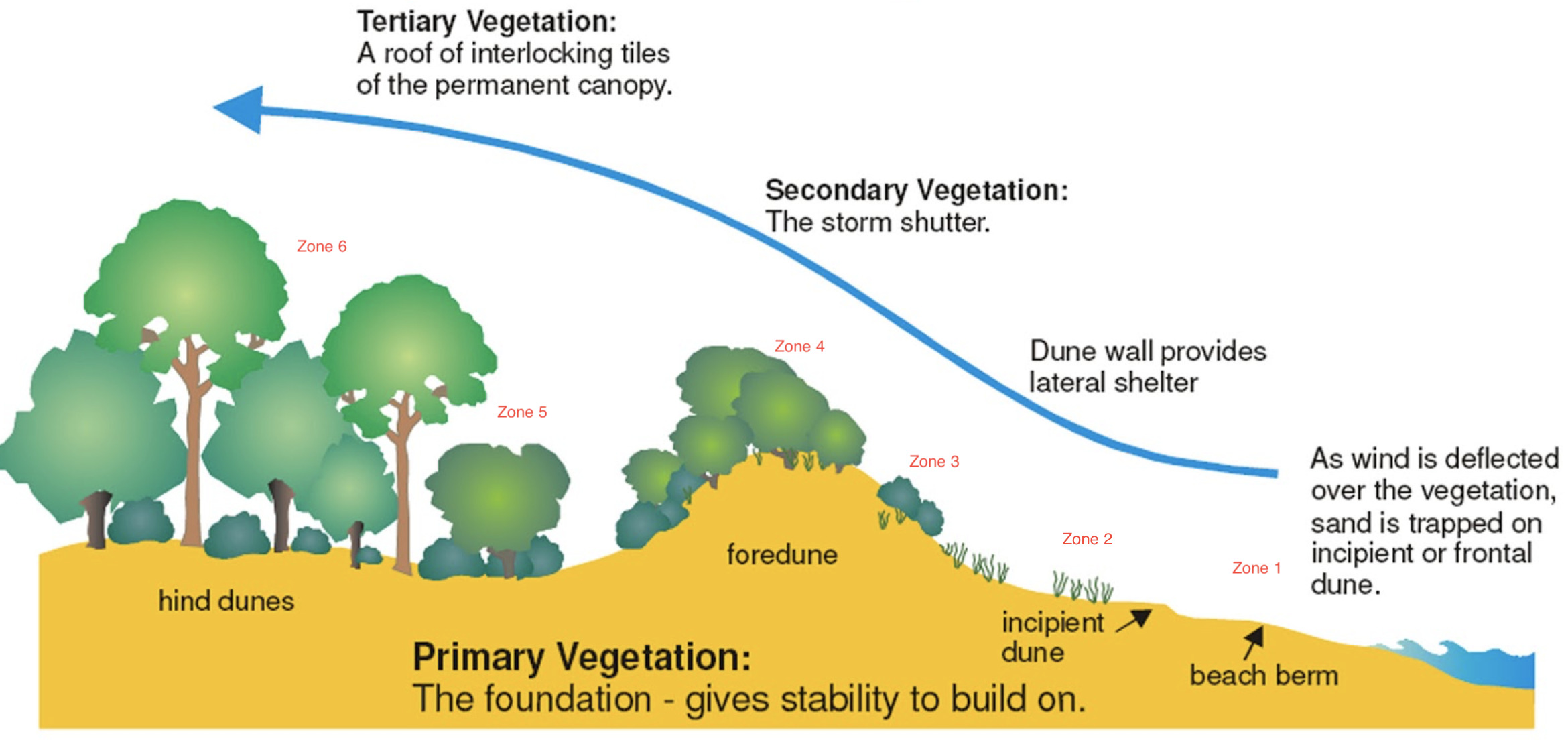
Coastal beaches and dune development, are formed with the accumulation of marine sand that is transported to the coast by waves and currents in the water. Strong winds continue to move the sand onto land and deposit it behind the beach, mostly trapping it in vegetation. It also accumulates at the bases of hills and cliffs.
In Australia there is a variety of coastal dune landforms. They range from relatively small dunes that sit immediately behind the beach, tens of metres wide and a few metres thick to large dune fields comprised of dunes that can extend several kilometres inland and can rise a few hundred metres above the shoreline representing long-term accumulation of large volumes of sand.
Vegetation immediately landward of the beach has adapted to growing in an environment that is affected by strong, salt laden winds and high sand temperatures so that most have a low-growth form and either fleshy, fairly or leathery leaves which help these plants to survive. In this exposed location, the coastal rainforest vegetation has been wind sheared by strong, salt laden winds over many years. This has created a a type of rainforest community on the top of the tertiary level.
On the western side of the dune vegetation fringing the Lagoon consists of a riparian wetland ecosystem dominated by Paperbark trees and other species of Casuarina (Casuarina glauca) which has adapted to growing in either fresh or brackish waterlogged soils.
There are six distinct zones of a Queensland coastal dune ecosystem:
- Beach: The beach has no vegetation due to the influence of strong salt laden winds and constant movement of sand caused by wind and tides
- Foredune and Swale Herbland: This zone is located immediately landward of the beach. Dominant species are low growing plants that have adapted to the stone, salt laden winds and extreme temperatures found in this hot, dry zone. Examples of some of the plants found in this zone include: Spinifex sericeus - Hairy spinifex; Canavailia rosea - Beach Bean; Carpobrotus glaucescens - Pigface; Scaevola calendulacea - Purple Fan Flower; Ipomea pes caprae - Goat’s Foot Convolvulus and Eragrostis interrupta
- Secondary Hind Dune - Casuarina Woodland: This zone is protected from severe wind erosion by the roots of trees which have adapted to growing in this wind swept environment. Ground cover plants are a mix of those found on the more exposed foredune. Some plants that may be found in this zone include: Casuarina equisetifolia - Coastal Oak; Banksia integrifolia - Coastal Banksia; Pandanus tectorius Pandanus
- Tertiary Hind dune - Low closed littoral rainforest: At this level there is little opportunity for ground cover to grow. Some plant types that may be found in this zone include: Tuckeroo, Beach Acronychia, Crab’s Eye, Coast Canthium, Black Wattle, Coastal Banksia, Bracken Fern
- Riparian wetland - Casuarina open forest/woodland: This zone is located fringing a lagoon immediately above high water level and is regionally endangered due to previous land clearing practices. Some plant types that may be found in this zone include: Swamp Oak, Broad Leaf Paperbark, Mangrove Fern
- Mangrove woodland - Coondibah Lagoon: Small patches of fringing woodland consist of species which have adapted to the brackish mud in the intertidal zone. Some types of plants found in this zone include: Grey Mangrove, Stilt Rooted Mangrove, River Mangrove, Blind-your-eye- mangrove
To claim this earthcache as a find, please send the answers to the following questions to the CO. Please do not post the answers on line.
1. At the posted coordinates, describe the ground cover, and using the ground cover as your guide, which zone of dune ecosystem do you believe GZ represents? Please explain your answer. Describe or name two plant species that may be found at this level.
2. At GZ’s posted coordinates, what is the elevation? Judging by this number, would you assume that the accumulation of sand at this location is long term or shorter term? Explain your reasoning.
3. The start of a path (Currimundi 258) to the beach area is located at Stage #2 coordinates. What is the elevation at this location? Why might this elevation be different from GZ?
4. Walk to Stage #3 coordinates along the pathway “Currimundi 258”. Describe the ground cover at the third set of coordinates. Using the ground cover as your guide, which zone do you believe this to be? Explain your answer.
5. What is the elevation at Stage #3? Describe or name two plant species that may be found at this type of dune.
***** Congratulations to Team Benders on the FTF! *****