Introduction to the volcanism of Girona comarcas
Any person uninitiated in geology knows that around the city of Olot, and in other places of the Garrotxa, there are lots of inactive volcanoes (extinct, in popular words). They are easily identifiable because of their excellent state of conservation, and they are very visited (think of the Croscat, Santa Margarida, Montsacopa...), especially since the creation of the Parc Natural de la Zona Volcànica de la Garrotxa in 1985. However, the volcanism of northeastern Catalonia is not confined solely to the Garrotxa, because there are many other eruptive manifestations difficult to recognize since they date from quite remote times.
A division can be made between two large groups of outcrops if we consider their age:
- Outcrops resulting from eruptive episodes occurring at different times of the Primary or Paleozoic era (from 570 to 245 million years ago), with remains of several types of rocks, quite poorly preserved.
- Outcrops of the Neogene and Quaternary (24 million years to this part), much more recent and in a better state of conservation.
Paleozoic volcanism
Of the volcanic eruptions of the Paleozoic epoch occurring in Girona counties, there are a series of outcrops scattered and difficult to date. As an added difficulty, we must bear in mind that many times these rocks have been affected by processes of deformation and metamorphism, which makes the study more complicated (sometimes even the microscope must be used). Geologists consider the existence, until the present moment, of three eruptive phases of this time.
- The first phase is earlier than 458 million years. You can appreciate acidic rocks (Vilamaniscle, Sant Miquel de Colera, Vilartolí) and basic (Guilleries and Cap de Creus).
- Between 458 and 448 million years there was a very intense eruptive episode, with many emissions of pyroclastic materials and, to a lesser extent, lava. Most of the remains are acidic: in the Pyrenees (Ribes de Freser and Camprodon), in the Guilleries (Sant Martí Sacalm), in the Gavarres (Sant Cebrià de Lledó) and in the Serralada de la Selva Marítima (Caulès).
- Between 296 and 286 million years the eruptions were also pyroclastic, and we can see them in Ripollès (Surroca, Ogassa and the Freser river valley).
Cenozoic Vulcanism
At the end of the Tertiary and after the rise of the Pyrenees, distant phases of the rift type affected the Girona counties. In the framework of this activity, deep flaws appeared and caused great landslides and great uprisings at the same time. Fruit of all this was the birth of the depressions of la Selva and l’Empordà (in addition to other reliefs that are in the area currently occupied by the Mediterranean Sea). These faults allowed the arrival of magmatic materials to the terrestrial surface. For this reason, volcanic outcrops are directly related to the fault situation. At first, the volcanic activity begins at the depressions of la Selva and l’Empordà, and, in the Quaternary period, continues in the pit of Olot (we must have in mind that in this area the last eruptions are dated a few millennia ago).

The distribution of volcanic outcrops by comarca (county) would be as follows:
- In l’Empordà we find a zone of sinking between the Pyrenees (N), the Sub Pyrenee-Serralada transversal (W), the Mediterranean system (S) and the Mediterranean Sea (E). The rocks that appear between the Paleogene and Neogene materials fill the depression. There are about fifty outcrops that testify the numerous lava flows and pyroclastic deposits accumulated during the upper Miocene. Unfortunately, at present we can only recognize a few, since either the erosion has dismantled the volcanic rocks, or the sedimentation has completely covered them.
- Alt Empordà. In this region, the activity developed during the upper Miocene (11,608 - 5,332 million years). This has caused that these eruptive materials are now covered by marine and continental sediments that fill the plain, which makes its location difficult. The main outcrops are in the municipal terms of Arenys d'Empordà and Vilacolum (trachytic); Castelló d'Empúries, Pedret i Marzà, Cadaqués and Llers (basaltic).
- Baix Empordà. Volcanic activity, as in the Alt Empordà, also developed during the upper Miocene; and in the same way, volcanic materials are also covered by sediments. We can find them in the municipal terms of La Pera, Foixà, Rupià, Corçà, Parlavà, Monells, Garrigoles, Torroella de Montgrí and l'Estartit.
- El Gironès. The volcanic activity of the Baix Empordà spread to the Gavarres massif also during the upper Miocene. We can find examples in Sant Martí Vell, Juià, Sant Joan de Mollet, Flaçà, Madremanya, Celrà and Girona. In el Gironès there were also eruptive phases already during the Quaternary (1,806 million years to the present), but they are circumscribed to the area of the left bank of Llémena river. They are well preserved outcrops, among which there are the volcanoes of Puig d'Adri (it produced a basaltic wash that comes very close to the city of Girona), Banya de Boc, Clot de l’Omera and Puig Moner. And at the border with the region of la Selva, highlights the volcano of the Crosa de Sant Dalmai, 43 meters deep and 1200 meters in diameter.
- La Selva. This area is situated on a plain bordered by the Montseny-Guilleries reliefs and the Gavarres massif. These volcanoes also began to develop during the upper Miocene and reached the maximum intensity during the Pliocene (5,300-2,588 million years). Filler materials are basically Pliocene detrital. Most volcanic manifestations are found on granite and metamorphic rocks. They concentrate, mainly, around Maçanet de la Selva, Sils, Riudarenes and Santa Coloma de Farners. We also find outcrops in Hostalric, Vidreres and Caldes de Malavella. Finally, near the coast, already in la Selva Marítima, we can appreciate outcrops in Tossa de Mar, Lloret and Blanes.
- La Garrotxa. In the Serralada Transversal, we can find some forty volcanic buildings in very good condition because the eruptions are more recent. These volcanic manifestations (divided between the upper basin of the river Fluvià and the medium basin of the river Ter) are located in greater quantity in the Garrotxa, but also important examples are found in the region of el Gironès. In the Garrotxa zone, volcanic activity began during the Pliocene, but reached maximum intensity during the Quaternary. It is important to know that the remains of the Pliocene are buried by the effects of the most recent eruptions. Around Olot and Santa Pau there are up to 34 volcanic buildings. In the Garrotxa depression the last known eruptions occurred some 11,000 years ago.
The vulcanism of Vall de Llémena
Most of the volcanoes that arose during the last third of the Quaternary era are located along the path of the two largest faults in the Ter River valley: the fault of Amer and the fault of Llorà. Both faults coincided in the pits of Olot and Santa Pau and the thrust fault of Vallfogona del Ripollès.
About 700,000 years ago, the first volcanic activity took place in the area of Sant Jaume de Llierca and Sant Feliu de Pallerols, in La Garrotxa. At about 550,000 years ago, the ignitions were located in the area of Batet de la Serra (between Olot, Sant Joan les Fonts, Castellfollit de la Roca and Santa Pau). It seems that the fault of Llorà is the main cause of all the fractures that are observed in the area of Serra de Batet. This fault is divided into two main branches (and many other secondary ones) at the Serra de Finestres, in direction to the north and the northwest. The volcanic zone that now occupies us, however, is the one that goes from the Serra de Finestres to the south. Here you will find an important series of volcanoes that follow the valley of the Llémena river around the area where the main point of this fault is located: the huge sinking around the town of Llorà.
The studies associate the Catalan Volcanic Zone with phenomena of what is called distensive tectonics, responsible for the formation during the Neogene and the Quaternary of the grabens of l'Empordà and La Selva and of the horsts of the Gavarres and les Guilleries The development of these structures is favored by the faults that run in NO-SE direction, which allow the rise of the magma that will end up outlining volcanoes. Examples of this would be the volcano of Puig de les Medes, related to a secondary fault of that of Amer; the Puig Moner, the Granollers de Rocacorba, the Puig de la Banya de Boc and the Clot de l'Omera, that would be related to the fault of Llorà; and lastly, that of Puig d'Adri that would be linked to the fault of Adri.
All of this area is made up of isolated magma bundles that rise rapidly and without intermediate stops from the mantle or base of the crust; once they reach the outside, the eruptions are generated, which end after the magmatic bottom has been exhausted. These type of simple eruptions are those that characterize monogenetic volcanoes. Studies in some volcanic deposits have allowed calculating the magma rise speed by about 0.2 m/s; if you take into account that in the area the thickness of the crust is about 30 km, it can be said that the magma took about a day and a half, more or less, to rise from the base of the crust until to the surface.
It is also interesting that the magma in the area was basic, that is, with little silica content, high temperature and with a small amount of primary gases; all this caused the magma to be slightly viscous, which allows us to explain the enormous mobility of lava torrents, which were able to travel long distances before solidifying: the lava flows of the volcano of Puig de les Medes traveled 5 km; that of Granollers de Rocacorba, 4; finally, that of Puig d'Adri traveled 12 km and arrived at the gates of Girona, specifically at Domeny.
Another characteristic of the magmas in the area is that they had little explosive activity and this makes strombolian activity the most present; That is the reason why many of the volcanoes in the area are of cinder con scoria type. type of cinder con scoria. with slag. In spite of everything, there are also manifestations in the area that show explosive activity, specifically of a phreatomagmatic type.
In the Llémena Valley, there are six volcanoes: Puig Moner, Granollers de Rocacorba, Puig de la banya de boc and Clot de l'omera, in the municipal district of Sant Martí de Llémena; Puig de les Medes, in Sant Aniol de Finestres; and the volcano of Puig d'Adri, in Canet d'Adri.
Can Guilana volcano
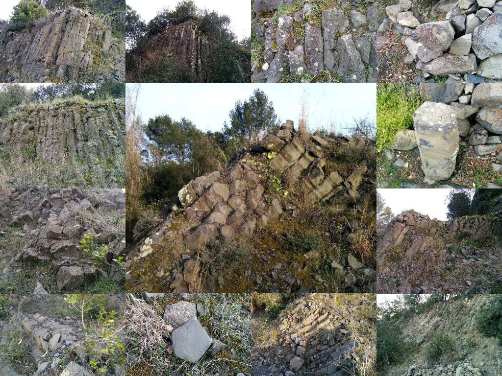
The volcano of Can Guilana is an exceptional point for the study of volcanoes. Located on a hill of an oval plant of about 350 meters in diameter and 60 meters high, unlike other nearby volcanoes that are also part of Gironès Volcanic Zone, it does not have a perfectly defined crater nor a well differentiated cone; we are actually in a volcanic fireplace filled with basalts that manifest themselves in the form of columns and lentils, surrounded by more or less cemented explosion breccias.
This volcanic outcrop is adjacent to the Puig d'Adri volcano (GC2R8XH), specifically at 6.3 km in a straight line, and has a direct relationship with it. According to scholars, the Puig d'Adri volcano has its origin in the secondary fault of Adri, born between the faults of Llorà and Cartellà. Their emissions were directed towards the east, which suggests that it originated in a collapse that occurred in the Pedret-Fontajau area.

Source: http://amigosdelosvolcanes.blogspot.com.es/p/falla-de-llora-zona-volcanica-del.html and own work.
Prior to the appearance of the volcano of Can Guilana, the Puig d'Adri volcano went alternately through five eruptive phases of different violence (moderate, ultraexplosive, moderate, ultraexplosive and newly moderated). After the last moderate phase, there was a huge reload of the system from the underground aquifers. The system was congested and in its search for a point of expansion an opening was created that allowed the reduction of the energetic tension. This opening is what we now know as the Can Guilana Volcano (in fact, scholars consider it a volcanic neck). The analysis of this spring allows us to know that it only had a stage of extreme violence during which a set of pyroclastic breccia rocks was projected on the outside. This eruptive process did not have continuity in the area of Can Guilana, but it followed through the main duct of the volcano of Puig d'Adri. This caused the chimney of Can Guilana to be completely full of lava, identical to that of the outcrop of Adri, which caused the emergence of columnar disjunctions in the mini-crater that was formed, the columns that we can see nowadays
 Current status
Although, as we have seen, this volcanic outcrop is of exceptional importance, it is not located within the Spaces of Natural Interest Plan of Catalonia (PEIN), nor is it mentioned in the Inventory of spaces of geological interest of the Generalitat de Catalunya, nor does not enjoy any special protection. Moreover, the basalts of the outcrop were used as the basis for the construction of the roads of the urbanization of the nearby golf course. The main threat, however, could come from a hypothetical expansion of this urbanization, since the volcano is located on urban land as a green area and no preservation regulations are foreseen.
Bibliography and webgraphy
Pujadas, Albert, et al. El Vulcanisme de la Vall de Llémena. Girona: Àrea de Geodinàmica de la Universitat de Girona, 1997. Col·lecció Dialogant amb pedres, 5.
Camps Gamundi, Isaac. “Volcà de Can Guilana (Gironès)” [apunt de blog]. A: Bloc De Camp [en línia], 4 Maig 2012. [Consulta: 2 d’abril de 2018; 11.14 CET]. Disponible a <http://www.blocdecamp.cat/2012/05/volca-de-can-guilana-girones.html]>.
Delabastida, Suso. “Amigos de los volcanes” [apunt de blog]. A: Zona volcànica del Gironès [en línia]. [Consulta: 2 d’abril de 2018; 11.08 CET]. Disponible a <amigosdelosvolcanes.blogspot.com.es/p/falla-de-llora-zona-volcanica-del.html>.
To register this Earthcache
Answer the questions below with a message with the Geocaching Messages center or with an email sent to xicufotsopa@gmail.com. It is not necessary to wait for my confirmation to log. If there is any problem, I will contact you. Do not hesitate to ask for help, if you need it.
- What is a monogenetic volcano?
- Which is the etymology of the word volcano?
- In the virtual stage 01 (Banc) there is a bench; with how many pieces and with what type of rock is built?
- In the virtual stage 02 (Roca) you will find two rocks.
- Explain the shape and texture of both of them.
- Estimate the approximate height and width of the largest one.
-
- What kind of rock do you think it is?
- Carbonate rock, specifically travertine.
- Detrital rock, specifically pyroclastic breccia.
- Detrital rock, specifically marlstone.
- OPTIONAL: upload a photo of you or your GPS at some zone of the volcano.
|