Logging an EarthCache requires that visitors undertake an educational task relating to the specific Earth Science at the site. If you don't want to answer the questions, don't log this EarthCache.

Murphey Candler Park Wetlands
Murphey Candler Park is a 135-acre multi-use park located in Brookhaven, Georgia. Located at the park area we find the Murphey Candler Lake that makes up a lot of the parks area.
Early in the 70’s, a flash flood caused water to flow over the Murphey Candler lake dam which caused the dam to leak. DeKalb County feared a dam failure and decided to drain the lake to make repairs. The repairs required a redirection of its water flow that was directed away from the lake. In the 90’s, due to massive construction north of the lake, the lake was then drained and dredged. It was then widened to permit more water to flow down streams.

There have been several other flash floods in the past, forcing repairs and upgrades to take place from its downstream widening, flow direction, draining and dredging work. As of 2012 the lake has now more than 6 feet of silt and no flash flood prevention other than the wood added to the guard rail on the dam to prevent cars from washing away the silt.
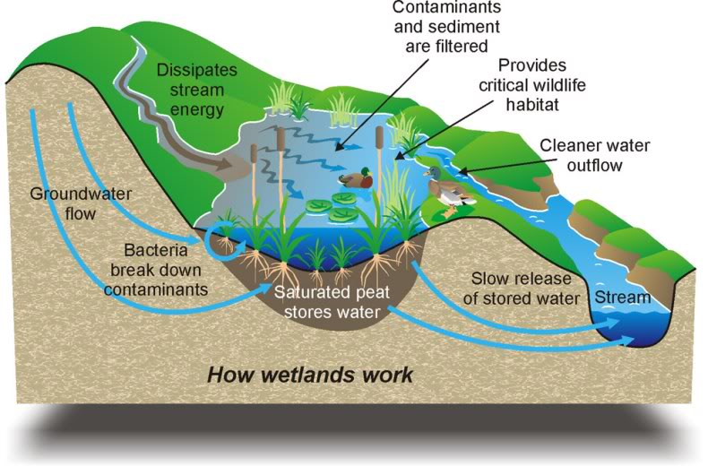
Wetlands provide important services we cannot live without. Their rich diversity of bacteria and algae break down and detoxify wastes, including oil from parking lots and chemicals produced by human activity, purifying the water we depend upon for daily life. Wetland serve as a sponge to soak up rainfall and floodwaters, slowly releasing it back to the land and keeping streams flowing even in times of drought.
What is a wetland?
Wetlands are areas where water covers the soil, or is present either at or near the surface of the soil all year or for varying periods of time during the year, including during the growing season. Water saturation (hydrology) largely determines how the soil develops and the types of plant and animal communities living in and on the soil. Wetlands may support both aquatic and terrestrial species. The prolonged presence of water creates conditions that favor the growth of specially adapted plants (hydrophytes) and promote the development of characteristic wetland (hydric) soils.
 The main wetland types include swamps, marshes, bogs, and fens. A swamp is a wetland that is forested. Many swamps occur along large rivers where they are critically dependent upon natural water level fluctuations. A marsh is a wetland that is dominated by herbaceous rather than woody plant species. Marshes can often be found at the edges of lakes and streams, where they form a transition between the aquatic and terrestrial ecosystems. A bog is a wetland that accumulates peat, a deposit of dead plant material—often mosses, and in a majority of cases, sphagnum moss. Fens are usually fed by mineral-rich surface water or groundwater. They are characterised by their water chemistry, which is pH neutral or alkaline, with relatively high dissolved mineral levels but few other plant nutrients. They are usually dominated by grasses and sedges, and typically have brown mosses in general including Scorpidium or Drepanocladus.
Geology and wetlands
Geology plays an important role in the wetland development and the characteristics listed above. Water accumulates in areas where it cannot penetrate the earth below. Some rocks, such as granite, shale and slate are naturally impervious to water. On the other hand, porous rocks can become impermeable if their pores become filled with fine particles from soil or sediments. The landscape also plays a large role in the ability of water to accumulate in an area.
There are different types of wetland landscapes that affect the drainage patterns:
- Topogenous has water movement that is predominantly vertical and overland, resulting in water ponding in depressions such as valleys, basins and floodplains (a stream, feeding a small pond or marsh with no outlet).
- Soligenous has water movement that is predominantly lateral through the soil or discharging from the rock, such as spring (water is bubbling or soaking up out of the ground).
- Flood Plain is a location where the flood rains or high waters form a wetland (an area near a stream or river).
Geology also plays a role in the chemistry of the water that flows through a wetland since the water is affected by the rocks and sediments in the area. The water that flows through a wetland is the source of nutrient elements for the plants and therefore is ultimately the basis of mineral nutrition for all inhabitants of wetlands.
Geology of Georgia
Georgia's geological history covers at least 1 billion years, and can be subdivided into five regions. The five regions are known as the:
- Coastal Plain
- Blue Ridge
- Valley and Ridge
- Appalachian Plateau
- Piedmont

The geological area where we are located is known as the Piedmont. Typical rock types that you will find in this area are schist, amphibolite, gneiss, migmatite, and granite. But the area is all composed by the three rock types: igneous, metamorphic rocks (300 to 600 million year old) and sediments (250 to 300 million years old).
The Piedmont gives home to well known features like Stone Mountain and the Brevard Fault line which runs parallel to the Chattahoochee River and bisects cities like Suwanee, Atlanta, Buford, and Duluth.
The Piedmont
The plateau region called the Piedmont is located in the eastern United States. It`s found between the Atlantic Coastal Plain and the mountain of the Appalachian. It stretches from New Jersey in the north to central Alabama in the south. The surface relief of the Piedmont is characterized by relatively low, rolling hills with heights above sea level between 50 m to 300 m. As fpr the soils and farming area, the Piedmont are generally clay-like and moderately fertile. And there are areas that have suffered from erosion and over-cropping.
The width of the Piedmont varies, being quite narrow above the Delaware River but nearly 300 miles (475 km) wide in North Carolina. The Piedmont's area is approximately 80,000 square miles (210,000 km2). The name "Piedmont" comes from the French term for the same physical region, literally meaning "foothill", ultimately from Latin "pandemonium", meaning "at the foot of the mountains", similar to the name of the Italian region of Piedmont, abutting the Alps.
Park Hours:
- The park is open Monday - Sunday: 6:00 am to 8:00 pm.
Prior to logging this cache, email the answers to the following:
- Are we located west, east, or on the Brevard Fault line?
- A wetland is an ever changing ecosystem. Describe how the wetlands appears on the day of your visit.
- Based on your observation, is this area a swamp, marsh, bog or fen?
- There are different types of wetland landscapes that affect the drainage patterns. Does this wetland have an outlet or to be a spring bubbling up in the area?
- Based on your previous conclusions would you say it is Topogenious or Soligenous?
Resources:
- USGS National Water Summary on Wetland Resources (link)
- Utah Geological Survey (link)
- U.S. Environmental Protection Agency (link)
- Biomes of Earth: Wetlands, Peter D. Moore 2006
- New Georgia Encyclopedia (link)
