There are rock formations which border Huascaran National Park (HNP). The oldest deposits date back to the Jurassic period, three of which cover most of the park. We can find sedimentary, volcanic, magnetic and intrusive rock among the formations.
Sedimentary Rock
Upper Jurassic: Outcrops are found predominantly in the central area, especially lutites with alternating sandstone layers.
Lower Cretaceous: Limonites, lutites with alternating sandstone layers are found in the southern and central-southern areas of the HNP.-In the southern area of the HNP, the bottom part of rock formations is composed of sandstone and quartzites with argillite layers, in some cases with the presence of anthracite. The upper part is composed of solid quartzites and thin layers of argillites.
Rock formations southeast to the HNP are composed of limestone and calcareous clay
Rock formations in the southeastern area of the HNP have sandstone layers and thin quartzites with alternating argillite layers
The southern area of HNP is composed of solid limestones
The southeastern area of the HNP consists of marga, a rock composed mainly from lime carbonate and clay, with alternating limestone and calcareous argillite layers.
Igneus rocks
The outcrops of this group are found in the southern area of the HNP and are composed of two units. The lower group is composed of piroplastic toba; a light, porous stone formed from lime found in water. The upper group is composed of coal briquets, gaps and lava.
Batholiths
The Cordillera Blanca batholiths are the most predominant intrusive unit in the HNP and is composed of coarse-grained granodiorite.
Educational Information:
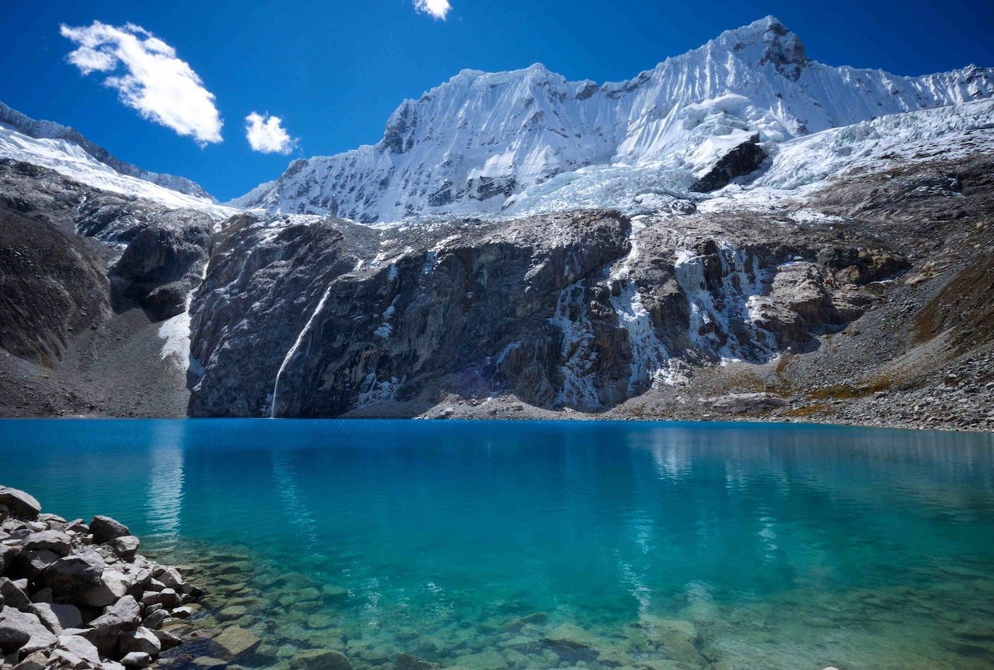
Laguna 69 is a small lake near of the city of Huaraz, in the region of Áncash, Peru. It is one of the more than 400 lakes that form part of the Huascarán National Park, a UNESCO Biosphere Reserve and World Heritage Site. In the thaw season, the lake is nourished by a waterfall from Chacraraju.
Its name is came from the fact that the lake did not have a name before the Huascaran National Park was created in 1975. The need to include all of the lakes of the proposed park into a list forced authorities to give a number-based names to those without a traditional name such as the lakes Allicocha, Auquiscocha or Palcacocha, had a names in Hispanicized Quechua).
It is one of the more important tourist destinations of the region, visited mainly by fans of hiking and mountaineering, given the simple access and the spectacular scenery. The hiking route to the lagoon starts from the Cebolla Pampa campground and runs along the brook that runs down from the same lake, and forms several waterfalls and cataracts.
To log this earthcache, please email the answers to the following questions at the same time as you log your find. If there is a problem with any of the answers. I will let you know. Found logs will be deleted if answers are not emailed at the same time.
1) At the posted coordinates look at your GPS, how high are you?
2) How does the Laguna 69 originates there?
3) What makes that unique color of the laguna?
4) Of which material the surrounding rocks exist?
5) Determine the temperature of Laguna 69?
6) Take a photo of yourself or with your GPS device at the Laguna 69!
Spanish
Hay formaciones rocosas que bordean el Parque Nacional Huascarán (HNP). Los depósitos más antiguos datan del período Jurásico, tres de los cuales cubren la mayor parte del parque. Podemos encontrar rocas sedimentarias, volcánicas, magnéticas e intrusivas entre las formaciones.
Roca sedimentaria
Jurásico superior: los afloramientos se encuentran predominantemente en el área central, especialmente lutitas con capas alternantes de arenisca.
Cretácico Inferior: Limonitas, lutitas con capas alternantes de arenisca se encuentran en las áreas sur y centro-sur de la HNP.-En la zona sur de la HNP, la parte inferior de las formaciones rocosas se compone de arenisca y cuarcitas con capas de argilita, en algunos casos con la presencia de antracita. La parte superior está compuesta de cuarcitas sólidas y capas delgadas de argilitas.
Las formaciones rocosas al sureste de la HNP se componen de piedra caliza y arcilla calcárea
Las formaciones rocosas en el área sureste de la HNP tienen capas de arenisca y cuarcitas finas con capas alternadas de argilita
El área sur de HNP está compuesta de calizas sólidas.
El área sudeste de la HNP consiste en marga, una roca compuesta principalmente de carbonato de calcio y arcilla, con capas alternadas de piedra caliza y argilita calcárea.
Rocas de Igneus
Los afloramientos de este grupo se encuentran en el área sur de la HNP y están compuestos por dos unidades. El grupo inferior está compuesto de toba piroplástica; una piedra ligera y porosa formada a partir de la cal hallada en el agua. El grupo superior está compuesto de briquetas de carbón, huecos y lava.
Batholiths
Los batolitos de Cordillera Blanca son la unidad intrusiva más predominante en la HNP y están compuestos de granodiorita de grano grueso.
Información educacional:
La Laguna 69 es una pequeña laguna cerca de la ciudad de Yungay, en la región de Áncash, Perú. Es una de las más de 400 lagunas que forman parte del Parque Nacional Huascarán, el cual es considerado Reserva de la Biosfera por la UNESCO y Patrimonio Natural de la Humanidad. En época de deshielo, la laguna se nutre mediante una catarata que cae desde el Nevado Chacraraju.
Es uno de los destinos turísticos más importantes de la región, visitada principalmente por aficionados al senderismo y montañismo, dado su sencillo acceso y las espectaculares vistas que proporciona. La ruta turística de ascenso a la laguna parte desde el camping Cebolla Pampa y sigue por el lado derecho del arroyo que baja desde la misma laguna, el cual forma varias cascadas y cataratas.
Para registrar este earthcache, envíe las respuestas a las siguientes preguntas al mismo tiempo que registra su búsqueda. Si hay un problema con alguna de las respuestas. Te lo haré saber. Los registros encontrados se eliminarán si las respuestas no se envían por correo electrónico al mismo tiempo.
1) En las coordenadas publicadas mire su GPS, ¿qué tan alto es usted?
2) ¿Cómo se origina el Laguna 69?
3) ¿Qué hace que el color único de la laguna?
4) ¿De qué material existen las rocas circundantes?
5) Determinar la temperatura de Laguna 69?
6)¡Toma una foto de ti mismo o con tu dispositivo GPS en Laguna 69!!