
The Maryland Geocaching Society welcomes you to the 2018 edition of Cache Across Maryland! This is one of eleven geocaches placed throughout the "Old Line State" in locations chosen to showcase Maryland's diverse beauty. From the mountains of Western Maryland to the Atlantic Ocean, Cache Across Maryland 2018 will once again demonstrate that Maryland truly is “America in Miniature”.
Each geocache contains a code which you will use to determine the location of the CAM 2018 Picnic to be held on May 5th, 2018. The code can be found on the inside of the cache container and on the inside front cover of the logbook. Don't forget to record this code! Any geocacher who has completed at least TEN of the eleven CAM geocaches and attends the CAM Picnic on May 5th will receive a Certificate of Completion and a Cache Across Maryland 2018 Geocoin in Antique Silver. We hope you enjoy CAM 2018!
Elk Neck State Park Arboretum Hiking Trail
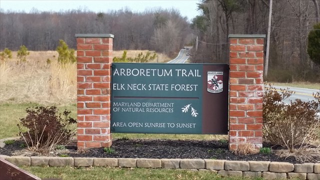
Elk Neck State Forest is home to the recently opened Arboretum Hiking Trail. In addition to being the first arboretum in Cecil County, it is the first project of its kind undertaken by the Maryland Department of Natural Resources.

Elk Neck State Forest’s Arboretum has 61 newly planted specimens and 35 pre-existing specimens on display. There are 52 different species of Maryland native shrubs and trees that are identified along the walking paths that total 1/2 mile of easily walking surfaces.
Specimens exhibit a variety of shrub and tree species from all over Maryland. Native habitat for these trees range from the mountainous Western Maryland, through the Piedmont area around Baltimore to the sandy shores of Southern Maryland and the Eastern Shore. Maryland has been described as America in miniature and through the variety of trees at the arboretum it is easy to see why.
The Arboretum is designed for use as an outdoor classroom and school groups are encouraged to take advantage of the great education opportunities. Additionally, field areas of the arboretum are being managed for wildlife habitat. Hunting during legal seasons is permitted within the designated hunting areas around the arboretum. The field and trail areas are designated as Safety Zones and excluded from available hunting acreage.
Rules of the Arboretum:
• Area is open from sunrise to sunset daily
• Area will be closed during inclement weather in accordance with State Forest inclement weather policy
• Alcohol is prohibited at the arboretum
• Area may be closed for special events, please contact office for closure dates
• School and civic groups must register with office for any activities at the arboretum due to limited parking - (410) 287-5675
• Pets are welcome, but must remain on a leash at all times. Please pick up after your pet! There are pet waste bags available for your use; please take waste with you when you leave as a part of Leave No Trace. Thank you in advance!
• Area is Trash Free. All of Maryland’s State Forest and Parks are Trash Free, so visitors are kindly asked to take out what they bring in.
The Geocache
This geocache is NOT located at the listed coordinates.
The posted coordinates will take you to an "Arboretum Information” sign with parking nearby. On the right side of the sign there are 52 common tree names numbered 1 through 52. This sign will be used to find B, C, D and E for part of the final coordinates.
The cache is located at N 39 34.ABC W 75 53.DEF.
B = "Black Cherry"
C = "American Beech" minus "Red Maple"
D = Second digit of "Southern Red Oak"
E = "Witchhazel" minus "Redbud"
At the additional waypoint (sign 2) there is a sign for "How To Plant A Tree". It will be used to find A and F for the remainder of the final coordinates.
To find the value of A, find the box on the sign labeled "Water Berm” which has a sentence "Construct a (Z)-inch high ring around the edge of the root ball to hold water", where Z is a number.
A = Z.
To find the value of F, find the box on the sign labeled "Mulch" which has a sentence that starts off "A (X)- to (Y)- inch layer applied to a large area...", where X and Y are numbers.
F = X + Y.
Checksum: A + B + C + D + E + F = 29
Sign 1 coords: N 39 34.422 W 075 52.999 (Posted)
Sign 2 coords: N 39 34.418 W 075 53.112
This geocache was placed by permission of the Maryland DNR Central Region. The MGS extends its thanks to the staff of Elk Neck State Forest for approving this cache placement.