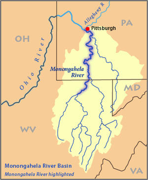
The Monongahela River
The Monongahela River, often referred to locally as the Mon, is a 130-mile-long river on the Allegheny Plateau in north-central West Virginia and southwestern Pennsylvania, which flows from south to north. The Mon river is one of about 35 other rivers worldwide that flow north and was formed some 20 million years ago. The Monongahela joins the Allegheny River to form the Ohio River at Pittsburgh. The Native American word Monongahela means "falling banks", in reference to the geological instability of the river's banks.
The Monongahela is formed by the confluence of the West Fork River and its "East Fork"—the Tygart Valley River—at Fairmont, West Virginia. The river is navigable its entire length with a series of locks and dams that maintain a minimum depth of 9 feet (2.7 m) to accommodate coal-laden barges. In southwestern Pennsylvania, the Monongahela is met by two major tributaries: the Cheat River, which joins at Point Marion, and the Youghiogheny River, which joins at McKeesport.
The upper drainage area of the river basin is renowned for its water sports/hobbies of whitewater kayaking (and in some cases whitewater rafting) opportunities. The land here is of a very rugged plateau type which allows streams to gather sufficient water volume before they fall off the plateau and create challenging rapids. Some of the best known specific stream locations for this include:
Youghiogheny River at Ohiopyle, Pennsylvania
Youghiogheny River at Friendsville, Maryland
Cheat River at Albright, West Virginia
Tygart River at Belington, West Virginia
Lake Monongahela
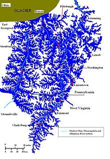
In the northern part of the State, ancient "Glacial" Lake Monongahela was formed by outwash, or possibly ice, damming the north-flowing Monongahela River and its tributaries just above the tip of the northern panhandle. This lake covered all land below 1,100 feet in elevation in parts of northern West Virginia as far south as Weston, and in southwestern Pennsylvania. It was as much as 100 miles wide (160 km) at its maximum, and its surface rose at times to 1,100 feet (340 m) above sea level. Hundreds of feet deep (~100 m) in places, its western and southern overflow gradually created the present-day upper Ohio River Valley. We can attribute the sandy and silty soils from Fairmont upstream and the varved clays in the Morgantown area to the presence of this lake.
Once Lake Monongahela formed, the water drowned the existing landforms. The lake did not erode the topography—it simply covered the land with water and lacustrine sediment. The sediment settled on both topographic highs and lows beneath the surface of the lake. Drowned terraces and abandoned meander channels, as well as low hills, slopes, and valley bottoms, received this covering of sediment. As such, sediments found on different terraces can actually be the same age. Marine (1997) found five terrace levels along the rivers, but he had to conclude that the lake deposits found on them resulted from only two episodes of glacial damming. Deposits on the fifth and fourth terrace levels represent damming during a pre-Illinoian glaciation, whereas the third- and second-terrace-level deposits represent damming during Illinoian glaciation. The first terrace (the modern floodplain) consists simply of Wisconsinan outwash and Holocene alluvial deposits, which fill river valleys that had been cut to bedrock by the end of Illinoian time.
The lakes age has been determined by the lake sediments and terrace deposits. The sediments reveal a change in the magnetic polarity during the life of the lake, with the oldest deposits being between 730,000 and 900,000 years ago. Other terrace deposits show later periods of ponding. Pollen from a pine-spruce forest dominate the oldest sediments. This reflects a climate which would have been created by the proximity of the ice sheet. Younger sediments contain pollen and plant fossils of a hemlock-hardwoods association, reflecting the moderating climate as the ice sheets retreated northward.
.
QUESTIONS!
The coordinates provided will bring you to an observation deck overlooking the river. By using your observations here and information on the cache page you can answer questions 1-4. Next, travel to the additional waypoint located not too far away; here you can answer question 5. NOTE: Please watch small children when answering question 5, as it is very close to the water. Answer each of the questions and email your findings to me via geocaching.com.
1) Approximately how old is the Mon River?
2) According to the Mon's geography and history, why do you think the river flows from south to north?
3) Describe the condition of the Mon River in front of the deck. Is it placid or swiftly flowing? What color was the water?
4) Estimate the width of the river. At GZ, is there are evidence of "falling banks" from which the river got its name?
5) Look around the park area, and even take a walk down onto the docks. Is there any evidence of silt or clay soil formed by Lake Monongahela?
Extra Credit: Take a photo of yourself at GZ. Be sure to avoid revealing too much of the answers.