From the parking lot, cross the road and take the Fall Creek Trail. The trail is a loop so it doesn't matter which way to you, but we normally go clockwise.
To get credit for this earthcache, send the answers to my geocaching account or email.
1. What color is the sandstone?
2. Are the potholes you see in the bedrock the same size or different sizes?
3. Describe in your own words how these potholes form.
4. Post a picture of yourself (face not required) or a personal item at the location.
This EarthCache will bring you to the Fall Creek Gorge Nature Preserve. Permission has been granted from The Nature Conservancy. You will walk down the trail from the parking lot to the gorge below. Do not enter the water at all! Everything is protected so you are welcome to walk around and look, but should not take anything out of the preserve or dig or excavate anything trying to view geological features.
The preserve is open to the public from dawn to dusk. While trails are developed, they are quite rugged. Please note that due to overuse of this area, the number of visitors to the site is now being limited. All visitors must park in the small parking lot on Conservancy land. Once this parking lot is full (and it can fill quickly on weekends), no further visitors are allowed. No parking is allowed on the adjacent Potholes Road, and the county rigorously enforces this ban. You will be ticketed if you park on this road!
Swimming, wading, rock climbing, rappelling, camping, campfires, alcohol and picnicking are not allowed at Fall Creek Gorge. Please carry any trash back out with you. This is a protected nature preserve and all rules must be followed.
Overview of bedrock
The Raccoon Creek Group consists of, in ascending order, the Mansfield, Brazil, and Staunton Formations, is overlain by the Carbondale Group, and is underlain by rocks ranging in age from Middle Devonian to Late Mississippian (Wier, 1970, 1986).
Shale and sandstone compose more than 95 percent of the group, and clay, coal, and limestone make up nearly all the rest; small amounts of chert and sedimentary iron ore are in the lower part of the group. Shale is more common than sandstone, and most of it is light-gray to dark-gray shale and soft non-silty shale to hard silty and sandy shale. A small amount of black fissile shale is also present. The sandstone is mostly fine grained; coarse-grained size is rare. Where the sandstone is present in the subsurface, massive cross-bedded sandstone seems to be most common.
Potholes
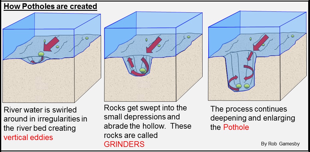
Potholes are cylindrical holes drilled into the bed of a river that vary in depth & diameter from a few inches to several feet. They’re found in the upper course of a river where it has enough potential energy to erode vertically and its flow is turbulent. In the upper course of a river, its load is large and mainly transported by traction along the river bed. When flowing water encounters bedload, it is forced over it and downcuts behind the bedload in swirling eddie currents. These currents erode the river’s bed and create small depressions in it.

The creation of eddie currents as a result of bedload in a river.
As these depressions deepen, pebbles can become trapped in them. As a result of the eddie currents, the pebbles drill into the depressions making them more circular, wider & deeper. Pebbles will only be able to erode a river’s bed though if the rock the pebble’s made of is stronger than the rock the river bed is made of.
To get credit for this earthcache, send the answers to my geocaching account or email.
1. What color is the sandstone?
2. Are the potholes you see in the bedrock the same size or different sizes?
3. Describe in your own words how these potholes form.
4. Post a picture of yourself (face not required) or a personal item at the location.