Permission from The Nature Conservancy has been granted. Goose Pond Cypress Slough is a slice of the Deep South found in southwest Indiana. The pond is actually a series of small sloughs - old side channels in the Ohio River floodplain - that run about four miles along the river. Stately bald cypress trees and cypress knees line the slough, and this preserve is perhaps the easiest place to view these unusual-to-the-state trees. Visiting this site in the wetter months can be tricky, but is definitely worth it.
No trails exist at this time, but the easy to moderate terrain is still good for hiking. Spring visits are tricky; if the Ohio River's water levels are high, the road through the preserve (and the preserve itself) is likely underwater. Midsummer (after the mud deposited from floodwaters have dried) and autumn are considered the best times to visit. During wetter times, mosquito repellant is recommended. Parking is along the side of the road.
Slough
A slough (pronounced "slew") is a wetland, usually a swamp or shallow lake, often a backwater to a larger body of water. Water tends to be stagnant or may flow slowly on a seasonal basis. In North America, "slough" may refer to a side-channel from or feeding a river, or an inlet or natural channel only sporadically filled with water. Some sloughs, like Goose Pond Cypress Slough, used to be part of the river, but have become stagnant because erosion activity changed the course of the river.
Once the river changes courses due to erosion, it will not go back to the original location. This is how the slough is formed. It will now need to be filled by rain water or flooding from the original river. Since the water will not move as much as before, the erosion process in the area will slow. What happens next will be deposition of sediment from the river flooding. This will continue to shape the slough over time.
There are four main agents of erosion. Moving water, wind, gravity, and ice wear away or break up rocks, sediments, and soil from the land's surface. When these materials are deposited or dropped in new places, it is called deposition. Erosion and deposition work together. They change landforms. Sometimes they create new ones. Flowing water wears away soil and rock like sandpaper wears away wood. Streams and rivers carve gullies and canyons through the land. Ocean waves pound rocks into small grains called sand. Wind carries away soil and sand. They are deposited in other places. Mountain glaciers slide down slopes. As they move, glacial ice plucks away soil, sediment, and rocks. Glaciers carve out mountain valleys.
Riverine swamps of bald cypress reduce damage from floods and act as sediment and pollutant traps as they cause floodwaters to spread out, slow down, and infiltrate the soil. This is one of the only locations in Indiana to have the cypress. It helps control the erosion in this area, in fact, saving the sloughs!
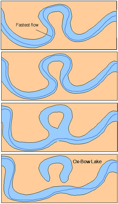
A cypress slough forms along the edge of a creek or river where it originated, sometimes as a result of the waterway changing course. When the channel meanders to the point of cutting across the curve, it is called an oxbow. During high water the stream flows through the slough, then back to the creek further downstream. Cypress sloughs drop slightly in elevation and the soil is fertile, sandy or silty loam. The dominant species, bald cypress (Taxodium distichum), often grows in standing water; can be 130 feet tall and live up to 1,200 years. With average rainfall, the slough will contain water most of the year. Upright growths called “knees” rise from cypress roots and serve an unknown purpose for the tree. Some theories suggest the knees help in aeration or serve to balance the tremendous weight of the tree in the wet soil. The bald cypress is a conifer (produces cones) with short, fine needles and small round cones. Unlike most conifers, it is deciduous since the needles drop every fall, thus, the common name “bald cypress”.
To get credit for the earthcache send the answers to my profile or email
1. How deep is the water during your visit? Why do you think this is?
2. What evidence of deposition did you see today?
3. Did you see any signs of erosion in the slough?
4. In regard to erosion and deposition, how do you think the slough will change over time?
5. Estimate the width of the slough.
6. Post a picture of yourself (face not required) or a personal item at the slough.