Grindstone Creek Floodplain
History of Hendrie Valley at the RBG
Hendrie Valley in the RBG, is named after George Hendrie, original owner, who bred horses on the land, and at the height of his cartage business owned close to 300 of them. At his Valley Farm, he invested considerable money in breeding horses, in addition to raising sheep and cattle.
Horse-breeding, grew from his cartage business, allowing him to indulge in racing and the bloodlines in his stable connected him to such international horsemen as Lord Derby and August Belmont.
In 1931, 122-acre (49 ha) parcel of the Hendrie Valley Farm was given to the City of Hamilton by George M. Hendrie. George Hendrie donated property to Hamilton Parks Board in memory of William and his brothers; ten years later it became part of newly formed RBG. The Hendrie family were founders of the Ontario Jockey Club and made their wealth in railway development. Their horse farm occupied the uplands around Hendrie Valley, and part of the horse pasture was along the floodplains in this area of Grindstone Creek, a highly fertile grassy field.
Hendrie Valley
The 100-hectare sanctuary is centered on the Grindstone Creek Valley. The area features forested slopes with towering trees, a 60-hectare river-mouth marsh complex and four creeks. Transferred to the Gardens in 1941 for ecological protection, it stretches to the end of Carroll’s Bay and contains the finest collection of floodplain wetlands on Western Lake Ontario.
Grindstone Creek is one of five creeks within the Hamilton Harbour / Burlington Bay watershed. Grindstone Creek originates above the Niagara Escarpment from the Hayesland Swamp (near Harper’s Corners in Flamborough) and follows an S-shaped path to its confluence with Burlington Bay. Shaped by glaciers, the watershed covers approximately 99 square kilometres of land and includes the urban districts of Waterdown, Aldershot and Bayview, as well as the largely rural western area of Halton Region. The Grindstone Creek watershed supplies 14 percent of the natural water into Hamilton Harbour / Burlington Bay, making it one of the main tributaries discharging into the northwest-end of Hamilton Harbour. A 50-hectare marsh lies in Hendrie Valley where the lower portion of Grindstone Creek flows. This highly productive, shallow wetland, northeast of Cootes Paradise, provides a unique environment for many plant and animal species. Grindstone Creek arises from the Hayesland Swamp and follows an S-shaped path to its confluence with Burlington Bay.
During heavy rainfalls, and spring flooding, Grindstone creek frequently rises above its banks, flooding the intermittent and perennial water bodies along its banks, dropping fertile soils that were so important to maintaining the grassy areas of the floodplain. Some areas, just up stream from this location, are much wider, flat and an open expanse of grasses, plants and small shrubs, staying dry for longer periods of time during warmer months. Areas closer to GZ, are perennial wetlands, maintaining water year round, and supporting a greater variety of flora and fauna. The boardwalk in front of you, is a bottle neck in the floodplain. Being the narrowest part of the valley, water frequently gets backed up from this point. Also having an elevation, just a few feet above lake water level, the speed of the water moving through the area slows, resulting in a slower drain from this area. During times of high lake levels, like the Spring of 2017, the water is held in the area at a much higher level.
What is a Flood Plain?
A flood plain is an area of land that is not ordinarily under water but due to a storm event may be covered with water.
During a flood, river, creek or stream water levels rise resulting in the inundation of areas not ordinarily covered by water. Such areas are known as flood plains. High water levels are often the result of extreme watercourse flows, which are produced by extreme rainfall and snowmelt.
In many areas, floods will occur because of a reduction in the natural channel capacity due to ice and debris jams. Ice and debris “block” the ability of water to move and as a result the water floods the land outside the watercourse. How extensive flooding will be in any area is determined generally through the drainage basin or watershed, and through land use.
A floodway is defined as the contiguous flood plain, whether it contains high points of land not covered by flood waters.
A flood plain consists of two parts. The first is the main channel of the river itself, called the floodway. Floodways can be an ephemeral waterbody that only exists for a short period following precipitation or snowmelt; intermittent or seasonal waterbodies, which exist for longer periods, or a perennial water body, that exists year-round.
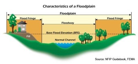
Beyond the floodway is the flood fringe. The flood fringe extends from the outer banks of the floodway to the bluff lines of a river valley. Bluff lines, also called valley walls, mark the area where the valley floor begins to rise into bluffs.
Some flood plains are extraordinarily wide, if the land is relatively flat, and the bluff lines are a significant distance away.
Other rivers have very narrow flood plains. In fact, some rivers, or parts of rivers, seem to have no flood plain at all. These rivers usually have a steep stream gradient—a very deep, fast-moving channel. and may cut it’s way through a very rocky channel, such as granite or basalt.
Geology of a Flood Plain
There are two major processes involved in the natural development of flood plains: erosion and aggradation. The erosion of a flood plain describes the process in which earth is worn away by the movement of a floodway. Aggradation (or alluviation) of a flood plain describes the process in which earthen material increases as the floodway deposits sediment.
A river erodes a flood plain as it meanders, or curves from side to side. The massive lowland flood plain of the Amazon River, for instance, is carved with hundreds of oxbow lakes that document the meandering river and its tributaries over time. Oxbow lakes are formed when a meander, or bend, in the river is cut off from the river’s main stem. Features such as oxbow lakes and seasonal wetlands are often a part of flood plains created through erosion and deposition.
A meandering stream can contribute to a flood plain’s aggradation, or build-up in land elevation, as well as its erosion.
The alluvium, or sediment, of a flood plain varies. Its coarseness and composition depend on the surrounding landscape and the velocity of the currents that created the flood plain. Some flood plains are mostly fine-grained silt, while others are sandy.
Fluvial Terraces
The sedimentary patterns of flood plains often provide scientists with evidence of past geologic activity. Thick layers of sand may indicate flash flooding, for instance, while thin, evenly spaced layers of silt may indicate more moderate and predictable flood patterns.
One of the most important geologic features of a flood plain is its fluvial terraces. Fluvial terraces are step-shaped areas of land that flank the banks of a river or stream. Fluvial terraces mark the older, higher-elevation paths of the stream, before erosion and aggredation created the current main stem of the stream or river. Fluvial terraces can mark the bluff lines—outer edges—of a flood plain.

Why are Flood Plains important?
Knowing where flood waters may rise to in the event of an extreme storm is important for land use planning and emergency management. This knowledge allows us to direct land uses away from areas of risk – areas that could be inundated with flood waters could trap people from escaping from a flooded area and could damage private property and public infrastructure.
Living in the Riparian Zone
Flood plains have dazzling arrays of biodiversity. These seasonal riparian wetlands boast greater biodiversity than the rivers themselves.
Floodplains can support particularly rich ecosystems, both in quantity and diversity. They are a category of riparian zones (an area where land and a stream overlap). A floodplain can contain 100 or even 1,000 times as many species as a river.
Agriculture
Flood plains are usually very fertile agricultural areas. Floods carry nutrient-rich silt and sediment, and distribute it across a wide area. Flood plains are flat and often have relatively few boulders or other large obstacles that may prevent farming.
Our History: Civilization Started on a Flood Plains
The three most ancient civilizations on Earth all developed on fertile flood plains. The flood plains between the Tigris and Euphrates rivers, in what are today Syria and Iraq, are known as Mesopotamia, “the land between the rivers.” Ancient civilizations of Mesopotamia include Sumeria, Akkadia, Assyria, and Babylonia. The flood plains of the Indus River, in what is today Afghanistan, India, and Pakistan, gave rise to the Indus River Civilization, also known as the Harappan civilization. Finally, ancient Egyptian culture developed around the fertile flood plains of the Nile.
In order to claim this cache as a find, send the answers to the following questions to the CO at the top of the page.
1) Is the flood way here, an ephemeral, intermittent, seasonal or perennial waterbody.
2) Standing at the posted coordinates, you are standing at a bluff wall. Walk across the boardwalk, until you reach the Bluff wall on the other side of Grindstone Creek. What is the width of the Flood Plain at this point?
3) Describe an area where you can see aggradation along the floodplain, how do you know?
4) Describe an area where you can see erosion along the Floodplain, how do you know?
Optional Questions:
5) According to the sign at GZ, what are some of the species that make this floodplain their home?
6) Describe (identify) any living organisms (including plants and wildlife) you see in the riparian zone.
7) Photos are always appreciated, (but not required) please add your photos to the cache page.
References:
Information taken from: https://www.nationalgeographic.org/encyclopedia/flood-plain/
Information taken From: https://www.ajax.ca/en/doingbusinessinajax/resources/PDENG_D_1stPIC_QuestionsandAnswers.pdf