注意事項 (Please note)
①増水している場合があります。安全を確保したうえで観察してください。
②場所によっては滑りやすくなっています。
① The amount of water in the river may be increasing. Please observe it while ensuring own safety.
②Please be careful your step, because very slippery a part of here.
雄川の河床一面に広がる「花瀬(はなぜ)の石畳」と呼ばれる岩は「溶結凝灰岩」です。
大規模な火砕流堆積物は、一般に多量の火山灰と軽石などがほぼ均一に混じり合ったもので、堆積時に低温であれば「シラス」と呼ばれる非溶結の堆積物となります。堆積物がしばらく高い温度(約700度以上)を保っていた部分は、「溶結凝灰岩」と呼ばれる特徴のある岩石となります。「溶結」とは、高温のガラス同士がくっつくようなものです。すなわち溶結凝灰岩は、高温の軽石、スコリア、火山灰などが堆積後くっつきあって生じた岩石のことを指します。
The rock which is called " The Stone pavement of Hanaze", spreads on the riverbed of Ogawa river is Ignimbrite.
Large scale pyroclastic flow deposits are generally mixed with a large amount of volcanic ash and pumice, which is a non-melt deposit, called "Shirasu", when deposited at low temperatures.The part where the deposit kept a high temperature (700℃) for a while becomes a characteristic rock called "Ignimbrite". That is, the Ignimbrite is rock that the high temperature pumice, the scoria, and the volcanic ash etc, caused after depositing and sticking.
参考:「阿蘇火山の生い立ち」渡辺 一徳 (著)、「阿蘇溶結凝灰岩」阿蘇ペディア
reference: "The history of Aso volcano" by Watanabe Kzunori, "Aso Ignimbrite" by AsoPedia
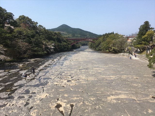
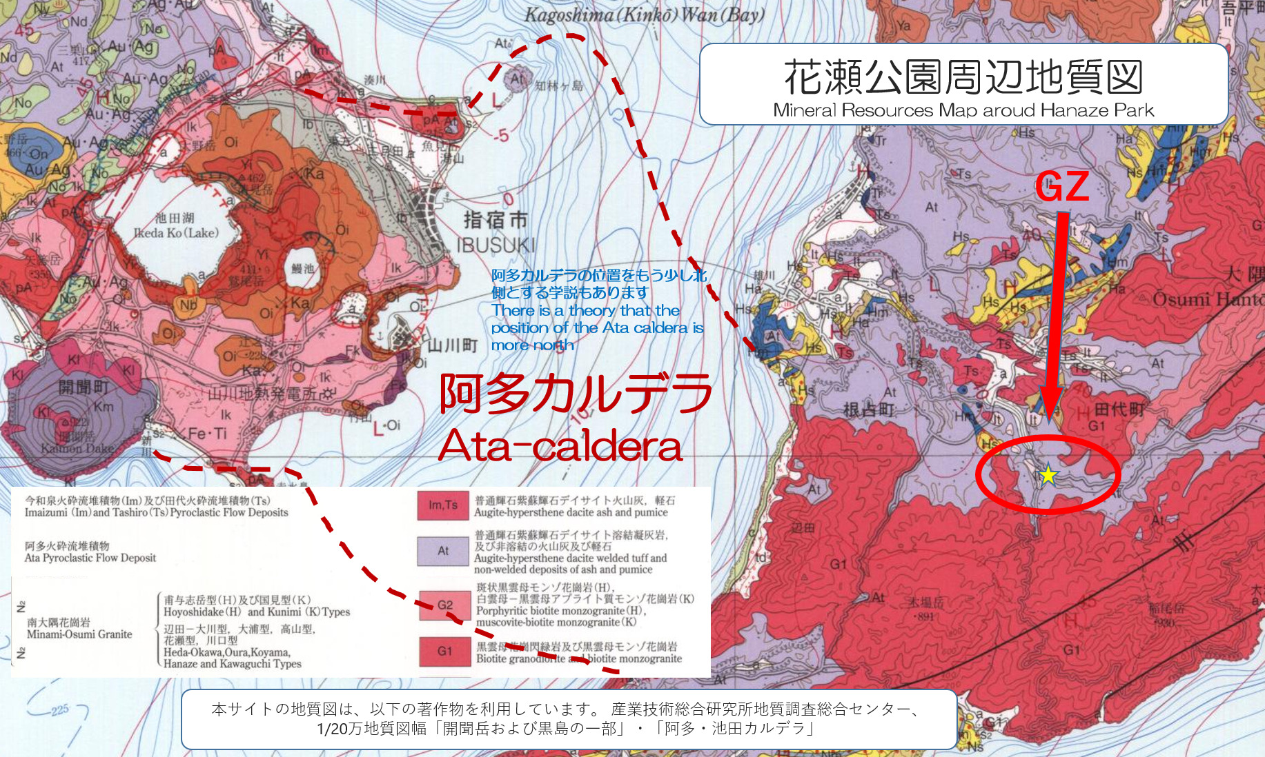
下の地質図からは、次のことを読み取ることが出来ます。①大隅半島の南東部に位置する木場岳や稲尾岳は2,330万年前に貫入した大隅花崗岩に覆われている。②それらの山に挟まれた「花瀬(はなぜ)の石畳」付近は、11万年前に繰り返し発生した「阿多火砕流」により大量の火山灰と軽石等からなる火砕流堆積物で覆われている。
From the mineral resources map below, you can read the next point. ①Mt.Kiba and Mt.Inao located in the southeastern part of the Osumi Peninsula, are coverd with the osumi granite that penetrated 23.3 million years ago. ②The vicinity of " The Stone pavement of Hanaze" in these mountains is covered with a pyroclastic flow deposit consisting of a large amount of volcanic ash and pumice, etc. by the pyroclastic flow which occurred repeatedly before 0.11 million years ago.
参考:「鹿児島の地質順序」オンライン・フィールドガイド 鹿児島、鹿児島総合研究博物館
reference: "Geological order of Kagoshima" Online:field guide Kagoshima by Kagoshima General Research Museum
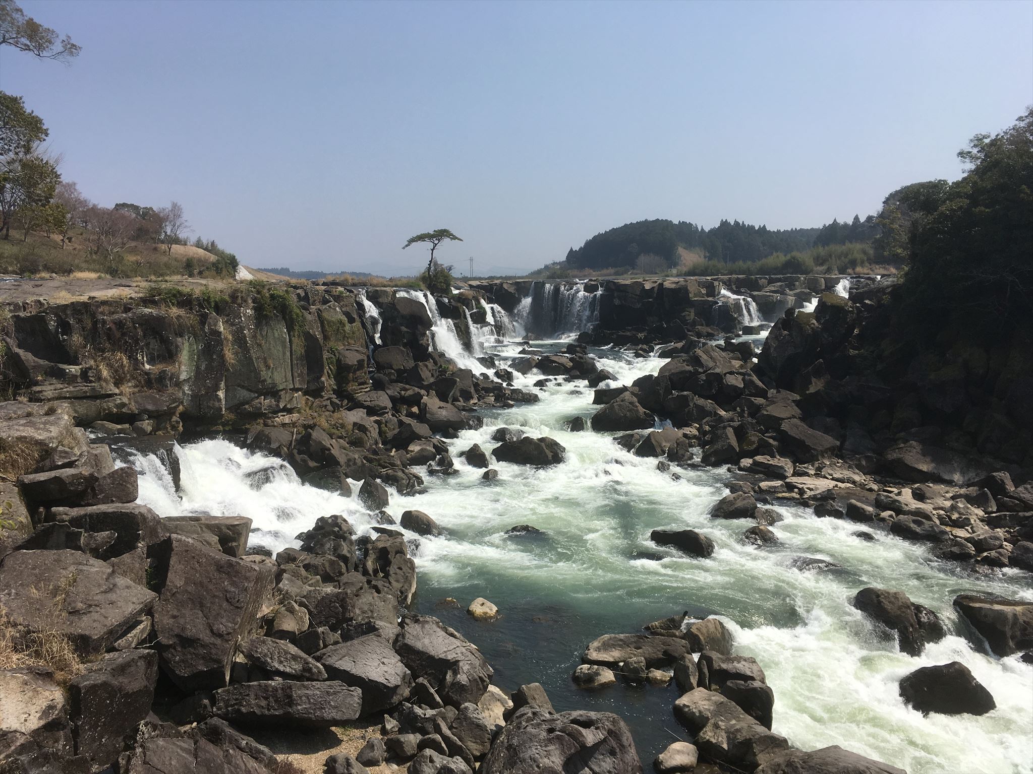
このCacheは溶結凝灰岩シリーズNo.1です。No.2「 GC7M4ZT 曾木の滝 」も訪問されることをお勧めします。溶結凝灰岩に対する理解が一層深まると思います。
This cache is Ignimbrite series No.1. I will recommend you to visit No.2 cache "GC7M4ZT Sogi Water Falls". I think that your understanding to Ignimbrite deepens further.
No.2「 GC7M4ZT 曾木の滝 」
No.2 cache "GC7M4ZT Sogi Water Falls"
1. 以下のTASKを実行してください。
2.キャッシュ名と解答をキャッシュオーナー(hikohohodemi)にメールしてください。
3. 答えはログに記入しないでください。
4.メールを送信したらファウンドログを上げてください。私の承認を待つ必要はありません。
1. Please carry out following TASK.
2. Please send e-mail this cache name and the answer to following questions to cache owner.(hikohohodemi)
3. Do not include this answer in your on-line log.
4. You do not need to wait for confirmation from me before posting online.
TASK 1
この石畳が砂岩等の堆積岩ではなく、火砕流堆積物由来のものであると分かる理由は何でしょうか?
石畳の表面を触ったり、観察してから解答してください。
What is the reason that " The Stone pavement of Hanaze" is not a sedimentary rock of sandstone, is a pyroclastic flow deposit?
Please answer, think after touching or observing the surface " The Stone pavement of Hanaze".
TASK 2
石畳にある亀裂の方向はどちらが多いですか?
次の記号の中から解答ください。例)D
A. 川の流れと並行 B. 川の流れに直角 C. どちらも同じくらい
Which is the direction of the crack in " The Stone pavement of Hanaze" ?
Please answer it from the next sign.Example) C
A. parallel to the flow of the river B. perpendicular to the flow of the river C. both
TASK 3
この場所に大量の火砕流堆積物が蓄積されたのは何故でしょうか?現地で周囲の地形を観察し、更に地質図を参考にしてその理由を述べてください。
Why did a large amount of pyroclastic flow deposit be made direct to this place?
Please refer to the local terrain and the mineral resources map to explain your thoughts.
OPTION
GZ近くで川の流れとあなた、またはあなたのGPS機器の写真を撮り、ログにアップロードしてください。但し、GZ周辺の岩のアップは写さないでください。
Please upload the photo(the flow of the river with you or your GPSr around GZ) to the log.
Don't take a picture of the surface of " The Stone pavement of Hanaze" !