History
Until the early 1950's Gifford-Hill & Co., Inc., operated a gravel and sand mining operation at this site. The lakes here are man-made and a result of open-pit excavation mining for gravel and sand, and washing the mined products. The operation was shut down via a lawsuit which alleged the operator was polluting nearby Turkey Creek, for which the town nearby is named.
Gravel is Unconsolidated, naturally occurring rounded rock fragments resulting from erosion, consisting predominantly of particles larger than sand, such as boulders, cobbles, pebbles, and granules. 1
Sand likewise is defined as Granular material resulting from rock disintegration, consisting primarily of particles having a diameter in the range of 2 mm (about the size of a pinhead) to 1/16 mm (like very fine sand paper). 1
Why here?
According to the U.S. Geological Survey, there are 35 of these such sites in Louisiana, and the majority of them are termed 'floodplain extraction activites,' meaning river deposits.2
Large hard rock resources are not naturally found at this site, but the rivers which have flowed through, over, flooded, and changed these areas geologically over the millennia have carried down all this aggregate here from naturally rocky sites north of here. This explains the roundness of the gravel you will find here. The rivers have broken them and smoothed them over during their trek down.
Characteristics
Construction sand and gravel is made up of varying amounts of different rock types and is, therefore, of varying chemical composition. Silica, or silicon dioxide (SiO2), is the major constituent of commercial sands. Lesser amounts of feldspar, mica, iron oxides, and heavy minerals are common. Industrial sand, often called silica sand, and industrial gravel differ from construction sand and gravel in that they contain high percentages of quartz, or silica, typically 95 to 99 percent.1
Quartz and quartz sand is a whitish or rose or pale pink opaque mineral. Feldspar can be similarly colored though less opaque, having better defined cleavage than quartz. The cleavage will commonly occur in two directions, usually at 90º from one another. Micas have exceptional lateral uniform cleavage, their stratification being their primary characteristic.3
You will also find a strip of crushed limestone constituting the road to this location and nearby cemetery. The limestone for the road is not from this site, and therefore isn't part of the gravel and sand aggregates making up the subject of this earth cache.
Note about site safety: You will notice nearby Posted signs pertaining to Hunting Club areas. Do not venture into those areas. Also here is Leonard Johnson Cemetery. Visit the site with reverence.
Otherwise, Leave No Trace ethics are applicable: Leave only Footprints, Take only Photographs.
Photos at the site are encouraged but not required.
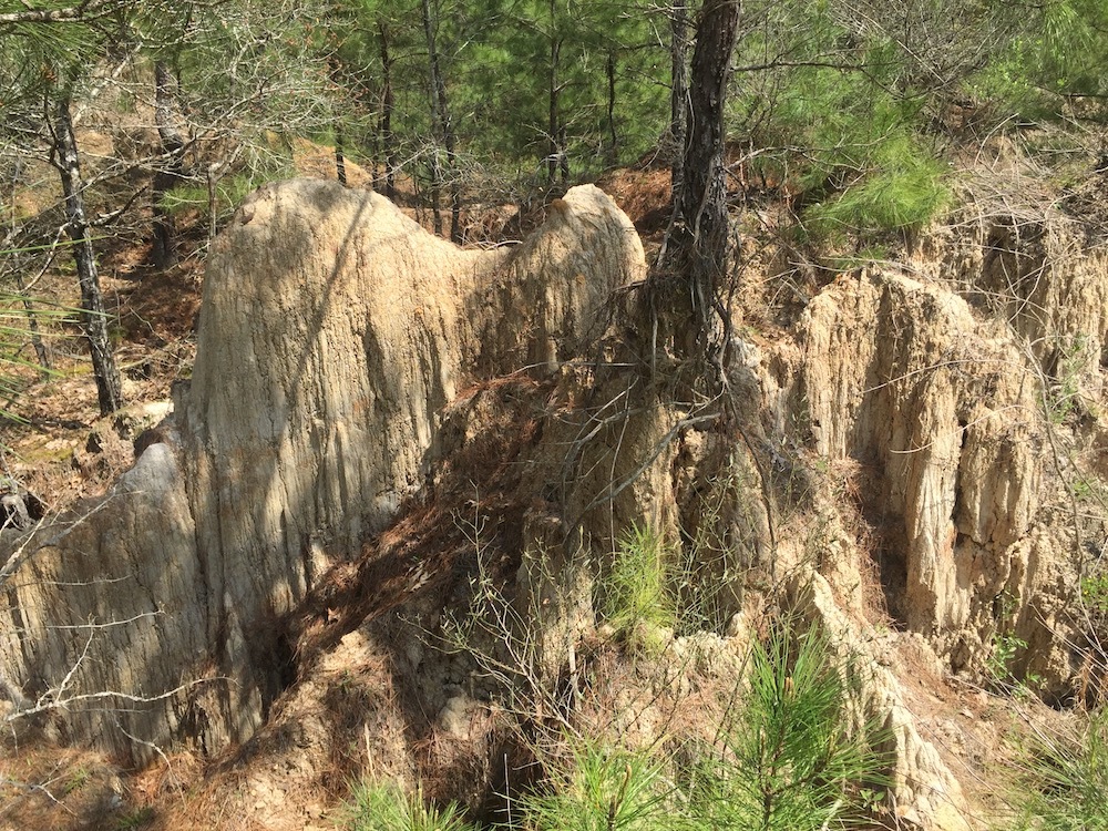
Lakes and piles of tailings ; Erosion
The mining operation dumped tons upon tons of stripped soils and sands into nearby piles, one of which is at the cache coordinates. Since the early 1950's (about 80-90 years duration) rain and vegetation has naturally eroded these piles into gnarled hills and caverns, which stand out strikingly at this location and others nearby.
The raw holes they excavated have since filled with rain water and runoff.
Answer the following questions to gain credit for the earth cache:
- What do you see more of at the earth cache coordinates, gravel or sand?
- Based on the characteristics of the minerals given above, What kind of gravel are you finding?
- Based on the amount of time since the mining operations were stopped, how long will it take for rain and vegetation erosion to completely flatten the man-made hills here?
- Observe the color of the water in the lake. Why isn't it clear?
Sources:
1. http://nonpoint.deq.louisiana.gov/wqa/links/manuals/sand_and_gravel.pdf
2. https://minerals.usgs.gov/mrerp/reports/Mossa-04HQGR0178/Mossa_Report1-04HQGR0178.pdf
3. https://geology.com/minerals/