Cette cache située sur le Chemin Hiernoulet fait partie de la balade Djan Djan à Bornivau [18] créée pour l'event les Aclot III.
Pourquoi une Earthcache sur ce parcours ? Pour vous permettre à toutes et tous de vous rendre compte qu’une Earthcache est quelque chose de simple.et que son but premier et de vous familiariser avec la géologie tout en vous adonnant à votre loisir favori.
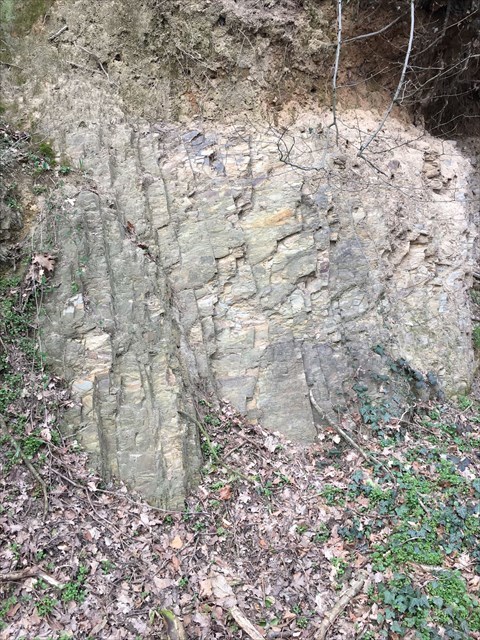
A cet endroit, vous découvrirez ce que l’on appelle en géologie un affleurement, (Partie d'un terrain visible à la surface de la terre, qui n'est pas recouvert par un sol ou de la végétation).
Beaucoup de caches dites Earthcaches vont utiliser ces affleurements comme point de départ, car ce genre de situation vous permet de facilement voir de quoi notre sol est composé.
Cet affleurement vous permet de voir un exemple de la Formation de Petit-Roeulx
Cette formation est constituée de schiste et siltite. La couleur est variable suivant l'état d'altération, allant du gris sombre à noir, à l'état frais, au jaune clair. On note la présence de minces bancs de grès.
Schiste :
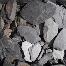
Siltite
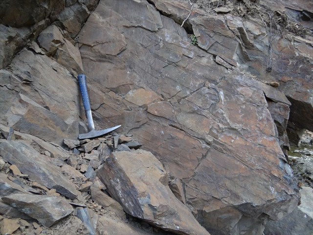
Les variations, à la fois dans l'abondance et l'épaisseur des bancs gréseux permettent de distinguer deux types extrêmes.
Dans l'un de ces types (type de la Brainette), on observe de minces lits gréseux, de quelques millimètres à 1 ou 2 cm, séparés par des passées de schiste, d'environ 10 cm à plus d'un mètre;
Dans l'autre (type de la Senne), les lits gréseux sont plus épais et plus abondants, allant de 2 à 10 cm, ils sont séparés par des passées de schiste, de 2 à 20 cm.
Le premier type est bien représenté, vers l'Ouest, dans la vallée de la Brainette, principalement aux abords de Petit-Roeulx-lez-Braine.
Le deuxième type (celui qui nous intéresse) est visible juste au Nord de la Thines, au lieu-dit «Hiernoulet», et oui nous sommes au bon endroit.
Pour votre information ou curiosité, une situation intermédiaire est visible le long du canal Charleroi Bruxelles, en face de la ferme des Chèvres.
Les roches de la Formation de Corroy se rapprochent fort de celles du type de la Senne, de la Formation de Petit-Roeulx.
A l'état frais, les schistes ont toutefois tendance à apparaître verts dans la première formation, et gris sombre dans la seconde.
La composition de la Formation de Petit-Roeulx c’est :
- Schiste : Un schiste est une roche qui a pour particularité d'avoir un aspect feuilleté, et de se débiter en plaques fines ou « feuillet rocheux ». On dit qu'elle présente une schistosité. Il peut s'agir d'une roche sédimentaire argileuse, ou bien d'une roche métamorphique.
- Siltite : Roche sédimentaire dont la granulométrie est intermédiaire entre le grès et les roches argiles. Le schiste est beaucoup plus fin
Pour logguer cette cache, vous devez répondre aux 2 questions suivantes, et optionnellement, poster une photo de vous ou de votre GPS devant l’affleurement.
Question 1 : Avec vos mots pouvez-vous dire pourquoi nous appelons ceci un affleurement ?
Question 2 : Quelles roches sont les 2 roches les plus visibles dans cet affleurement ?
Justifiez avec vos mots.
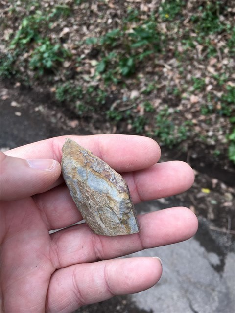
Question 3 : Sur la photo suivante, vous voyez un petit caillou provenant de cet affleurement. Pouvez-vous trouver le même type de roche et en dire plus sur sa texture ? Est-il rugueux, lisse, cassant, dur, coupant, ... et à votre avis de quelle pierre s'agit-il ?
Question 4 : (OPTIONNEL) faites une photo de vous et/ou de votre GPS devant l’affleurement.
Envoyer moi les réponses via la messagerie Géocaching, et loguer immédiatement. Je vous recontacte si les réponses ne sont pas correctes.
English version
This cache located on Chemin Hiernoulet is part of the ride Djan Djan Bornivau [18] created for the event the Aclot III.
Why an Earthcache on this course? To allow you all to realize that an Earthcache is something simple and its primary purpose and to familiarize you with geology while indulging in your favorite hobby.
At this point, you will discover what is called in geology an outcrop, (Part of land visible on the surface of the earth, which is not covered by soil or vegetation).
Many Earthcache caches will use these outcrops as a starting point, because this kind of situation allows you to easily see what our soil is made up of.
This outcrop allows you to see an example of the Petit-Roeulx Formation
This formation consists of shale and siltite. The color is variable depending on the state of weathering, ranging from dark gray to black, fresh, light yellow. We note the presence of thin sandstone benches.
Schist:
Siltstone
Variations in both the abundance and thickness of sandstone beds distinguish two extreme types.
In one of these types (type of Brainette), thin sandstone beds are observed, from a few millimeters to 1 or 2 cm, separated by shale past, from about 10 cm to more than one meter;
In the other (Senne type), the sandstone beds are thicker and more abundant, ranging from 2 to 10 cm, they are separated by shale past, from 2 to 20 cm.
The first type is well represented, towards the West, in the Brainette valley, mainly near Petit-Roeulx-lez-Braine.
The second type (the one we are interested in) is visible just north of Thines, at a place called "Hiernoulet", and yes we are in the right place.
For your information or curiosity, an intermediate situation is visible along the Brussels Charleroi canal, in front of the Goat farm.
The rocks of the Corroy Formation are very close to those of the Senne type, the Petit-Roeulx Formation.
In the fresh state, however, shales tend to appear green in the first formation, and dark gray in the second.
The composition of the Petit-Roeulx Formation is:
- Shale: A shale is a rock that has the particularity of having a laminated appearance, and to be sold in thin slabs or "rocky sheet". It is said to have schistosity. It may be a clayey sedimentary rock, or a metamorphic rock.
- Siltite: sedimentary rock whose granulometry is intermediate between the sandstone and the clay rocks. Shale is much thinner
To log this cache, you must answer the following 2 questions, and optionally post a photo of you or your GPS in front of the outcrop.
Question 1: With your words can you say why we call this an outcrop?
Question 2: Which rocks are the 2 most visible rocks in this outcrop?
Justify with your words.
Question 3 : In the next picture, you see a small pebble coming out of this outcrop. Can you find the same type of rock and say more about its texture? Is it rough, smooth, brittle, hard, sharp, ... and in your opinion what stone is it?
Question 4: (OPTIONAL) take a picture of yourself and / or your GPS in front of the outcrop.
Send me the answers via Geocaching messaging, and log immediately. I'll get back to you if the answers are not correct.