 Direkter Zugriff auf die deutsche Version. Vielen Dank an KERSEN22 für die Übersetzung
 Directe toegang tot de Nederlandse versie. Bedankt KERSEN22 voor de vertaling
 Direaccess to the English version


Il n’y a pas de Boîte à cette cache.
Cette Earthcache est la suite du descriptif plus général du : Poudingue de Malmedy.
Pour cette cache, je vous propose d’approfondir les explications des phénomènes karstiques du Poudingue. Cela n'est pas indispensable, mais avant cela, je vous conseil de comprendre les explications de la 1° Earthcache.
En vous vous rendant sur place, vous ne trouverez pas de panneau explicatif, mais répondez aux questions suivantes :
- Comment se sont crées les grottes, réseaux souterrain, etc..?
- Quelles sont les deux particularités géologiques du Poudingue de Malmedy ?
Et voici les question squi me prouveront que vous vous êtes rendu sur place, aux coordonnées de l’Earthcache, à l’aide des explications du descriptif, pourriez-vous me dire :
- Quelle est la couleur dominante du ciment du poudingue ?
- Essayez de trouver la dureté sur l’échelle de Mohs, avec une pièce de 1 Eurocent, frottez la pièce sur le poudingue, vous observez quoi ? – expliquez cette réaction.
- Derrière le grillage, au ras du sol, que pouvez-vous observer ?
- Une photo de vous, sur les lieux de la cache, fais toujours plaisir, mais facultative.
Loguez cette cache "Found it" et envoyez-moi vos propositions de réponses soit via mon profil, soit via la messagerie geocaching.com (Message Center), et je vous contacterai en cas de problème. N’inscrivez pas les réponses dans votre log.
Définition simplifié d’un phénomène karstique :
Le karst est une structure géomorphologique résultant de l'érosion hydro chimique et hydraulique de toutes roches solubles, principalement de roches carbonatées dont essentiellement des calcaires.
Les karsts présentent pour la plupart un paysage tourmenté, un réseau hydrographique essentiellement souterrain (rivières souterraines) et un sous-sol creusé de nombreuses cavités : reliefs ruiniformes, pertes et résurgences de cours d'eau, grottes et gouffres.
Trois assises de nature différentes dans ce poudingue
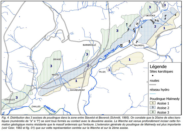
Au sein du Poudingue de Malmedy, on distingue 3 assises avec chacune leurs caractéristiques propres. De bas en haut, on a successivement :
- La 1ère assise (inférieure) présente un poudingue à ciment argileux, majoritairement de couleur rouge, emprisonnant des galets de roches ardennaises (grès, quartzite, quartzophyllade, schiste et arkose), d’un diamètre pouvant atteindre 16cm à Malmedy. La partie inférieure qui présente des bancs de schiste. La puissance (l’épaisseur) de cette 1ère assise atteint environ 60 m à Malmedy, et se réduit à 15m à Stavelot.
- La 2ème assise (moyenne ou médiane) est celle où se concentrent les phénomènes de type karstique. Le poudingue y est composé d’un ciment calcaro-argileux, emprisonnant des galets de calcaire, mélangés avec d’autres en grès, quartzite et quartzophyllade. Epaisse d’environ 150m à Malmedy, à Stavelot elle est de 30m, avant d’augmenter ensuite pour atteindre 70m à Basse-Bodeux.
Les galets calcaires, souvent fossilifères, seraient en majorité issus des calcaires du Dévonien moyen de l’Eifel, dans la région de Prüm, une cinquantaine de km plus à l'est, et très probablement amenés dans cette cuvette de Malmedy par un cours d'eau, en condition semi-désertique avec des crues subites capables de transporter des blocs de grande taille (atteignant 30cm de diamètre à Bevercé) !
La proportion de galets calcaires au sein du poudingue diminue du nord-est au sud-ouest : à Malmedy, ils représentent 60% du total, contre 39% à Basse-Bodeux, et seulement 26% à l’extrémité ouest de cette zone.
La diminution de la grosseur des galets, toutes natures confondues, suit cette même distribution : de 30cm à Bévercé, ils sont inférieurs à 10cm à Basse-Bodeux. Dans cette dernière zone, là où le poudingue se compose de galets moins nombreux et plus petits, avec plus de bancs de psammite intercalés, cette roche a pu être utilisée comme matériau de construction, comme on peut le voir sur les bâtiments anciens du village.
- La 3ème assise (supérieure) présente un poudingue à ciment argileux, ne contenant que des galets mal émoussés issus de roches locales (phyllade, quartzite, grès). Elle est présente à Malmedy pour 30m d’épaisseur et à Stavelot.
Pour bien comprendre comment se présentent ces 3 assises au sein de la bande de poudingue permien, il faut encore préciser que cet « empilement » n’est pas horizontal, mais présente majoritairement un pendage vers le nord-ouest.
Voilà pourquoi, si on traverse la bande de poudingue là où les 3 assises sont présentes (région de Bévercé par exemple), du sud-est vers le nord-ouest, on traversera d’abord une zone de poudingue de la 1ère assise, puis le poudingue en partie calcaire de la 2ème assise et enfin celui de la 3ème assise.
Extension du karst dans le massif de Stavelot
La présence de calcaire dans le Poudingue de Malmedy est une particularité unique au sein du massif de Stavelot, dont les autres roches constitutives sont toutes dépourvues.
C'est dans les affleurements de la 2ème assise que se concentrent les phénomènes karstiques. C’est là où cette assise est la plus épaisse et la plus riche en calcaire que l’on retrouve le plus de phénomènes karstique.
Les eaux de ruissellement, provenant des terrains cambriens dépourvus de calcaire (donc relativement acides et agressives), s'écoulent vers le poudingue calcareux.
Le contact d’eau de ruissellement-roche carbonatée est ici favorisé par la fracturation importante du poudingue, sous forme de nombreuses cassures verticales.
Comparaison avec un “karst classique”
Contrairement aux karsts "actifs" traditionnels, les sites karstiques semblent se développer plus lentement et de façon moins "spectaculaire" dans le Poudingue de Malmedy.
La composition géologique de ce conglomérat va déterminer la solubilité de ces différents composants: les galets calcaires sont les plus sensibles à la corrosion, suivis du ciment du poudingue et des bancs intercalaires de psammite. Ces deux derniers, partiellement composés de calcaire, ne seront que partiellement dégradés.
Enfin, les galets non calcaires sont insensibles à la dégradation chimique par l’eau. Une fois détachés des parois par l’érosion mécanique, ceux-ci vont s’accumuler à la base des puits et galeries, en l’absence de courant d'eau suffisant pour les évacuer vers l’extérieur.
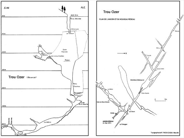
L’exploration des cavités du poudingue nécessite l’usage de cordes car les réseaux souterrains y sont majoritairement verticaux (le trou Ozer atteignant 70m de profondeur, probablement lié à l'encaissement de la Warche).
Ces cavités se sont formées par élargissement de diaclases via la dissolution et l’érosion mécanique. Le calcaire dissous dans le poudingue va par endroit former un concrétionnement. Certaines cavités présentent des coulées, fistuleuses, stalactites, planchers, stalagmites.
Ces concrétions sont dans les tons brun, à rouge, résultant de la présence d’oxydes de fer. C’est pourquoi les 1ers explorateurs du Trou Ozer avaient été surpris de découvrir dans la salle du Blanc-Moussî un concrétionnement d’un blanc immaculé (à l’origine du nom de la salle) !
Trouvez, ici, des photos exceptionnelles du Trou Ozer et de la Fontaine de Rivive
Localisation des phénomènes karstiques à Malmedy :
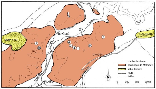
Localisation des phénomènes karstiques dans le poudingue de Malmedy d’après Ozer 1971:
- 1) Trou Ozer
- 2) Doline
- 3) Réseau de la Salle de Visite
- 4) Trou des Nains
- 5) Trou Boever
- 6) Trou Wey
- 7) Résurgences de Bévercé
- 8) Fontaine Marlyre
- 9) Fontaine Simon
- 10) Pertes du ruisseau Simon.
Principale source d’information :

Bei diesen Earthcache, gibt es keine Dose
Dieser Earthcache ist der Nachfolger vom Konglomerat Malmedy und mehr Detailliert.
https://www.geocaching.com/geocache/GC7J8GD_poudingue-de-malmedy-fr-d-nl-en
Um diesen Earthcache besser verstehen zu können, schlage ich vor, euch zuerst mit die Karst Phenomenen im Konglomerat zu beschäftigen.
Am besten tut ihr zuerst Teil 1 besuchen und lösen.
Logbedingungen :
Vor Ort gibt es keine Infotafel, Bitte beantwortet mir aber folgende Fragen :
- Wie sind die Grotten, unterirdische Gänge, usw... entstanden ?
- Welche Zwei Geologische Beisonderheiten hat das Malmedyer Konglomerat ?
Und Hier die Fragen, womit sich heraus stelt das Ihr vor Ort gewesen seit :
- Auf die Koordinaten von Cache, basiert auf die Erklärungen im Listing, welche Farbe hat das Zement vom Konglomerat?
- Bestimme die Mohshärte ( mit eine 10 Eurocent-Münze ) durch an die Felsen zu kratzen. Was könnt ihr beobachten und erkläre wieso ?
- Ein Bild von ihnen ist keine Bedingung, aber immer Willkommen.
Logge diesen Cache als "Found it" und schickt mir die Antworte auf die Fragen, via mein Profiel oder Email (Message Center), falls es Probleme gibt, werde ich mich persönlich bei ihnen melden, Bitte keine Lösungen in den Log oder auf die Bilder.
Vereinfachte Erklärung über das Phänomen “ Karst “ :
Karst ist eine geomorphologische Struktur infolge der Hydro Chemische und hydraulische Erosion von lösliche Gesteine, welche hauptsächlich Kohlensäure-haltige Kalkfelsen sind.
Karst ist zum größten Teil eine gequälte Landschaft und ein unterirdischen Flusssystem, natürlich gegrabene Keller und viele Hohlräume: Ruiniform Relief, Verluste und Anstieg der Wasserläufe, Höhlen und Abgründe.
Wir unterscheiden Drei Sorten Konglomerat in unterschiedliche Schichten
In den Puddingstein von Malmedy unterscheidet man 3 Sorten mit jeweils eigenen Merkmalen. Von unten nach oben, haben wir nacheinander:
- Der 1. (niedrigere) Sitz präsentiert einen Pudding bestehend aus Ton-Zement, vor allem von rote Farbe, der eingesperrte Kiesel ist aus Ardennen Felsen (Sandstein, Quarzit, Quartzophyllade, Schiefer und Arkose), mit einem Durchmesser bis zu 16 cm in Malmedy. Der untere Teil der Bänke besteht aus Schiefer. Die Dicke diese 1. Schicht beträgt in Malmedy ca. 60 m und reduziert sich auf 15 m in Stavelot.
- 2. Sitz (Mittelwert bzw. Median) ist wo die Karst-Phänomene konzentriert sind. Der Pudding besteht aus eine Mischung von Calcaro Ton Zement und eingeschlossene Kopfsteinpflaster aus Kalkstein, Sandstein, Quarzit und Quartzophyllade gemischt mit anderen. Hier in Malmedy ist die Schicht ca. 150 m Dick, in Stavelot beträgt sie nur noch 30 m und nimmt wieder zu bis zu 70 m bei Bass-Bodeux
Diese Schicht hat fossilführenden Kiesel der weitgehend aus den Kalksteinen der mittleren Devon in der Eifel zu Hause sind, die Region vor Prüm, 50 km weiter Östlich. Sehr wahrscheinlich ist dieser Kiezel in die “ Schale von Malmedy “ durch einen Wasserlauf transportiert worden. Mittels ein Unterboden wie eine Halbwüste und einigen Sturzfluten konnten große Blöcke bis 30 cm in Durchmesser transportiert werden! ( Beispiele gibt es in der Nähe von Bévercé)
Das Anteil der oft fossilführenden Kalkstein-Kiesel in den Puddingstein wird weniger je nach Lage vom Nordosten bis zum Südwesten: in Malmedy, repräsentieren sie 60 Prozent der gesamten Menge, 39 % in Bass-Bodeux und nur noch 26 % am Westliche Ende dieser Gegend.
Auch die Größe der Kiesel, alle Arten kombiniert, kennt ein Rückgang gleicher Art wie die der Anteile: von eine Größe von 30 cm Durchmesser, bis weniger als 10 cm in Bas-Bodeux. In diesem letzten Bereich, wo der Pudding aus weniger und kleinere Pebbles besteht konnte dieses Gestein als Baumaterial, verwendet werden. Die Gebäuden der Schule im Dorf aus dem 19. Jahrhundert, sind ein gutes Beispiel dafür.
- Der 3. (obere) Sitz präsentiert einen Pudding aus Ton-Zement und enthält nur schlechte stumpfe Steine der lokalen Felsarten ( Quarzit, Sandstein). Sie ist sowohl in Malmedy und in Stavelot, 30 m dick.
Um zu verstehen, wie diese 3 Sitze innerhalb vom Band der Perm Pudding stehen, muss man klarstellen, dass diese 'Lagerung' nicht horizontal verlauft, sondern abtaucht in Richtung Nordwesten.
Deshalb, wenn man den Pudding hier im Längstschnitt betrachten würde, wo die 3 Sitzen vorhanden sind (zum Beispiel in Bévercé), vom Sudost bis Nordwest, überqueren wir zunächst einen Pudding von der 1. Sitzfläche, dann den Pudding teilweise Kalkstein der 2.Gattung und zu guter Letzt, einer der die 3. Sorte.
Beisonderheiten im Karst von Stavelot-massiv
https://s3.amazonaws.com/gs-geo-images/54084218-02df-4175-bea6-323c46b40106_l.jpg
Das Vorhandensein von Kalkstein in den Pudding von Malmedy ist eine Rarität, im Stavelot-massiv, im Vergleich zu anderen konstituierenden Felsen liegen Hier die Schichten alle frei.
Es ist in den Aufschlüssen der 2. Sitz wo wir die Karsterscheinungen vorfinden. In diese Schicht werden die dicksten und reichsten Kalkstein-Vorkommen gefunden.
Die Gewässern, vom Kambrium, ein Landstrich oberhalb und frei von Kalkstein, fließen in den kalkhaltigen Pudding (das Wasser ist relativ sauer und aggressiv). Der Kontakt von
dieses sauere Wasser mit den Karbonat Felsen, wird durch viele vertikalen Ritzen und Bruche gesammelt und begünstigen somit, die Bildung von Karst.
Im Vergleich mit den üblichen Karst
Im Gegensatz zu den traditionellen 'aktive' Karst-Standorten wächst der Karst im Pudding von Malmedy langsamer und weniger 'spektakuläre' .
Die geologische Zusammensetzung des Konglomerats wird bestimmt von die Löslichkeit der unterschiedlichen Komponenten: die Kalkstein-Kieselsteine reagieren am empfindlichsten auf Korrosion, gefolgt von den Zement des Pudding und die Füllung der Bänke. Diese beiden letzteren, teilweise bestehend aus Kalkstein, können nie ganz abgebaut werden.
Zu guter Letzt sind keine Kalkstein Kieselsteine immun gegen chemische Zersetzung von Wasser. Sobald durch mechanische Erosion von den Wänden gelöst, werden diese sich an der Basis der Brunnen und Galerien sammeln, weil die Kraft des Wassers nicht ausreicht, um sie nach draußen zu evakuieren.
Hohlräume bilden sich durch die Erweiterung von Fügen über mechanische Erosion und Auflösung. Der in den Pudding aufgelöste Kalkstein geht zu einen anderen Ort und ferfestigd sich manchmal wieder, so haben einige Hohlräume Schlammlawinen, Fistel, Stalaktiten oder Stalagmiten.
Diese Konkretionen sind in rot-, braune Tönen, infolge der Anwesenheit von Eisen-Oxide. Deshalb waren die 1. Entdecker vom Loch Ozer total überrascht, ein sauberes weißes Zimmer ( was den Name : Blanc-Moussi bekamm ) mit solche Konkretionen vor zu finden !
Außergewöhnliche Bilder des Lochs Özer und der Brunnen von Rivive sehen sie Hier :
http://www.continent7.be/galerie/anar09/album/index.html
Lage der Karsterscheinungen in Malmedy:
Lokalisierung von karst Phänomenen im Malmedy Puddingstone nach Ozer 1971:
1) Grotte von Ozer
2) Doline
3) Netzwerk aus Zimmern
4) Zwergen Grotte
5) Grotte von Boever
6) Wey Höle
7) Resurgences of Bévercé
8) Brunnen von Marlyre
9) Brunnen von Simon
10) der Verlusst von Simon.
Informationsquellen :
Bij deze Earthcache is er geen doos.
Deze Earthcache is het vervolg op de meer algemene Poudingue de Malmedy. https://www.geocaching.com/geocache/GC7J8GD_poudingue-de-malmedy-fr-d-nl-en
Om deze Eartcache beter te begrijpen, stel ik voor om zich eerst in de karst – fenomenen van het puddinggesteen te verdiepen.
Het is het belangrijk de uitleg van deel 1 goed te begrijpen, alvorens deze te doen.
Logvoorwaarde :
Ter plaatse is er geen infobord, maar gelieve volgende vragen te willen beantwoorden :
- Hoe ontstaan deze grotten, ondergrondse netwerken, enz..... ?
- Welke zijn de twee geologische bijzonderheden van de Malmedyer puddingsteen ?
En hier de vragen die bewijzen dat Uzelf ter plaatse bent geweest, op de koördinaten van de cache, aan hand van de uitleg in de listing:
- Welke kleur heeft het cement van deze puddingsteen?
- Op de schaal van Mohs, test ter plaatse met krabben ( 10 Eurocent ), waar ligt de hardheid, wat kun je zien gebeuren en hoe verklaar je dit ?
- Een foto is facultatief, maar steeds welkom.
Log deze cache als "Found it" en stuur mij de antwoorden op de vragen door, via mijn profiel of via mail (Message Center), bij problemen neem ikzelf contact op. Plaats geen antwoorden in de log of op foto.
Definitie van het verschijnsel Karst :
Karst is een geomorfologische structuur waarbij het gesteente gedeeltelijk oplost door hydro chemische en hydraulische invloed, vooral koolzuurhoudend gesteente, welke in wezen kalkhoudende rotsen zijn.
Karsts zijn voor het grootste deel gekwelde landschappen, meestal gepaard met een ondergronds riviersysteem, uitgeholde kelders en vele holten: ruiniform relief, verliezen en résurgences, water stromen, grotten en afgronden.
Dit puddinggesteen heeft drie verschillende soorten
Binnen de pudding van Malmedy onderscheidt men 3 banken, elk met hun eigen kenmerken. Uit de bottom-up, hebben we achtereenvolgens:
- De 1ste (onderste) bank puddingsteen bestaat uit klei-cement, voornamelijk van rode kleur, de ingesloten steentjes zijn afkomstig van Ardense rotsen (zandsteen, kwartsiet, quartzophyllade, leisteen ), met in Malmedy een diameter tot 16 cm . Het onderste deel van deze bank is van leisteen. De dikte van deze 1e laag bedraagd in Malmedy ongeveer 60 m en vermindert tot 15 m in Stavelot.
- De 2de (middelste- of mediane-) bank bestaat voornamelijk uit geconcentreede karst met de typische verschijnselen. De Pudding is samengesteld uit een calcaro-klei-cement, opgevuld met kasseien van kalksteen en gemengd met zandsteen, kwartsiet en quartzophyllade. De dikte van deze laag bedraagt ongeveer 150 m in Malmedy en nog slechts 30 m in Stavelot, daarna neemt deze terug toe tot 70 m te Bas-Bodeux.
De kalksteen (vaak fossiliferous) en de kiezelstenen stammen grotendeels uit de periode van het Midden-Devoon en zijn uit de Eifel afkomstig, vooral in de regio rond Prüm, 50 km meer naar het Oosten. Waarschijnlijk zijn grote stenen naar de “ Kom van Malmedy “ gebracht middels een waterloop, voorwaarde hiervoor zijn een semi-woestijne ondergrond en overstromingen. Blokken van enorme omvang werden zo aangespoeld.( sommige bereiken een diameter van 30 cm , zoals te vinden in Bevercé) !
Het aandeel van kalkhoudende kiezels daalt naarmate van het noordoosten tot het zuidwesten in Malmedy, zij vertegenwoordigen 60% in het totaal, tegenover 39 procent in bas-Bodeux, aan het westelijke uiteinde van dit gebied slechts nog 26%
Naarmate de kracht van de stroming afneemt, daalt ook de grote van de meegevoerde stenen, van 30 cm tot slechts nog 10 cm in Bas-Bodeux.
Weliswaar is de laag puddinggesteen dunner en de grote van kiezels sterk afgenomen, zo was dit gesteen echter uiterst geschikt als bouwmateriaal. Voorbeelden hiervan vinden we in de oude uit de 19e eeuw stammende schoolgebouwen van het dorp.
- De 3de (bovenste) bank presenteert een pudding uit klei-cement, met enkele slecht afgeronde stenen van lokale rotsen ( kwartsiet, zandsteen). Deze laag is in Malmedy en Stavelot 30 m dik.
Om te begrijpen hoe deze 3 lagen puddinggesteen binnen de band van Perm tot stand gekomen zijn, moet men verduidelijken dat deze niet horizontal uitgelijnd zijn, maar schuin naar het noordwesten afhellen.
Dat is de reden waarom, als men een doorsnede van de pudding-strips zou maken, daar waar de 3 soorten aanwezig zijn ( bijvoorbeeld : regio Bevercé ) en ze van Zuidoost naar het noordwesten verlopen, we eerst de puddingbank van de 1ste soort kruisen, dan de puddinglaag met deels kalksteen van de 2de soort en ten slotte een laag van de 3de vinden.
Enkele bijzonderheden van het karstmassief van Stavelot :
https://s3.amazonaws.com/gs-geo-images/54084218-02df-4175-bea6-323c46b40106_l.jpg
De aanwezigheid van kalksteen in de pudding van Malmedy is een uniek fenomeen in het massief van Stavelot, terwijl andere rotsen met deze samenstellingen verborgen blijven komen deze hier aan de oppervlakte.
Het is in de ontsluitingen van de 2de bank waarin zich de karst-verschijnselen voordoen. Het is dat deze laag het dikste is en het rijkst aan kalksteen, waarom karst verschijnselen worden gevonden.
Vanuit het Cambrium, dus de kalksteen-arme gebieden, komt regenwater (relatief zuur en agressieve) en stroomd naar de kalkhoudende pudding. Het contact van kalkhoudende rots met het zure afvoerwater wordt hier begunstigd door grote barsten in de pudding, in de vorm van vele vertikale scheuren.
Vergelijk met een 'klassieke' karst :
In tegenstelling tot de traditionele 'actieve Karst ' groeid de Karst-site in de pudding van Malmedy langzamer en op een minder 'spectaculaire' manier.
De geologische samenstelling van het conglomeraat zijn bepalend voor de oplosbaarheid van deze verschillende componenten: de kalksteen keien zijn het meest gevoelig voor corrosie, gevolgd door het cement van de pudding en kleine 'infill' bankjes. Deze twee laatste, gedeeltelijk samengesteld uit kalksteen, zullen slechts deels worden aangetast.
Tot slot, niet-kalkhoudende steentjes zijn ongevoelig voor chemische aantasting door water. Eenmaal door mechanische erosie gelost van de muren, zullen ze bij gebrek aan voldoende waterstroom zich ophopen aan de voet van de putten en galerijen en dus niet naar buiten worden geevacueerd.
De exploratie van holten in de pudding vereist het gebruik van speleokoorden, omdat de ondergrondse netwerken overwegend verticale zijn (grot van Ozer = 70 m diep, waarschijnlijk gerelateerd aan het waterpeil van de Warche).
Deze holtes worden gevormd door de verbreding van diaclases ( barsten ) via mechanische erosie en ontbinding. De opgeloste kalksteen in de pudding gaat zich op andere plaatsen terug verstevigen. Sommige van de grotten zijn modderstromen of hebben fistels, stalactieten en stalagmieten.
Deze druipstenen zijn in bruine- rode tinten, die voortvloeien uit de aanwezigheid van ijzeroxiden. Dit is waarom de 1ste speleologen in de grot van Ozer verbaasd waren met de ontdekking van dit concretionnement in een schone witte kamer van de grot (oorspronkelijk uit de naam van de kamer) : de Blanc-Moussî !
Uitzonderlijke foto's van de grot van Ozer en de fontein van Rivive vindt U hier:
http://www.continent7.be/galerie/anar09/album/index.html
Locatie's van karst verschijnselen in Malmedy :
Locaties van de Karts verschijnselen in de Malmedyer Puddingstone volgens Ozer 1971 :
1) grot van Ozer
2) Doline
3) Netwerk van kamers
4) Dwergen grot
5) grot van Boever
6) Wey Hole
7) Resurgences of Bévercé
8) Fontijn van Marlyre
9) Fontijn van Simon
10) het verlies van Simon.
Bronnen van informatie:

There’s no box to this cache.
This Earthcache is the continuation of the general description of Poudingue de Malmedy. https://www.geocaching.com/geocache/GC7J8GD_poudingue-de-malmedy-fr-d-nl-en
For this cache, I propose to deepen the explanations of the karst phenomena of Poudingue.
But before that I advise you to understand the explanations of the 1 ° Earthcache.
Requirements for logging :
There is no explanation on the site, but please answer the following questions:
- How are caves, underground networks, etc. created ?
- What are the two geological peculiarities of Poudingue de Malmedy ?
And here is the question that will prove to me that you went there, In the Earthcache coordinates, with the explanations of the description, could you tell me:
- What is the dominant color of the pudding cement ?
- Try to found out the Mohs-hardness, ( be using a peace of 10 Eurocent ) and scratch at the surface of the rock. What further observations can you make, explain?
- A photo of you, on side of the cache, is always a pleasure, but optional.
Log in this cache "Found it" and send me your answer either via my profile or via messaging at geocaching.com (Message Center), and I will contact you in case of problems. Do not write answers in your log.
Simplified definition of a karst phenomenon:
Karst is a geomorphological structure resulting from the hydro-chemical and hydraulic erosion of all soluble rocks, mainly of carbonate rocks, mainly limestone.
The karsts present for the most part a tormented landscape, an essentially underground hydrographic network (underground rivers) and a basement dug numerous cavities: ruiniform reliefs, losses and resurgences of streams, caves and chasms.
Three different types of foundation in this pudding
In the Poudingue of Malmedy, there are 3 seats with each their own characteristics. From bottom to top, we have successively:
- The 1st (lower) foundation has a clay cement pudding, mostly red in color, trapping pebbles of Ardennes rocks (sandstone, quartzite, quartzophyllade, schist and arkose), with a diameter of up to 16cm at Malmedy. The lower part which presents schist banks. The power (thickness) of this first seat reaches about 60 m at Malmedy, and is reduced to 15m at Stavelot.
- The 2nd seat (medium or median) is where the karst phenomena are concentrated. The poudingue is composed of a calcareous-clay cement, trapping limestone pebbles, mixed with others in sandstone, quartzite and quartzophyllade. Thick from about 150m to Malmedy, to Stavelot it is 30m, before rising then to 70m in Basse-Bodeux.
The calcareous pebbles, often fossiliferous, are mostly derived from Middle Devonian limestones of the Eifel, in the Prüm region, about fifty km further to the east, and most probably brought into this basin of Malmedy by a course of water, in semi-desert conditions with flash floods capable of transporting large blocks (up to 30cm in diameter at Bevercé)!
The proportion of calcareous pebbles within the pudding decreases from north-east to south-west: in Malmedy, they represent 60% of the total, as against 39% in Basse-Bodeux, and only 26% at the western end of this zone.
The decrease in the size of pebbles, all types combined, follows the same distribution: from 30cm to Bévercé, they are less than 10cm in Basse-Bodeux. In this last zone, where the pudding consists of fewer and smaller pebbles, with more interbedded psammite beds, this rock could be used as a building material, as can be seen on the old buildings of the village.
- The 3rd seat (upper) has a clay cement pudding, containing only badly blunt pebbles from local rocks (phyllite, quartzite, sandstone). It is present in Malmedy for 30m thick and in Stavelot.
To fully understand how these 3 seats appear in the Permian poudingue band, it should be noted that this "stack" is not horizontal, but mainly presents a dip to the northwest.
That is why, if we cross the pudding strip where the 3 seats are present (region of Bévercé for example), from the south-east to the north-west, we will first cross a poudingue zone of the 1st seat, then the pudding partly calcareous of the 2nd course and finally that of the 3rd course.
Extension of the karst in the Stavelot massif
https://s3.amazonaws.com/gs-geo-images/54084218-02df-4175-bea6-323c46b40106_l.jpg
The presence of limestone in the Poudingue of Malmedy is a unique feature in the massif of Stavelot, whose other constituent rocks are all lacking.
It is in the outcrops of the 2nd course that the karst phenomena are concentrated. This is where this seat is the thickest and richest in limestone that we find the most karst phenomena.
Runoff from Cambrian limestone-free soils (therefore relatively acidic and aggressive) flows into the calcareous pudding.
The contact of runoff-carbonate water is here favored by the significant fracturing of the pudding, in the form of many vertical breaks.
Comparison with a "classic karst"
Unlike traditional "active" karsts, karstic sites seem to develop more slowly and in a less "spectacular" way in the Malmedy Poudingue.
The geological composition of this conglomerate will determine the solubility of these different components: the calcareous pebbles are the most sensitive to corrosion, followed by the pudding cement and the interspersed benches of psammite. These last two, partially composed of limestone, will only be partially degraded.
Finally, non-calcareous pebbles are insensitive to chemical degradation by water. Once detached from the walls by mechanical erosion, they will accumulate at the base of the wells and galleries, in the absence of sufficient water flow to evacuate to the outside.
The exploration of the pudding cavities requires the use of ropes because the underground networks are mostly vertical (the Ozer hole reaching 70m deep, probably related to the cashing of the Warche).
These cavities were formed by widening of diaclases via dissolution and mechanical erosion. The limestone dissolved in the pudding will in some places form a concretion. Some cavities have castings, fistulas, stalactites, floors, stalagmites.
These concretions are in brown tones, to red, resulting from the presence of iron oxides. That's why the first explorers of Trou Ozer were surprised to discover
See the exceptional photos of the Ozer Hole and the Rivive Fountain: http://www.continent7.be/galerie/anar09/album/index.html
Location of karst phenomena in Malmedy:
Localization of karst phenomena in the Malmedy Puddingstone after Ozer 1971:
1) Ozer hole
2) Doline
3) Network of the Visiting Room
4) Dwarf Hole
5) Boever hole
6) Wey Hole
7) Resurgences of Bévercé
8) Marlyre Fountain
9) Simon Fountain
10) Simon Creek losses.
Main sources of information: