
GROTTE DI BORGIO VEREZZI
Le grotte Valdemino o, più semplicemente, di Borgio Verezzi, sono un sito speleologico di notevole valenza turistica tra i più belli del Ponente Ligure.
Le grotte furono scoperte soltanto nel 1933, ma la presenza di cavità carsiche di una certa rilevanza era nota da lungo tempo: le acque del Rio Battorezza, ad esempio, sembravano essere inghiottite in diversi tratti del suo corso per poi uscire periodicamente, nei periodi di pioggia, ad alluvionare i campi circostanti.
Vi era inoltre un laghetto sul fondo della grotta accessbile dal pavimento della chiesa di San Pietro e, infine, il torrente Roggetto, che sgorga da una frattura ai piedi dell’abitato di Borgio.
Verso la fine degli anni Venti il Podestà Giacomo Staricco (bisononno di un amico d'infanzia dell'owner) decise il Rio Battorezza aveva già troppi danni, ordinando di scavare lungo l'aveo del fiume per cercare di trovare uno sfogo alternativo alle acque. Purtroppo i soldi finirono presto, e ci si dovette quindi accontentare solo di un pozzo profondo qualche decina di metri. L'ennesima alluvione sfondò infine, verso i primi anni Trenta, il sottile diaframma sul fondo del pozzo e consentì alle acqua di scomparire sottoterra.
Nel 1933 tre ragazzini di Borgio, Lillo, Tito e Valentino, entrarono in una nuova grotta, scoperta per caso, e lì scrissero i loro nomi con una candela; la loro scoperta rimase dimenticata fino al 1951, anno in cui Giovanni Dentella, alla guida del Gruppo Speleologico Ingauno, inizio l’esplorazione della grotta trovando un grande complesso di sale e gallerie lungo alcuni chilometri al di sotto dell’abitato di Borgio.
Lo stesso Dentella ideò e realizzò il primo il percorso turistico inaugurato nel 1970.
Di grande importanza sono anche i reperti ossei trovati in diverse parti della cavità.
Si tratta di testimonianze fossili databili tra i 500.000 ed i 750.000 anni fa, comprendono resti di animali estinti quali rinoceronte, elefante, tigre, coccodrillo, macaco, tartaruga e orso, mammut, cervo, stambecco, cavallo, testimoniando l'alternanza tra periodi glaciali e periodi caldi che ha caratterizzato gli ultimi due milioni di anni.
La temperatura all'interno delle grotte è di 16°C, con un tasso di umidità relativa dell'aria intorno al 95%-98%.
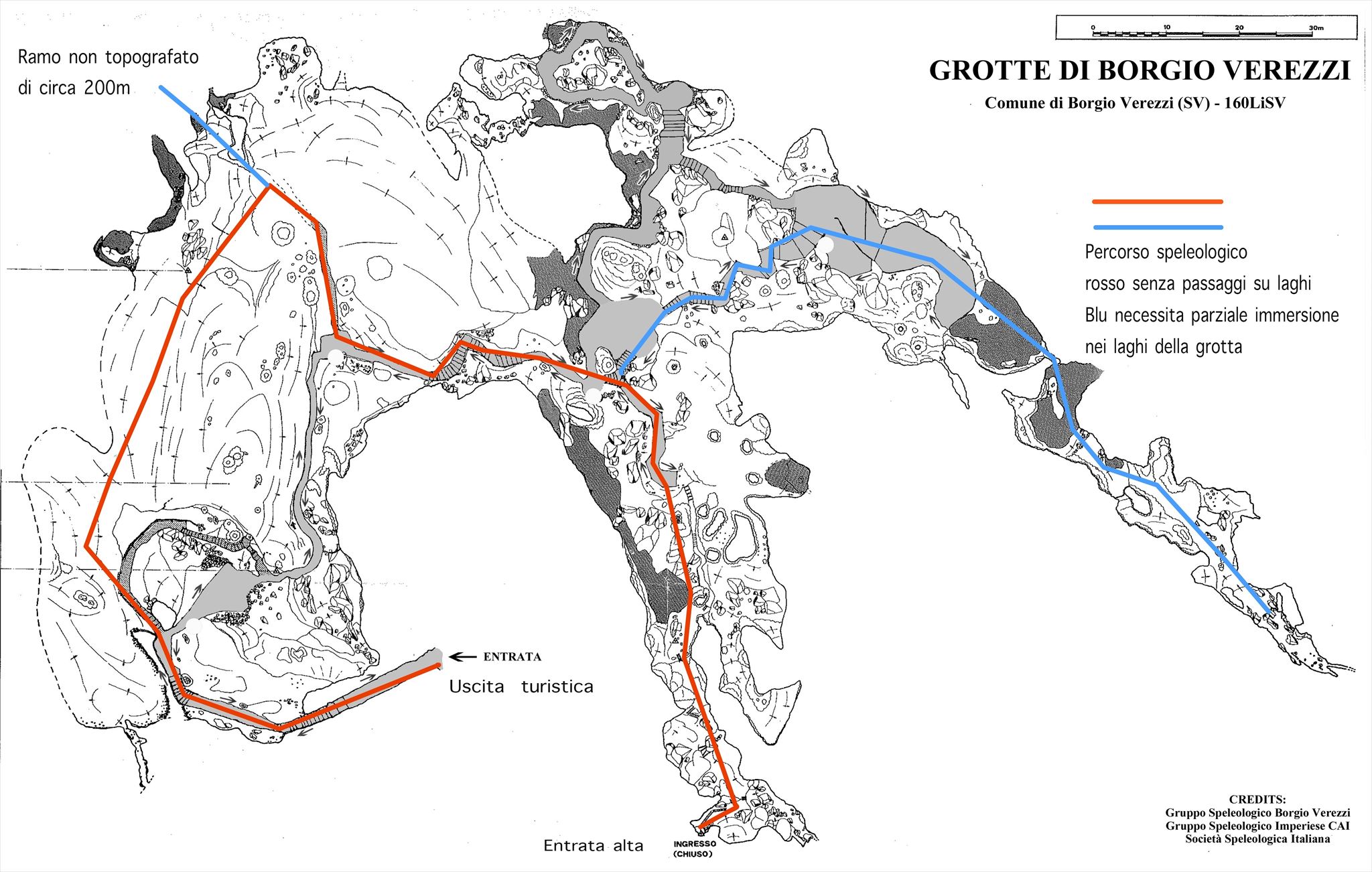
La galleria d'accesso, a 36 metri sopra il livello del mare, conduce nella prima sala e, progressivamente per circa 800 metri, attraverso la Sala del Castello, uno dei punti più bassi del percorso situato a 10 metri sopra il livello del mare e poi ancora fino alla fine del percorso.
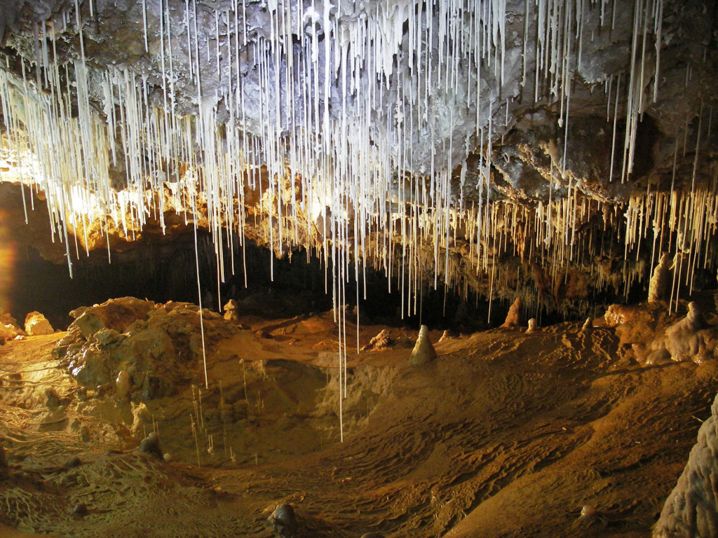
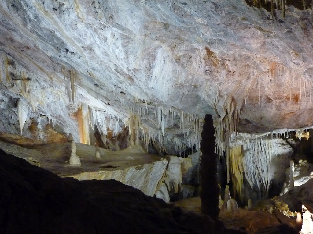
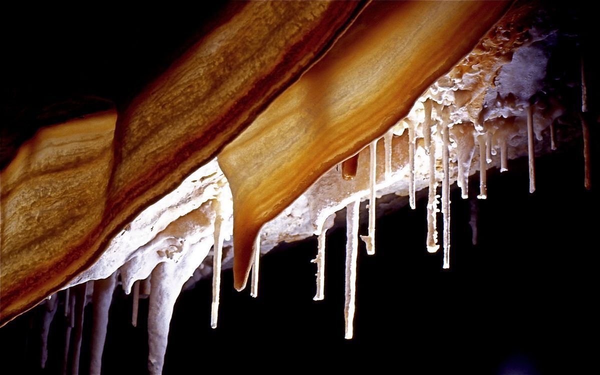
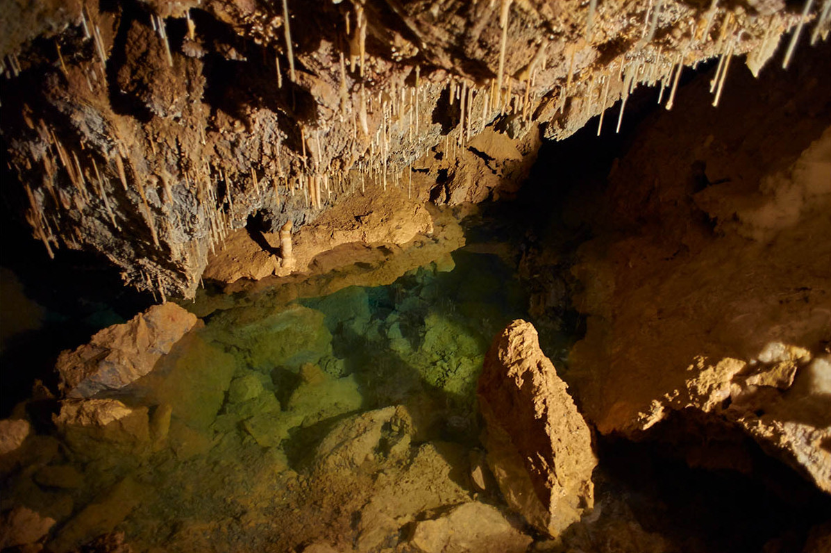
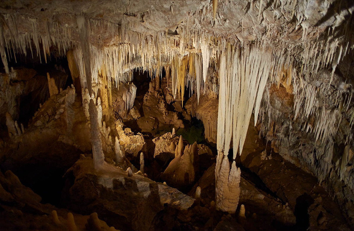
Una notevole peculiarità che contraddistingue le grotte è la ricca varietà di colori delle formazioni minerali, dal bianco puro del carbonato di calcio al rosso-brunito degli idrossidi di ferro, dal giallo della limonite al grigio del manganese.
Vi sono inoltre svariate concrezioni calcaree, dalle più sottile alle più grandi.
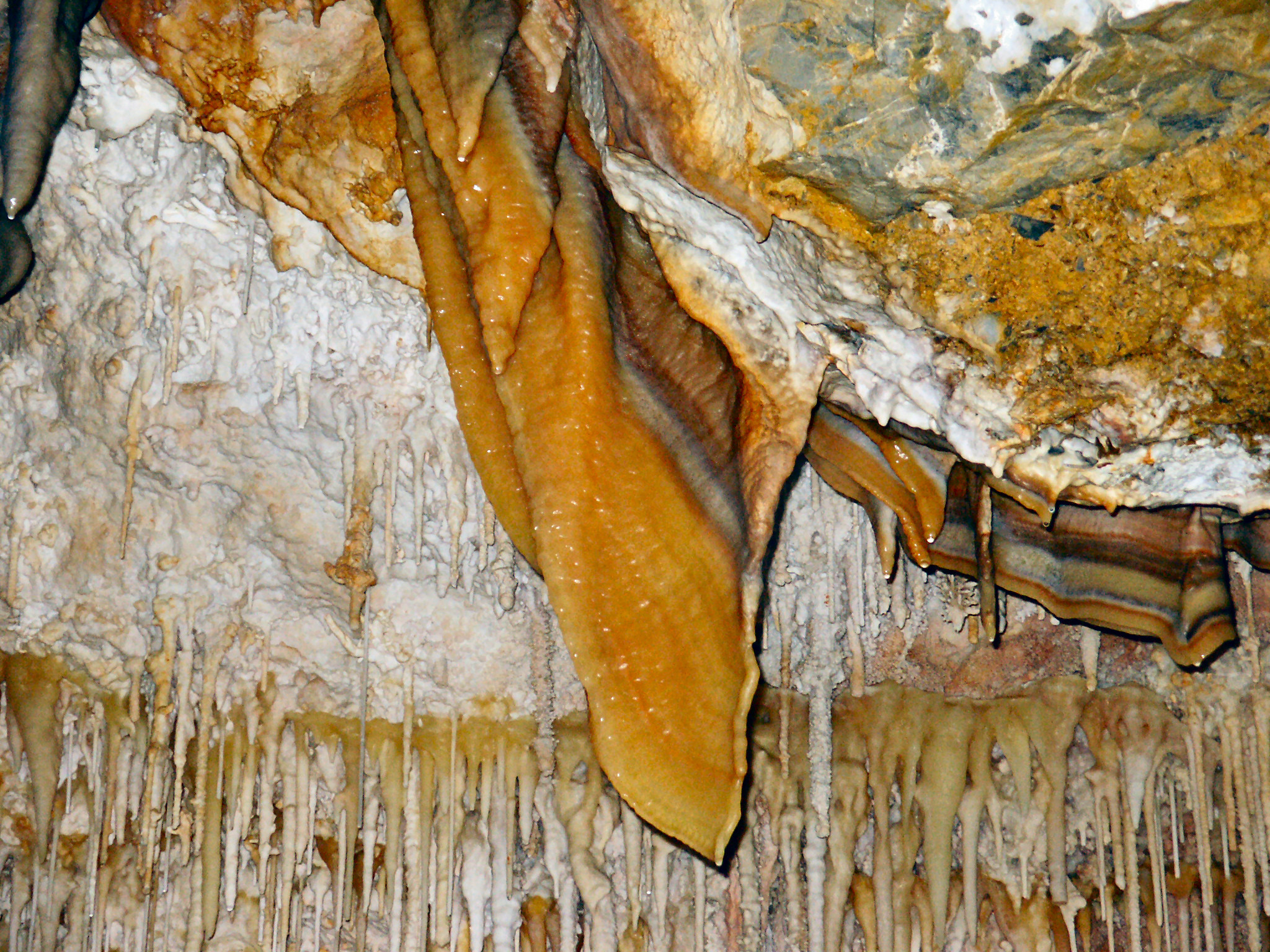
Vi sono le cannule, esili stalattiti filiformi, chiamate anche “spaghetti”, consistenti in sottili tubicini di calcare, vi sono concrezioni in fase giovanile, formazioni cioè che possono anche crescere ed evolversi, col tempo, in stalattiti più spesse e massicce, fino alle più grandi formazioni minerali, sono spesso millenarie, come le colate e le colonne.
Si possono inoltre trovare i drappeggi, o stalattiti lamellari, che paiono delle stoffe (quali il Manto di S. Martino e l'Orecchio dell'Elefante), la cui forma è dovuta allo scivolamento dell'acqua lungo pareti di roccia inclinata e alla ventilazione.

GEOLOGIA
Le grotte si sono formate grazie al fenomeno carsico nella roccia calcareo-dolomitica chiamata Dolomia di San Pietro ai Monti (composta di carbonato di calcio e carbonato di magnesio).
Le vicende geologiche di quest'area iniziano a differenziarsi da quelle dei domini circostanti nel Trias superiore. Alla fine del Carbonifero superiore, 280 milioni di anni fa, vi era in queste zone una crosta continentale formata prevalentemente da rocce vulcaniche di tipo granitico, che sottoposte a forti erosioni produssero materiali incoerenti come ciottoli e sabbie, trasportati e successivamente depositati in ambienti continentali e marini. Tali prodotti, dopo trasformazioni chimiche e meccaniche, originarono quindi formazioni permo-carbonifere, tra cui gli Scisti di Gorra.
Quasi contemporaneamente a questi cicli erosivi si affiancarono fenomeni vulcanici rappresentati da colate e tufi dovuti alla fusione di materiali presenti sotto la crosta.
Verso la fine del Permiano vi furono le ultime fasi dell'orogenesi Ercinica con la produzione di nuovo materiale di erosione e deposizione in ambiente continentale e nel delta di grandi fiumi. In particolare vi sono indicazioni di avanzamento del mare con i depositi di tipo sabbioso con le quarziti (Quarziti di Ponte Nava) e con la deposizione in ambiente marino poco profondo di fanghi calcarei sottoposti in seguito a fenomeni di dolomitizzazione. Di questi periodi sono le formazioni calcaree e dolomitiche dei Calcari di Val Tanarello e delle Dolomie di San Pietro dei Monti.
La sedimentazione marina riprende poi nuovamente nel Cretaceo superiore con i depositi della Formazione di Caprauna. Nel Paleocene ulteriori depositi calcarei con detriti e sabbie miste testimoniano un periodo di instabilità, mentre il Miocene è caratterizzato dalle formazioni della Pietra di Finale, testimoniante un'attività vulcanica diffusa. Questa formazione è costituita da calcari originati dall'accumulo di gusci di lamellibranchi e organismi a guscio calcareo, testimoniante la presenza del mare e di un clima tropicale.
Con l'inizio del Quaternario si alternano periodi di grandi glaciazioni, con modesti accumuli solo alle quote più elevate delle Alpi Marittime, e con fenomeni di innalzamento e abbassamento del livello marino che generano dei terrazzamenti marini con depositi di sabbie e ciottoli.
La degradazione operata dall’acqua sui calcari dà origine alle “Terre rosse”, ricche di ossidi di ferro, e sempre durante il Quaternario le formazioni calcaree, ora completamente emerse, vengono soggette a fenomeni di erosione carsica dando origine alle molte grotte presenti nell'area.
SISTEMA CARSICO BORGESE
La caratteristica principale delle rocce descritte sopra è la presenza di molte microfratture, di campi solcati e di doline.
Tutti questi fenomeni di superficie fanno si che le acque piovane possano penetrare all’interno e, prima con un'azione corrosiva e poi erosiva, possano creare un intricato reticolo di piccole condotte sotterranee che andranno ad alimentare nel corso dei millenni un corso d’acqua collettore che a sua volta creerà una sorgente in zone più a valle.
Nel caso del sistema carsico Borgese le sorgenti sono sotto il livello del mare; si nota infatti che esiste, a pochi metri da riva, una sorta di barriera formatasi da depositi calcarei tipici delle sorgenti carsiche.
Una traccia del collettore nelle grotte di Borgio è evidente in caso di mancanza di precipitazioni, oltre il tratto turistico delimitato del laghetto nella Sala del Presepe.
A causa di forze idrostatiche e di bradisismo centinaia di migliaia di anni fa gli strati geologici si separarono di netto, cambiando la morfologia delle grotte.
Il distacco infatti procurò la formazione di vaste sale e di conseguenza le acque piovane che attraverso il reticolo sopracitato arrivarono in grotta iniziarono a formare un particolare ed unico sistema di concrezioni e di laghi interrompendo il formarsi della primigena galleria.
Le acque artefici delle sculture stalattitiche presenti in grotta provengono da punti diversi del sistema carsico: un gruppo di stalattiti potrà essere alimentato da microfratture di superficie distanti anche centinaia di metri dal luogo di formazione.
A prova di questo vi sono le colorazioni delle concrezioni diverse tra loro anche a distanza di pochi centimetri, proprio perché l’apporto idrico di una arriva da una zona diversa rispetto all’altra.
FONTI
Carsismo. Wikipedia, L'enciclopedia libera.
Grotte di Borgio, sito internet ufficiale
Mario Pangrazzi. Piccola storia di Borgio Verezzi. L'alfiere Culturale, 1974
Stefano Mortari, Alberto Chiarelli. Le Grotte di Borgio Verezzi. Comune di B.V., 2006
NOTA IMPORTANTE
Le risposte a questa earthcache possono essere trovate anche senza entrare all'interno delle grotte (a pagamento), leggendo attentamente gli opuscoli gratuiti che il Comune di Borgio Verezzi fornisce presso la Biblioteca Comunale e il sito del Comune.
In ogni caso consiglio vivamente la visita al sito carsico per via della sua bellezza, e riporto quindi qui di seguito i dettagli.
Ingressi alle ore: 9:30 - 10:30 - 11:30 - 15:00 - 16:00 - 17:00
Chiuso il lunedì (eccetto i festivi), il 25 dicembre e il 1° gennaio.
Tariffe (guida inclusa): Adulti € 9,00, Bambini 4-12 anni € 6,00 (fare comunque riferimento al sito ufficiale).
EARTHCACHE
Per poter registrare come "found" questa eartcache devi rispondere alle seguenti tre domande.
Stage 1 - Verso le grotte
La strada dallo stage 1 all'ingresso delle grotte è dipinta, e vi sono alcune sagome stilizzate di un animale disegnate per terra.
Qual è l'animale disegnato?
Stage 2 - Nelle grotte
Nell'ultima sala delle grotte, la cosiddetta "Sala di Gulliver", vi è una concrezione dalla forma particolare.
Quale è il nome di questa concrezione?
Stage 3 - Ragionando un po'
Supponiamo che venga a mancare l'apporto di acque calcaree alle concrezioni delle grotte per un cambiamento all'esterno.
Cosa pensi succederebbe alle formazioni all'interno delle grotte?
OBBLIGATORIO: fatti una foto o falla al tuo GPS/smartphone/nickname (a scelta) nel luogo della EC (a scelta tra quelli sopra).
Si prega di non scrivere le risposte nel log, ma di inviarle attraverso il mio profilo su geocaching.com.
Puoi fare il log quando hai inviato le risposte, senza aspettare la mia conferma.
Se le tue risposte sono sbagliate ti contatterò.

BORGIO VEREZZI CAVES
The Valdemino caves or, more simply, of Borgio Verezzi, are a speleological site of considerable touristic value among the most beautiful of the West Ligurian.
The caves were discovered only in 1933, but the presence of karst cavities of a certain importance was known for a long time: the waters of the Rio Battorezza, for example, seemed to swallow in different parts of its course and then periodically go out, during periods of heavy rains, flooding the surrounding fields.
There was also a pond on the bottom of the cave accessible from the floor of the church of San Pietro and, finally, the stream Roggetto, which flows from a fracture at the foot of the town of Borgio.
At the end of the Twenties the Podestà Giacomo Staricco (grand-grand-father of a childhood friend of the owner) decided the Rio Battorezza had done too much damage, ordering to dig along the stream of the river to find an alternative to exaust the waters. Unfortunately money ended soon, and was created only a ten meters well. Another flood finally broke through, in the early Thirties, the thin diaphragm on the bottom of the well and allowed the water to disappear underground.
In 1933 three boys from Borgio, Lillo, Tito and Valentino entered a new cave, discovered by chance, and there they wrote their names with a candle; their discovery was forgotten until 1951, the year in which Giovanni Dentella, at the helm of the Ingauno Speleological Group, began to explore the cave, finding a large complex of rooms and galleries long a few kilometers below the town of Borgio.
Dentella himself conceived and built the first tourist route inaugurated in 1970.
The bones found in different parts of the cavity are also of great importance.
These are fossil records dating from 500,000 to 750,000 years ago, including remains of extinct animals such as rhinoceros, elephant, tiger, crocodile, macaque, turtle and bear, mammoth, deer, ibex, horse, witnessing the alternation between glacial periods and warm periods that have characterized the last two million years.
The temperature inside the caves is 16° C, with a relative humidity of the air around the 95%-98%.
The access tunnel, 36 meters above sea level, leads into the first hall and, progressively for about 800 meters, down to the Sala del Castello, one of the lowest points of the route located 10 meters above sea level and then again till the end of the complete path.
A remarkable peculiarity that distinguishes the caves is the rich variety of colors of the mineral formations, from the pure white of calcium carbonate to the red-browned iron hydroxides, from the yellow of the limonite to the gray of the manganese.
There are also various calcareous concretions, from the thinnest to the largest.
There are the cannulae, thin threadlike stalactites, also called "spaghetti", consisting of thin limestone tubes, there are concretions in the juvenile phase that can still grow and evolve, over time, into thicker and more massive stalactites, and larger mineral formations, often millenarian, like castings and columns.
You can also find the drapes, or lamellar stalactites, which look like fabrics (such as the Mantle of St. Martin and the Ear of the Elephant), whose shape is due to the slipping of water along inclined rock walls and to ventilation.
GEOLOGY
The caves were formed thanks to the karst phenomenon in the calcareous-dolomite rock called Dolomia di San Pietro ai Monti (composed of calcium carbonate and magnesium carbonate).
The geological events of this area begin to differentiate themselves from those of the surrounding domains in the upper Trias. At the end of the upper Carboniferous 280 million years ago, in these areas there was a continental crust formed mainly by granite-like volcanic rocks, which uder strong erosion produced incoherent materials such as pebbles and sand, transported and subsequently deposited in continental and marine environments. These products, after chemical and mechanical transformations, originated therefore permo-carboniferous formations, including the Scisti di Gorra.
At the same time of these erosive cycles there were also volcanic phenomenas, represented by lava castings and tuff due to the fusion of materials present under the crust.
Toward the end of the Permian there were the last phases of the Hercynian orogeny with the production of new material of erosion and deposition in the continental and in the delta of large rivers environments. In particular, there are indications of progress of the sea with deposits of sandy type with quartzites (Quarziti di Ponte Nava) and with the deposition in a shallow marine environment of calcareous muds subjected to dolomitization phenomena. Calcareous and dolomite formations of the Calcari di Val Tanarello and the Dolomites of San Pietro dei Monti belongs to this period.
The marine sedimentation resumed again in the Upper Cretaceous with the deposits of the Caprauna Formation. In the Paleocene further calcareous deposits with debris and mixed sands bear witness to a period of instability, while the Miocene is characterized by the formations of the Finale Stone, testifying a widespread volcanic activity. This formation consists of limestone originating from the accumulation of Lamellibranchiata shells and limestone shell organisms, testifying the presence of the sea and a tropical climate.
With the beginning of the Quaternary periods of great glaciations alternate, with modest accumulations only at the highest altitudes of the Maritime Alps, and with phenomena of rising and lowering of the sea level that generate sea terraces with deposits of sand and pebbles.
The degradation caused by water on limestone gives rise to the "red earths", rich in iron oxides, and during the Quaternary period the calcareous formations, now completely emerged, are subjected to karstic erosion giving birth to the many caves present in the area.
BORGIO KARST SYSTEM
The main characteristic of the rocks described above is the presence of many micro fractures, of furrowed fields and sinkholes.
All these surface phenomena make the rainwater penetrate inside and, first with a corrosive and then erosive action, it can create an intricate network of small underground pipelines that will feed a collector watercourse over the millennia, which will create a fountain in areas further downstream.
In the case of the Borgese karst system the springs are below sea level; you can notice that a sort of barrier is formed by calcareous deposits typical of the karst springs exists just a few meters from the shore.
A trace of the collector in the caves of Borgio is evident in case of lack of rainfall, beyond the delimited tourist stretch of the pond in the Sala del Presepe.
Due to hydrostatic forces and bradyseism, hundreds of thousands of years ago the geological strata separated, changing the morphology of the caves.
The detachment in fact procured the formation of vast salt and consequently the rainwater that through the above-mentioned lattice arrived in the cave began to form a particular and unique system of concretions and lakes interrupting the formation of the first gallery.
Le acque artefici delle sculture stalattitiche presenti in grotta provengono da punti diversi del sistema carsico: un gruppo di stalattiti potrà essere alimentato da microfratture di superficie distanti anche centinaia di metri dal luogo di formazione.
A prova di questo vi sono le colorazioni delle concrezion,i diverse tra loro anche a distanza di pochi centimetri, proprio perché l’apporto idrico di una arriva da una zona diversa rispetto all’altra.
The waters responsible of the creation of the stalactitic sculptures present in the cave come from different points of the karst system: a group of stalactites can be fed by surface microfractures that are also hundreds of meters away from the training site.
As a proof of this there are the colors of the concretions, different from each other even at a distance of a few centimeters, just because the water supply of one arrives from one area different from the other.
IMPORTANT NOTE
The answers to this earthcache can also be found without entering the caves (for a fee), carefully reading the free brochures that Borgio Verezzi Municipality provides at the Municipal Library and the Municipality's site.
Anyway I strongly recommend the visit to the karst site because of its beauty, so I'm giving you some details.
Entrance at: 9:30 - 10:30 - 11:30 - 15:00 - 16:00 - 17:00
Closed on Mondays (except on Christmas and Easter holidays), on Christmas and 1st, January.
Rates (guide included): Adults € 9.00, Children 4-12 years € 6.00 (please refer to the official website).
EARTHCACHE
To register as "found" this eartcache you have to answer to two simple questions.
Stage 1 - Towards the cave
The road from stage 1 to the caves entrance is painted, and there are some stylized silhouettes of an animal drawn on the ground.
Which animal?
Stage 2 - Into the cave
In the last room of the caves, the so-called "Room of Gulliver", there is a particular concretion.
Which is the name of this concretion?
Stage 3 - Thinking a bit '
Let us suppose that the contribution of calcareous waters to the concretions of the caves is missing for a change in the upper environment.
What do you think would happen to the formations inside the caves?
MANDATORY TASK: take or a selfie or a photo of your GPS/smartphone/nickname (choose one) in foreground at EC location (choose one from above).
Please do not write answers in the log, but send them through my profile on geocaching.com
You can do the log when you have posted answers, without waiting for my confirmation.
If your answers are wrong I will contact you.