Battle of Navarino - British Empire
The cache is on the islet of Chelonisi in the middle of the bay of Navarino, it was named so because of its shape that resembles a turtle.
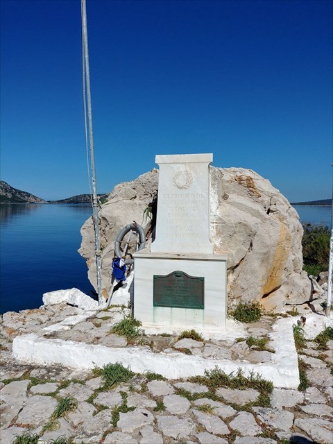
On the island you'll find the monument for the English dead men of the Naval Battle of Navarino.
Short description from Wikipedia:
The Battle of Navarino was a naval battle fought on 20 October 1827, during the Greek War of Independence (1821–32), in Navarino Bay (modern Pylos), on the west coast of the Peloponnese peninsula, in the Ionian Sea. Allied forces from Britain, France, and Russia decisively defeated Ottoman and Egyptian forces trying to suppress the Greek war of independence, thereby making much more likely the independence of Greece.
There is a celebration of this victory on the 20 October every year, sometimes with warships of the winning countries (Russia usually sends one). You can also see two bronze cannons in Pylos Square next to the memorial.
An interesting fact ist that King Otto of Greece (a Bavarian Prince) had the cannons removed from the ground and he sold them to Germany. They were melted and used to create different monuments in Bavaria such as the "Obelisk am Karolinenplatz", "Bavaria" and the "Bronze statue of Count Tilly"
How to get there:
- You can swim to the islet from Gialova (your own risk!), it's about 1.1km from the Camping
- You can rent a boat in Pylos (might be the better idea if you want to visit the other cache on Sfaktiria and see the other Monuments)
There are other monuments around the bay:
- Monument of the Russians (36°56'05.4"N 21°40'01.5"E)
- Monument of the French (36°54'23.8"N 21°40'22.4"E)
- Monument of Santa Roza (36°55'05.4"N 21°40'28.3"E)
- Monument of the Greeks (36°54'46.0"N 21°40'26.5"E)