Earthcache by

Lord Yoruno

ADDA
L'Adda, il cui nome deriva dal celtico "Abdua" e significa "acqua corrente", è il quarto fiume italiano per lunghezza dopo il Po, Adige e Tevere grazie al suo percorso che si sviluppa per 313 km, e il sesto per ampiezza di bacino dopo il Po, Tevere, Adige, Tanaro e Arno. È il più lungo affluente del Po e della penisola.
Attraversa le Province di Sondrio, Como, Lecco, Bergamo, Monza e Brianza, Milano, Cremona e Lodi. È il principale immissario del Lario. Sfocia nel Po in località Brevia nel comune di Castelnuovo Bocca d'Adda, in provincia di Lodi.
Storicamente l'Adda è stato soggetto a piene ed esondazioni su tutto il suo percorso: ha cambiato più volte il suo alveo, sia in Valtellina, sia sul Pian di Spagna sia nel suo basso corso.
Nonostante gli interventi umani, che hanno progressivamente ridotto la possibilità di esondazioni, non sono mancati eventi di piena eccezionali: nel novembre 2002, per esempio, forti piogge ingrossarono pesantemente il fiume, tra l'uscita dal lago di Como e la confluenza con il Brembo, causando così una violenta piena di 2.500 m³/s che sommerse in parte la città di Lodi.
GEOLOGIA
Il corso dell’Adda si snoda, nella sua parte meridionale, tra depositi alluvionali.
I terrazzi fluvio-glaciali più antichi, di età olocenica, sono i più distanti dal letto fluviale, mentre i più recenti degradano lentamente verso l’asta del fiume.
Il ghiacciaio che millenni or sono, nel quaternario, scendeva dalle Alpi verso la pianura, nel suo alterno avanzare e regredire, ha dato origine a formidabili anfiteatri morenici.
Ritiratosi definitivamente il ghiacciaio, il fiume si è lentamente scavato il proprio letto trasportando con sé enormi quantità di detriti morenici. I territori attraversati dal fiume sono perciò costituiti sia da depositi fluvio-glaciali più antichi (argille rosso giallastre, i cosiddetti ferretti) e localmente, tra Paderno e Trezzo, da banchi conglomeratici (ceppo), erosi dal corso del fiume, sia da depositi di epoca più recente, ghiaiosi e sabbiosi, presenti soprattutto tra Cassano e Truccazzanoe poi più a sud.
Il territorio è caratterizzato dal punto di vista lito-stratigrafico da una potente serie di depositi alluvionali pleistocenici-olocenici (periodo Quaternario).
La principale caratteristica che contraddistingue il sottosuolo è l'estrema variabilità che presentano le facies litografiche sia in senso verticale che orizzontale, rispecchiando quindi condizioni ambientali di tipo continentale fluviale-fluvioglaciale.
I litotipi principali sono sabbioso-limosi, ghiaioso-sabbiosi, e, in misura minore, argillosi. In genere sono caratterizzati da una tessitura non costante nonché da una graduale diminuzione della granulometria mano mano che ci si sposta dalla zona Nord verso quella Sud.
Tra i litotipi più frequentemente presenti:
- depositi ghiaiosi, sabbiosi, sabbioso-limosi attuali e recenti.
Costituiscono i depositi alluvionali degli alvei abbandonati ed attivi oltre che i terrazzi morfologici immediatamente sottostanti il livello fondamentale della pianura. Sono localizzati in prossimità e lungo gli alvei dei fiumi.
I litotipi più grossolani sono ubicati lungo il corso settentrionale del fiume Adda;
- depositi alluvionali argillosi d'ambiente palustre.
Sono limitati ad aree piuttosto ristrette lungo il corso del fiume Adda;
- depositi alluvionali fluviali e fluvioglaciali caratterizzati da sabbie-ghiaiose, limisabbiosi, argille-limose ed argille.
Costituiscono i litotipi predominanti lungo l'intero comprensorio e caratterizzano il livello fondamentale della pianura. In particolare i litotipi sabbioso-ghiaioso prevalgono nel settore centro-settentrionale e sono caratterizzati da una discreta omogeneità;
- depositi alluvionali fluvioglaciali caratterizzati da un potente suolo d'alterazione argilloso di colore giallo-ocra.
Rappresentano i litotipi più antichi presenti all’interno della. Compaiono in aree molto limitate nel settore centro-meridionale.
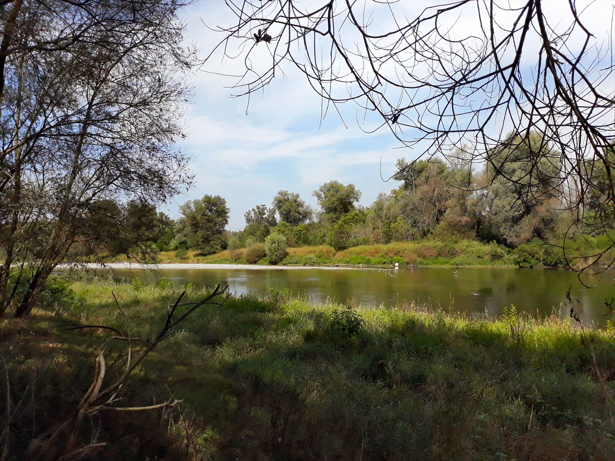
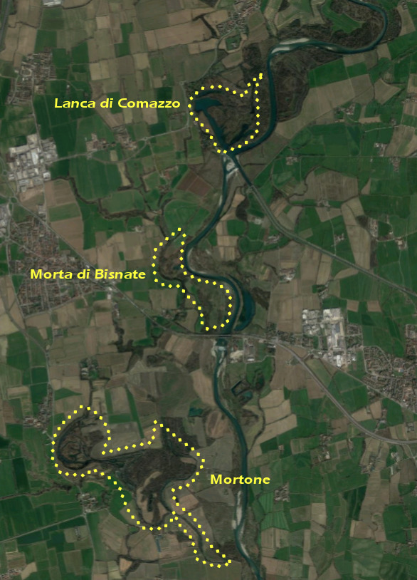
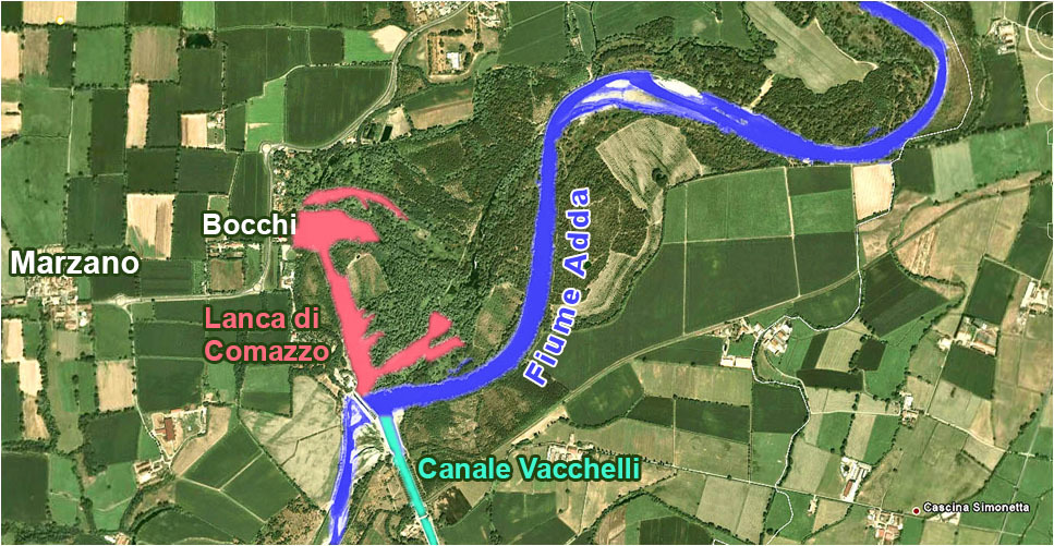
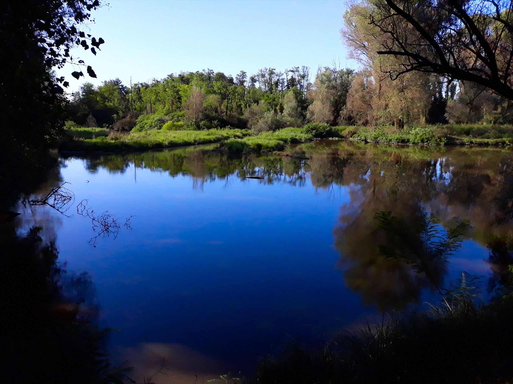
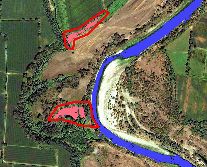
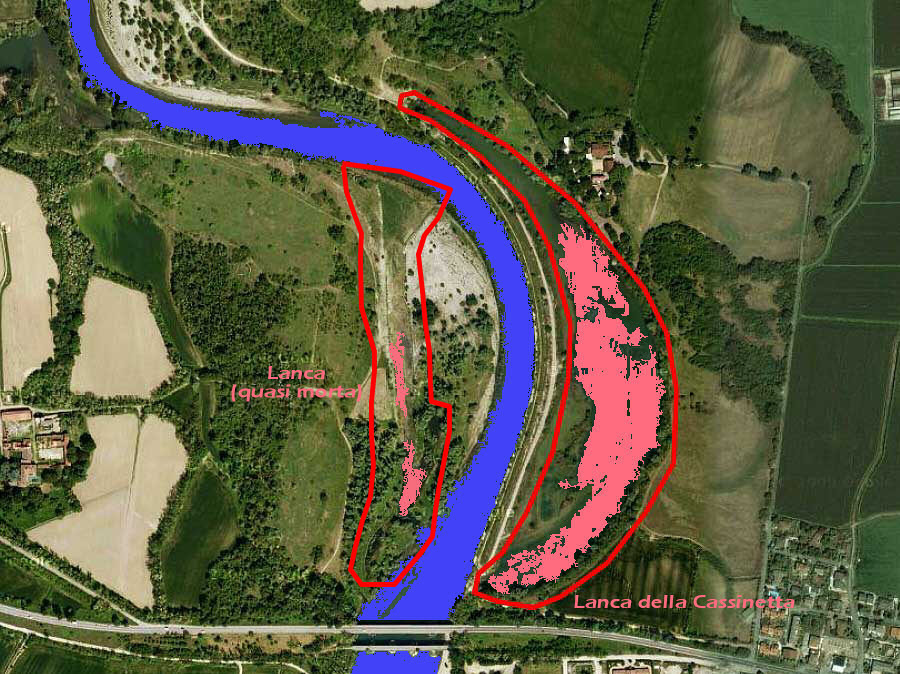
Il territorio comprende, oltre ai boschi rivieraschi, anche zone palustri costituite da lanche e "morte" che il fiume ha formato nel tempo, cambiando percorso; alcuni esempi di grande interesse, per il significato geomorfologico, botanico e zoologico che hanno assunto, sono l’Adda Morta, (un vecchio ramo del fiume, nei comuni di Castiglione d’Adda e Formigara), la Zerbaglia (zona umida di interesse nazionale nei comuni di Turano, Cavenago d’Adda e Credera Rubbiano), la Lanca di Soltarico (formatasi dopo l’alluvione del 1976), la Lanca di Comazzo, la Morta di Bisnate, la Lanca della Cascinetta e il Mortone di Merlino.
LANCHE
In qualsiasi corso d’acqua meandriforme, le lanche (ma in generale tutti gli ambienti umidi laterali) fanno parte integrante del fiume e sono con esso in continua evoluzione.
La formazione della lanca avviene attraverso un meccanismo di divagazione dell’alveo principale: il progressivo avvicinamento dei lobi di due meandri contigui, e la loro successiva fusione, tagliano l’ansa e originano un meandro morto, ossia la lanca.
Quest’ultima può mantenere o meno la connessione con il fiume che l’ha originata, venendo quindi alimentata da acque correnti, da acque di falda o piovane.
Tali ambienti tendono naturalmente a modificarsi e a interrarsi a causa dell’accumulo di sedimenti apportati dalle piene che le raggiungono, o per l’espansione della vegetazione palustre (ad esempio il canneto) e di altre specie vegetali; quest’ultimo processo risulta accelerato in caso di condizioni eutrofiche delle acque di lanca.
MORTE
Nel caso in cui il collegamento di una lanca con il corso principale venga a mancare la lanca diverrà una "morta", un ramo abbandonato senza più alcun collegamento diretto e il cui apporto idrico avviene tramite acque di falda o piovane.
Si tratta quindi, come per tutte le acque ferme, di un elemento effimero la cui naturale evoluzione verso il completo prosciugamento può essere soltanto contrastata e rallentata tramite interventi antropici.
In molti casi infatti si tende a mantenere vive queste zone in quanto ambienti ricchi di fauna e, quindi , di grande interesse naturalistico.
MORTA DI BISNATE
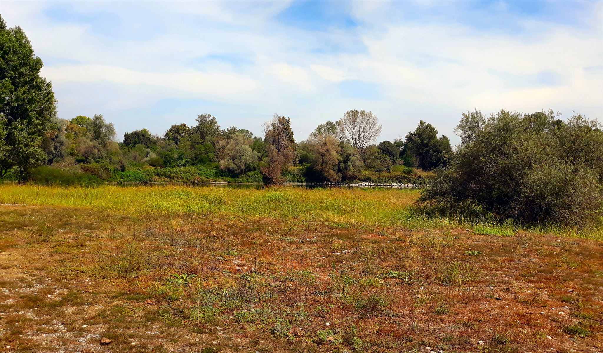
La zona a nord-est di Bisnate è caratterizzata da due ambienti completamente differenti, il primo a nord, tipico delle zone di "morta", e uno a est, con le caratteristiche della tipica "lanca" fluviale ancora alimentata.
Vi è poi una zona intermedia in cui la conformazione del terreno, dovuta alle alluvioni del fiume, ha portato alla formazione di una zona intermedia tra le due; qui non si sono riuscite a creare le condizioni tali da consentire un'alimentazione costante d'acqua, ma neanche una presenza massiva che desse vita ad una zona paludosa colonizzabile dalle piante tipiche quali canneti.
La earthcache
Per poter registrare come "found" questa earthcache devi rispondere alle seguenti domande:
1) Alle coordinate della earthcache ti troverai sulla parte alta dell'argine del fiume, da cui potrai vedere a nord-ovest il Waypoint 01; qui si trova la vera e propria "morta", consistente in una zona paludosa, colonizzata dalla vegetazione tipica della zona.
Più in là, ad est, puoi vedere il fiume Adda al Waypoint 02.
Quale è la differenza di altezza tra la zona paludosa e il fiume ( approssimata)?
2) Recati poi al Waypoint 03; qui la conformazione rispetto al WP 01 è completamente diversa.
Descrivi la tipologia dei depositi ghiaiosi o sassosi circostanti (tipologia, granulometria media)?
3) Sempre relativamente al Waypoint 03, cosa pensi che accadrà al terreno nei prossimi anni? Potrebbe diventare una "morta" o una "lanca"?
4) OBBLIGATORIO: fatti una foto o falla al tuo GPS/smartphone/nickname (a scelta) nel luogo della EC (a scelta tra quelli sopra).
Si prega di non scrivere le risposte nel log, ma di inviarle attraverso il mio profilo su geocaching.com.
Puoi fare il log quando hai inviato le risposte, senza aspettare la mia conferma.
Se le tue risposte sono sbagliate ti contatterò.

ADDA
The Adda (Latin Abdua, or Addua; in Lombard Ada or, again, Adda in local dialects where the double consonants are marked) is a river in North Italy, a tributary of the Po. It rises in the Alps near the border with Switzerland and flows through Lake Como. The Adda joins the Po a few kilometres upstream of Cremona. It is 313 kilometres (194 mi) long. The highest point of the drainage basin is the summit of la Spedla (a subpeak of Piz Bernina), at 4,020 metres (13,190 ft).
Towns along the river Adda include Bormio, Brivio, Tirano, Sondrio, Bellagio and Lecco (both on Lake Como), and Lodi.
Historically, the Adda has been subject to floods along its entire course: it has changed its riverbed several times, in Valtellina, on the Pian di Spagna and in its lower course.
Despite the human interventions, which have gradually reduced the possibility of flooding, there were many exceptional flood events: in November 2002, for example, heavy rains swelled the river heavily, between the exit from Lake Como and the confluence with Brembo, thus causing a violent flood of 2,500 m³/s that partially submerged the city of Lodi.
GEOLOGY
The Adda course winds its way through alluvial deposits in its southern part.
The oldest fluvial-glacial terraces, of the Holocene age, are the most distant from the river bed, while the more recent ones slowly degrade towards the riverbed.
The glacier that millennia ago, in the Quaternary, descended from the Alps towards the plain, in its alternating progress and regress, gave rise to formidable morainic amphitheatres.
Once the glacier was definitively retired, the river slowly dug its own bed carrying huge quantities of moraine debris. The territories crossed by the river are therefore made up of more ancient fluvio-glacial deposits (yellowish red clays, the so-called ferretti) and locally, between Paderno and Trezzo, from conglomerate banks, eroded by the river, both from more recent deposits, gravelly and sandy, mainly present between Cassano and Truccazzano and then further south.
The territory is characterized from the litho-stratigraphic point of view by a powerful series of Pleistocene-Holocene alluvial deposits (Quaternary period).
The main characteristic that distinguishes the subsoil is the extreme variability that present the lithographic facies both vertically and horizontally, thus reflecting environmental conditions of fluvial-fluvial continental type.
The main lithotypes are sandy-silty, gravelly-sandy, and, to a lesser extent, clayey. Generally they are characterized by a non-constant texture as well as by a gradual decrease in the granulometry as one moves from the North to the South.
Among the most frequently found lithotypes:
- current and recent gravelly, sandy, sandy-loamed deposits.
They constitute the alluvial deposits of abandoned and active riverbeds as well as the morphological terraces immediately underlying the fundamental level of the plain. They are located near and along the riverbeds.
The coarser litotypes are located along the northern course of the Adda river;
- alluvial clay deposits of marsh environment.
They are limited to rather restricted areas along the course of the river Adda;
- alluvial fluvial and fluvioglacial deposits characterized by sand-gravel, limisabbiosis, silty clays and clays.
They constitute the predominant lithotypes along the whole area and characterize the fundamental level of the plain. In particular, the sandy-gravel lithotypes prevail in the central-northern sector and are characterized by a fair homogeneity;
- fluvioglacial alluvial deposits characterized by a powerful alteration soil clay yellow-ocher.
They represent the oldest lithotypes present within the. They appear in very limited areas in the central-southern sector.
The territory includes, in addition to the riparian woods, also marsh areas constituted by oxbow lakes and "dead oxbow lakes" that the river has formed over time, changing route.
OXBOW LAKES
An oxbow lake is a U-shaped lake that forms when a wide meander from the main stem of a river is cut off, creating a free-standing body of water. This landform is so named for its distinctive curved shape, which resembles the bow pin of an oxbow
This can maintain or not the connection with the river that originated it, being then fed by running water, groundwater or rainwater.
These environments naturally tend to change and to be buried due to the accumulation of sediments brought by the floods that reach them, or by the expansion of the marsh vegetation (for example the reeds) and other plant species; the latter process is accelerated in the case of eutrophic conditions in the waters of the lake.
DEAD OXBOW LAKES
In the case the connection of a lanca with the main course is missing the lanca will become a " dead oxbow lake", a branch abandoned without any direct connection and whose water supply takes place through groundwater or rainwater.
It is therefore, like for all still waters, an ephemeral element whose natural evolution towards complete draining can only be countered and slowed down by human intervention.
In many cases, in fact, these areas are kept alive as environments rich in fauna and, therefore, of great naturalistic interest.
BISNATE DEAD OXBOW LAKES
The north-east area of Bisnate is characterized by two completely different environments, the first one to the north, typical of the "dead" areas, and one to the east, with the characteristics of the typical fluvial "oxbox lake" still fed.
Then there is an intermediate zone in which the conformation of the ground, due to the river floods, has led to the formation of an intermediate zone between the two; here it was not possible to create the conditions to allow a constant supply of water, but not even a massive presence that gave life to a marshy area that could be colonized by typical plants such as reeds.
Earthcache
In order to register as a "found" this earthcache you must answer the following questions:
1) At the coordinates of the earthcache you will be on the upper part of the river embankment, from where you can see the Waypoint 01 to the north-west; here there is the real "dead" zone, consisting of a marshy area, colonized by the typical vegetation of the area.
Further on, to the east, you can see the river Adda atWaypoint 02.
What is the height difference between the swamp area and the river (approximate)?
2) Now go to Waypoint 03; here the conformation with respect to WP 01 is completely different.
Describe the type of surrounding gravel or stony deposits (type, average grain size)?
3) Again respect Waypoint 03, what do you think will happen to the ground in the next few years? Will this area became a "dead" or a "oxbow lake"?
4) MANDATORY TASK: take or a selfie or a photo of your GPS/smartphone/nickname (choose one) in foreground at EC location (choose one from above).
Please do not write answers in the log, but send them through my profile on geocaching.com.
You can do the log when you have posted answers, without waiting for my confirmation.
If your answers are wrong I will contact you.