島根県北東の日本海上にある「隠岐(おき)」は4つの有人島と多数の無人島によって構成されています。日本列島が形成された歴史が見られる地質や、不思議な生態系が存在することから、2015年に世界ユネスコ世界ジオパークに認定されました。
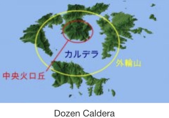
島前カルデラ
島前諸島は変わった形をしています。真ん中に高い山があり、その山が海に囲まれ、その外側に島がならんでいます。この地形は火山活動に由来するもので、大規模な火山噴火による火山体中央の陥没が作りました。このような火山性の陥没地形はカルデラと呼ばれ、日本では阿蘇山が有名です。
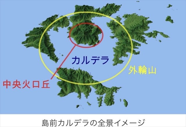
隠岐の島前カルデラは、およそ500万年前までに形成されたもので、国内有数の古さを持つことから、日本地質百選にも選ばれています。
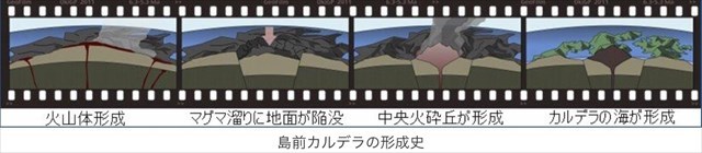
この島前カルデラは、3つのプロセスからできています。
1. 火山活動によってひとつの大きな火山が形成される。
2. 地下のマグマだまりが空洞化、中央が陥没すると同時に中心部で新たに火山が噴火する。
3. 噴火後の地殻変動で火山が半分海に沈み、侵食を受けて現在の地形になる。
これらのカルデラ地形は、外周の島々が堤防、内側のくぼ地が内湾、中央の山が灯台とも言い換えられるような役割を果たす地形を生み出し、島前で営まれて来た暮らしはこの地形と地質を前提にしたものでした。
陥没した中央部の範囲には2つの説があります。どちらの説をとるかで火山活動と侵食のどちらが現在の地形に大きな影響を与えているかの解釈が変わるため、詳しい研究が待たれています。
このキャッシュはアースキャッシュです。下記タスクを実行してください。
タスク
下記の質問の答えをキャッシュオーナーにメールしてください。
質問: 現在のカルデラの範囲は火山活動によって形成されたものでしょうか?それとも侵食によって形成されたのでしょうか?公開座標からカルデラ(内海)と外輪山の形状を観察して、あなたがそう考える根拠を教えてください。
English
"Oki" located on the Japanese sea in the northeast of Shimane prefecture is composed of four inhabited islands and numerous uninhabited islands. It is recognized as UNESCO Global Geopark in 2015 because of the geology where the history of the Japanese archipelago is found and the existence of a mysterious ecosystem.
Dozen Caldera
The Dozen Islands have an unusual landscape. In the middle is a tall mountain surrounded by a ring of islands. This landscape was formed by a large-scale volcanic eruption from the central mountain followed by a collapse of the land. This kind of volcanic depression is called a caldera. In Japan, Mt. Aso in Kyushu is one of the most famous calderas.
The Dozen Caldera was formed around five million years ago. As one of the oldest calderas in Japan it has been selected as one of the Top 100 Geological Landscapes.
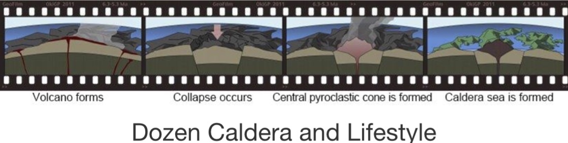
It was likely formed by the following process.
A large volcano was formed by volcanic activity.
As stores of magma within the volcano erupt, it becomes hollow and the center collapses.
Another eruption occurs from the center of this collapsed land and the central pyroclastic cone is formed.
Following the eruption, changes in the earth’s crust cause the bottom half of the volcano to sink under the sea. Erosion occurs forming the current landscape.
This cache is Earthcache. Perform the following Task.
Task
Send email the answer to the question send to cache owner.
Question: Which of the following is the formation factor of the current caldera range? Has the range of the current caldera formed by volcanic activity? Or was it formed by erosion? Observe the shapes of the caldera (inland sea) and the outer ring mountain from the public coordinates, and tell me the basis to think so.