Drangarnir - Amazing Geology
Drangarnier is the collective name for two sea stacks between the islet Tindhólmur and the island Vágar in the Faroe Islands. The individual names of the sea stacks are Stóri Drangur (en: Large cliff) and Lítli Drangur (en: Small cliff).
The Faroe Islands lie on the Eurasian plate between Scotland, Norway and Iceland. The islands are of volcanic origin and are made up of three layers of basalt, with the top and bottom layers resembling each other. The age of this rock is between 54 and 58 million years, with the oldest material at the bottom.

Attention: I received the following information: According to Faroese legislation walking on the in- and outfields require the landowners’ permission. You are only allowed to walk in this area with a guide. Hiking here without a guide can be fined.(For more information click the link.
Geology
Tuff
Tuff is a type of rock consisting of consolidated volcanic ash ejected from vents during a volcanic eruption. It is sometimes called tufa, particularly when used as construction material, although tufa also refers to a quite different rock. Rock that contains greater than 50% tuff is considered tuffaceous.
Basaltic Tuff
Basaltic Tuff are of wide spread occurrence both in districts where volcanoes are now active and in lands where eruptions have long since ended.
They are found in different places ans Colours. They are black, dark green or red in colour; vary greatly in coarseness, some being full of round spongy bombs a foot or more in diameter, and, being often submarine, may contain shale, sandstone, grit and other sedimentary material, and are occasionally fossiliferous.
Dolerite
Dolorite is similar in composition to basalt, which is eruptive (from volcanoes), and gabbro, which is plutonic. The differing crystal sizes are due to the different rate of cooling, basalt cools quickly and has a very fine structure, while gabbro cools very slowly, at great depth, and large crystals develop. Dolerite is intermediate.
Erosion
There are two different forces to form rocks: Weathering and Erosion Weathering is the breaking down of rocks by the action of the weather, plants or chemical action. In happens in situ - this means 'without movement'. This is the main difference between weathering and erosion. Erosion refers to rocks being broken down and moved away. Marine erosion is the wearing away and removal of rocks by the action of the sea.
Marine Erosion were defined in four main processes: They are corrasion (abrasion), attrition, solution and hydraulic action.
Corrasion (abrasion) this is where the bits of rock and sand that are carried in the waves are hurled at cliffs and grind them down. It is sometimes described as sandblasting.
Attrition is where the waves cause rocks and pebbles that they are carrying to smash into each other and break down. They become smaller and rounder.
Solution is where acids contained in sea water slowly dissolve certain types of rock. Sea water is very corrosive and slowly dissolves chalk and limestone. This increases the size of the cracks and joints in the rock so that the other forces of erosion can become more effective.
Hydraulic Action is the constant force of waves crashing on the shore. When waves crash against the cliffs they force air into cracks in the rock. The air is trapped, and pressure builds up. As the waves move back, pressure is released and the trapped air expands. Small explosions take place and weaken the rock, blasting fragments away.
The geology of Drangarnier.
The two sea stacks lie between the islet Tindhólmur and the island Vágar
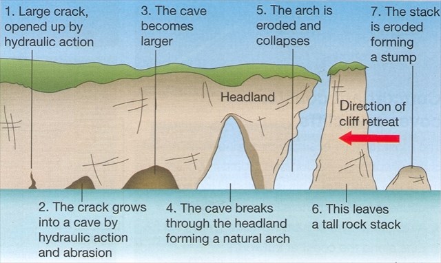
The first step in the process of headland erosion is for the sea to attack the foot of the cliff. It will begin to erode natural weaknesses in the rock (eg. a crack or joint) causing them to be widened by hydraulic action, wave pounding and solution. Abrasion and hydraulic action then widen these cracks still further, creating small sea caves at the foot of the cliff. Over time, continued erosion of these caves leads to an arch being formed when the sea caves break through the headland. A combination of wave attack at the base of the arch and weathering of the roof of the arch (by frost, wind and rain) weaken the structure until eventually the roof of the arch collapses. This creates a stack which is a column of rock that stands separate to the main headland. Sea spray then weakens the stack, and eventually it is eroded away leaving a stump. This will be covered by the water at high tide.
Arch or Bridge
The erosion forms mentioned can occur in all kinds of rocks. They are short-lived in directly erodible rocks or in environments with high erosion energy, such as the surf zone of cliffs. Durable large forms are particularly common in sandstone and limestone, as these resistant rocks are susceptible to solution by water and weathering. The description of such natural openings depends on their size, shape, formation and environment. Rock or natural gates and rock windows are of varying sizes, a rock or natural bridge was created by water, which often flows in the form of a stream or river. Rock, natural and stone arches are characterized by their shape, and often not created mainly by water. Surfing gates are created by the effect of the sea surf on cliffs. Such forms of erosion are called Natural Arch or Natural Bridge. After the division of the Natural Arch and Bridge Society, a Natural Arch is created without the involvement of running water. Such forms are common in the western United States and arise there mainly in sandstone. The Natural Bridge, on the other hand, is created by the action of flowing water and in many cases is constantly or temporarily flowed through by a stream or river. A further subdivision of these main groups is possible among other things about the form or the origin.
At the coordinates you have a wonderful view to Drangarnier
To log this Earthcache:
1. How do you think is this promentory formed? Is it an Arch or a bridge? Or is it something complete different?
Please explain your opinion based on accurate observations and descriptions of the given coordinates.
2. What type of stone do you see (Tuff stone, basaltic tuff, basaltic columns, other), how is the structure, colour, size, shape more angular or rounded? Do you see different level in this, please describe, what could be the reason? What is the estimatet hight of the hole on
Stóri Drangur
3. Do you see any other signs of erosion in this formation?
4. What do you think about Lítli Drangur, the single Stack. As described above, stacks could be the result of the erosion itself or the collapsing of an arch under gravity. What is your opinion in this case and why?
5. When you look through the whole of Drangarnier to Tindhólmur. What can you see very clearly at the cliff of Tindhólmur. What will happen in thousands of years?
You can imediately log this earthcache. I will contact you, if the answers will not fit.
You will find a got description of the hike at Faroe Islands: country guide- What to see/do in the Faroe Islands (scroll to Nr. 3)