ENGLISH VERSION BELOW
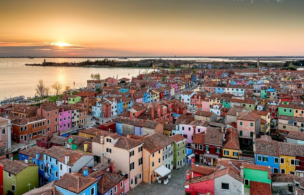
 Burano è una delle isole di Venezia, famosa per il suo merletto e per le case colorate. Dimora di grandi artisti come Baldassare Galuppi, Remigio Barbaro e Pino Donaggio, nonchè ispiratrice dell'Arte Buranella.
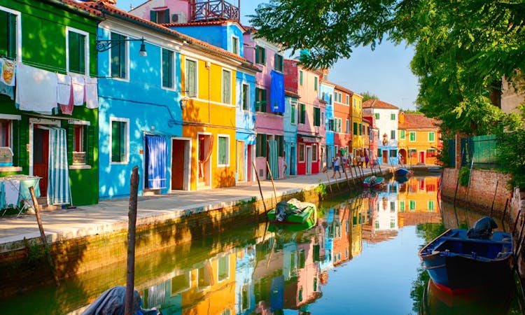
Moltissime riviste internazionali annoverano Burano tra le prime 10 città più colorate al mondo, anche se sarebbe più appropriato farla rientrare nelle prime 10 località più colorate al mondo o tra i 10 luoghi più colorati al mondo.
Questa multi è pensata per portarvi in giro per Burano alla scoperta di varie curiosità e caratteristiche tipiche che solo quest’isola o le isole della laguna di Venezia possono offrire. Considerare circa 1 ora in tutto e buona passeggiata.
Storia
Gli abitanti di Altino per sfuggire alle invasioni barbariche, si rifugiarono nelle varie isole della laguna, dando a queste i nomi delle sei porte della città: Murano, Mazzorbo, Burano, Torcello, Ammiana e Costanziaco, derivati appunto dai nomi delle porte di Altino.
Il nome Burano deriva dalla "Porta Boreana" chiamata così perchè posta a Nord-Est, direzione da cui soffia la bora.
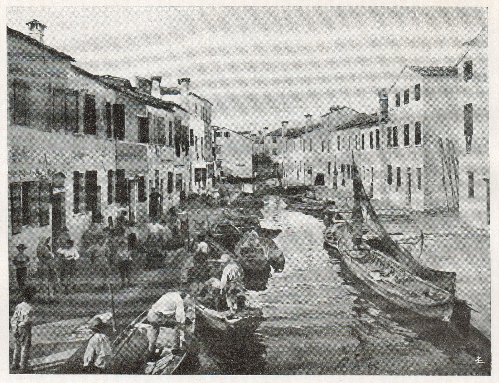
Le prime abitazioni delle isole erano fatte di palafitte, con le pareti perimetrali costituite di canne intrecciate e successivamente intonacate con fango. Erano costruzioni molto leggere composte da un solo vano, perchè il terreno era molle. Il pavimento era in terra battuta e i letti erano fatti di foglie secche.
Successivamente questi "casoni" vennero sostituiti da costruzioni in mattoni e alcuni dei restanti furono utilizzati per le attività di pesca e caccia.
Esiste una scuola di pensiero la quale ipotizza che Burano non sia sorta dove si trova oggi. Alcuni antichi testi scrivono che l'isola era collocata più vicino al mare e che gli abitanti l'abbandonarono a causa delle forti correnti marine che allagavano la terra e a causa dei venti che la corrodevano.
Altri testi invece scrivono che Burano sia sempre stata dove risiede oggi e che abbia sempre goduto di un'ottima posizione geografica: sembra infatti che la continua ventilazione dell'isola sia riuscita a tenere lontana la malaria.
Fin dai tempi della Repubblica di Venezia, Burano con la sua modesta popolazione allora di circa 8.000 persone, era un'isola di povera gente che viveva soprattutto di pesca e di agricoltura. Grazie all'abilità delle merlettaie cominciò a crescere, ad arricchirsi e ad espandere l'artigianato locale anche nei paesi stranieri.
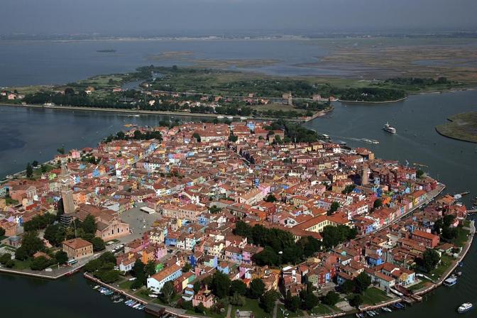
Il centro abitato di Burano si divide tutt'oggi in cinque frazioni collegate da ponti: San Martino Destro, San Martino Sinistro, San Mauro, Giucecca e Terranova che sono separate tra loro dai rispettivi canali: Rio Ponticello, Rio Zuecca e Rio Terranova.
L'ultima modifica morfologica apportata all'isola consiste nell'interramento del canale principale al fine di ottenere la piazza, la quale porta il nome del noto musicista Baldassare Galuppi.
E adesso inoltriamoci tra le calli di questa bellissima isola alla scoperta di varie curiosità
Vera da Pozzo (N 45°29.213' E 12°24.972')
Vera da pozzo è un termine tipicamente veneziano; con esso si definisce la costruzione lapidea sovrapposta alla canna del pozzo ed a protezione della sua apertura. All’inizio fu un elemento semplicissimo con funzioni di sola sicurezza e, col passare del tempo, divenne un ricco e pittoresco ornamento di piazze e cortili.
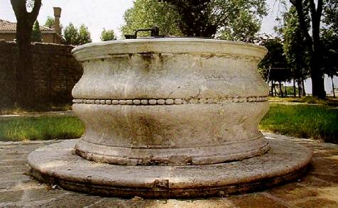 La vera, che con termine architettonico si dice puteale, nel corso dei secoli venne acquistando forme d'arte sempre più elaborate e complesse. Modeste o sfarzose, sopraelevate di uno o più gradini rispetto al piano stradale (qualche volta con vaschette alla base per la sete dei cani e dei piccioni), assumono il carattere di piccoli monumenti a forma cubica, circolare, poligonale; hanno forma di capitello, si arricchiscono anche di sostegni marmorei o metallici sui quali applicare la carrucola per farvi scorrere la corda del secchio. Variatissima e fantasiosa la decorazione a rilievo: piante, festoni di frutta e di fiori, fogliami arricciati, putti, angioli reggiscudo, pavoni affrontati, teste leonine, motivi allegorici, iscrizioni morali. Il pozzo privato reca sovente l'arma della famiglia patrizia che lo ha commissionato (di tali stemmi non risulta esservi esempio prima del secolo XIII"); i pozzi pubblici recano lo stemma del magistrato edile, ma anche il nome (o i nomi se più d'uno), che ne ordinò la costruzione, o l'effigie della Giustizia, alghe, tridenti, delfini e motivi analoghi messi a simbolo della repubblica dominatrice dei mari.
Qui ci troviamo davanti ad una di queste vere da pozzo, e come potrete notare nessuna a Venezia e nelle isole è uguale all'altra. Ora cercate la scritta nella vera da Pozzo e contate il numero di lettere della prima parola della seconda riga. Togliete 10 ed avrete A
Altana (N 45°29.169' E 12°24.981')
L'altana è un vassoio di assi di legno esposto a tutti i soli e a tutti i venti, poggiato sui tetti. Non si tratta propriamente di un terrazzo. E' retta da pilastrini, forse con un fianco poggiato all'abbaino attraverso il quale, spesso battendo la testa e dopo essersi arrampicati all'interno della casa attraversando il sottotetto, si sbuca all'aperto.
L'altana è area, traforata; il pavimento è fatto di assi tra le quali passa luce e aria. Non andate sull'altana con il vostro anello preferito: andrà presto in canale, o in bocca a un gabbiano che passa.
L'altana nelle case veneziane aveva 3 scopi principali:
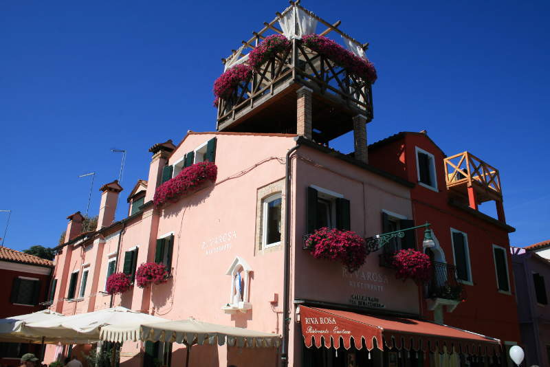 Poter stendere ad asciugare i panni (essendo le calli strette dalle finestre passa poca luce diretta e quindi erano i luoghi perfetti dove stendere la biancheria)
- Come luogo romantico, dove portare l'amata/o ad ammirare tra le calli, la luna e il panorama della laguna
- Come solarium, ma in modo diverso da come lo conosciamo oggi. Infatti all'epoca il colore pallido della pelle era segno di bellezza nonchè di ricchezza, perchè mentre la povera gente (pescatori e contadini principalmente) passavano molto tempo sotto il sole avendo cosi la carnagione scura, la nobiltà restando tra i palazzi aveva una carnagione molto più chiara. Allora le ragazze in cerca di marito, per poter ingannare le proprie origini si portavano su queste altane tutte coperte, con un cappello a tesa larga ma con un foro in cima, da dove far esporre solamente i capelli. Questi dopo varie ore e giorni al sole si schiarivano e cosi queste ragazze potevano ambire a partecipare alle feste nobili, essendo anch'esse di carnagione chiara e di capigliatura bionda/castano chiara (altro segno di bellezza).
Da queste coordinate vedrete verso sud un'altana. Nella casa sulla destra troverete una targa. Il numero di lettere del monte dove è morto il capitano è la lettera B
La raccolta dell'acqua e l'acquedotto (N 45°29.193' E 12°25.128')
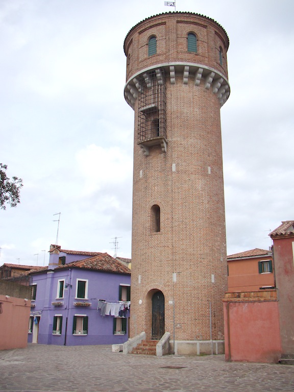 L'approvvigionamento idrico fu sempre problematica fondamentale a Venezia e nelle isole limitrofe. Date le particolari caratteristiche idro-geologiche della laguna, i cittadini avviarono già nell'Alto Medioevo la costruzione di cisterne sotterranee, comunemente definite pozzi. Per parte sua, il Governo dell'isola incoraggiò, promosse e coordinò la realizzazione d'impianti idrici.
Il pozzo veneziano si differenzia dal pozzo artesiano ordinario in quanto, per le particolari caratteristiche idro-geologiche della laguna di Venezia, l'acqua non veniva ricavata accedendo a una fonte sotterranea ma esclusivamente tramite raccolta e filtraggio dell'acqua piovana, sfruttando la natura argillosa e quindi sostanzialmente impermeabile del sottosuolo veneziano.
La costruzione di un pozzo era alquanto complessa. Era necessario innanzitutto poter disporre di una superficie di raccolta sufficientemente ampia attorno al pozzo vero e proprio, verso la quale far convergere l'acqua piovana: per tale motivo i pozzi veneziani si trovano pressoché esclusivamente nei campi o nelle corti più ampie.
Una volta individuata, l'area, di pianta rettangolare o quadrata, veniva scavata per una profondità di cinque o sei metri, rivestita di uno spesso strato di argilla impermeabile (la crea) e riempita con strati di sabbia di fiume di diversa finezza, che svolgevano la funzione di filtro. In alcuni casi, per poter raggiungere la profondità necessaria, si ricorse alla sopraelevazione di parte o dell'intero campo: questo tipo di soluzione si può vedere molto chiaramente in Campo San Trovaso, in Campo Sant'Angelo e nella Piazzetta dei Leoncini, di fronte alla sede del Patriarcato.
L'acqua piovana veniva raccolta tramite due o quattro tombini in pietra d'Istria, detti "pilelle", disposti in modo simmetrico rispetto alla canna del pozzo. Per limitare le dispersioni, sotto i tombini veniva realizzata una struttura in mattoni a forma di campana, aperta sul fondo, per convogliare quanta più acqua piovana possibile direttamente verso le sabbie di filtraggio. Tutta l'area circostante i tombini veniva inoltre sopraelevata in pendenza per favorire la raccolta dell'acqua piovana.
La canna del pozzo, posta al centro dell'area di raccolta, poggiava su un disco di pietra d'Istria e veniva poi realizzata con mattoni speciali, detti pozzali, che consentivano all'acqua piovana filtrata di entrare nella canna. La parte sporgente, rialzata e accessibile tramite uno o due gradini sempre in pietra d'Istria, veniva terminata con la cosiddetta vera da pozzo, solitamente anch'essa in pietra d'Istria rifinita con decorazioni, che fungeva sia da parapetto che da sostegno per la carrucola con cui le donne veneziane attingevano l'acqua tramite secchi. Alcune di queste vere, specie nel caso dei pozzi più antichi, furono ricavate da grandi capitelli provenienti da costruzioni di epoca romana.
L'area del pozzo veniva infine ricoperta di uno strato di muratura su cui appoggiare i masegni della pavimentazione che veniva raccordata con il resto della pavimentazione del campo o della corte. In alcuni casi i limiti dell'area del pozzo sono evidenziati a livello della pavimentazione pedonale da lastre in pietra d'Istria che circondano tutta la struttura.
Ora però tutto è cambiato e troviamo una torre dell'acquedotto con acqua proveniente dalla terraferma. Cercate il numero civico dell'acquedotto e sottraete la prima cifra all'ultima (xyz -> z-x). Questa cifra sarà C
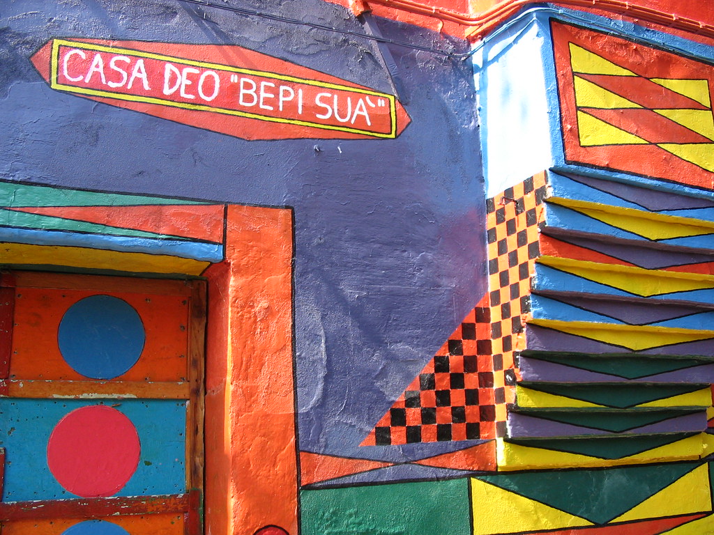
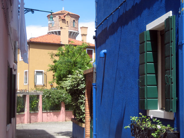
Case colorate e Bepi Suà (N 45°29.141' E 12°25.095')
La caratteristica principale che salta subito all'occhio di ogni visitatore di Burano è la vivacità dei colori che contraddistingue le varie case dell'isola. L'origine del perchè proprio in quest'isola si sia scelta questa vivacità di colori si mescola tra la storia e la leggenda. Una versione parla di segno distintivo della famiglia perchè il cognome non era sufficiente. Infatti essendo un'isola (e tra le più lontane a Venezia) la diffusione dei cognomi era molto limitata (cosi come a Chioggia, l'esempio più famoso di questa caratteristica) e quindi il solo nome e cognome non bastava a distinguere la persona; e così l'associazione con un nomignolo e il colore della casa aiutava maggiormente l'identificazione di chi si parlasse. L'altra versione, quella più plausibile, invece è data come segno di riconoscimento per i pescatori nelle giornate di fitta nebbia (molto frequente più che a Venezia) che una volta rientrati nell'isola potevano facilmente orientrarsi tramite i colori delle case.
 Ora, qualunque sia la versione vera, capirete che il colore della casa non era quindi solo un vezzo, ma una necessità, quindi la modifica del colore (mantendendo sempre le case in tinta unita) doveva essere autorizzato dal magistrato e fino alla metà dell'ottocento questa regola è risultata valida.
Una volta abrogata questa legge Burano però è rimasta tale, se non per la casa di un artista che ha racchiuso l'essenza dell'isola nella facciata della sua casa, Bepi Suà.
Bepi, al secolo Giuseppe Toselli, (Suà in veneziano significa sudato) oltre ad essere un amante della pittura era anche un appassionato di cinema. Passione nata con il suo lavoro al Cinema Favin, dove era stato impiegato come uomo delle pulizie e manutentore. Quando il cinema chiuse, si mise a vendere caramelle nella Piazza Galuppi di Burano: di qui l'appellativo di Bepi delle Caramelle.
Fino ai primi anni ottanta, nelle calde serate estive, organizzava il cinema all'aperto nel suo campiello: dopo aver appeso un lenzuolo bianco alla parete della sua abitazione, proiettava cartoni animati e film divertenti per dilettare i bambini di Burano.
Alle coordinate vi troverete di fronte alla casa di Bepi Suà e cercate il numero civico. Sottraete la prima cifra alla seconda (xyz -> y-x) ed avrete la lettera D
Le palafitte e il campanile storto (N 45°29.065' E 12°25.131')
Venezia e le isole sono state costruite come se fossero in una palude poco profonda, per cui la zona da edificare veniva dapprima solidificata piantando dei pali di legno appuntiti (larice o rovere), corti e nodosi fino a raggiungere uno strato di terreno particolarmente duro e compatto di argilla, detto caranto, di particolare consistenza, che si trova ad una decina di metri sotto lo strato di terreno superficiale della Laguna.
La infissione dei pali viene effettuata secondo un allineamento multiplo, lungo la striscia di terreno sopra la quale si eleveranno i muri perimetrali e di spina che sorreggeranno gran parte del peso dell'edificio.
Se lo strato di caranto è troppo profondo e i pali non arrivano, del tutto o in parte, a conficcarvisi, la sottofondazione viene fatta per costipamento. In tal caso i pali vengono piantati su tutta la superficie sopra la quale poggerà l’edificio, prima chiudendo il perimetro con una fitta palificata e procedendo poi all’interno con un disegno a spirale verso il centro della zona.
Capita nel caso di edifici molto pesanti (come nel caso dei campanili) che tra il peso dell'edificio stesso, che per l'azione del moto ondoso il caranto ceda e questo implica l'inclinazione della struttura fino al crollo (come è successo al campanile di S. Marco nel 1902).
Per approfondire ancora meglio lasciamo la parola a chi è decisamente più bravo a parlarne qui
Alle coordinate indicate potrete notare il campanile storto di Burano e qui dovrete cercate la targa relativa al COMANDO SUPREMO. Una volta trovata cercate alla nona riga il numero in formato 1.x.4. Il numero mancante (la x) è la lettera E
Burano e la sua storia (N 45° 29.039′ E 12° 25.081′)
 Alle coordinate indicate vi troverete di fronte alla casa di Gianfranco Rosso e nelle sue pareti racconta la storia dell’isola di Burano. Le maree, il carnevale, le merlettaie, i pescatori, le regate sono dipinte a mano sul muro rivolto verso il canale.
La storia del merletto della piccola isola Burano si perde nella notte dei tempi ed è legata a congetture o leggende. Per alcuni la tipica lavorazione buranella sarebbe connessa alla tradizione marinaresca degli abitanti della piccola isola, legati alla pesca e di conseguenza alla fabbricazione e alla riparazione in loco delle reti.
Le prime testimonianze della fioritura del commercio di merletti veneziani risalgono alla fine del XV secolo, accompagnate e seguite da un vero e proprio boom editoriale in Europa ed in Italia - specialmente a Venezia - che vide la pubblicazione di centinaia di libri, detti modellari, di disegni per merletti e ricami, ideati dai maggiori incisori e tipografi del tempo.
Qui vogliamo sapere il civico della casa e sottrarre la seconda cifra con la prima (è in formato Jxy -> y-x) ed otterrete F
FINALE
Ora che avete raccolto i vari indizi è giunto il tempo di raccogliere il frutto del vostro cammino. Recatevi alle coordinate:
N 45° 29.ABC′ E 12° 25.DEF′
Aiutatevi con la spoiler vista la bassissima ricezione GPS del luogo, se volete un altro aiuto usate il geocheck e buon divertimento. La cache è di dimensioni micro e all'interno contiene solamente il logbook. Portatevi una penna e buona caccia!

Welcome to Burano island, the colorful island of lace. Home of big artists like Baldassare Galuppi, Remigio Barbaro and Pino Donaggio, as well as inspirer of the Arte Buranella.
Many international magazines include Burano among the top 10 most colorful cities in the world, although it would be more appropriate to bring it within the first 10 most colorful places in the world or between the 10 most colorful locations in the world.
This multi bring you around Burano island to discover some curiosity and typical charateristics of this island and the Venice's lagoon. This multi during around 1 hour, so enjoy the walk.
History
 The inhabitants of Altino, escaping from barbarian invasion, find refuge in the islands of lagoon, giving them the names of the six doors of their thrown over city: Murano, Mazzorbo, Burano, Torcello, Ammiana e Costanziaca.
The name "Burano" arise from "Porta Boreana", the northern door of the city.
In these islands the first houses were build on palafittes, with walls made of woven canes and afterwards plastered with mud. They were very light buildings constituted by an unique room, because the ground was too tender. Beds were made of dry leaves.
Later these raw houses were changed with buildings made of bricks and the older ones were used like warehouses.
Some scholar believe that Burano was not risen where it is situated today. In some ancient text is written that the island was situated nearest the sea and that its inhabitants must escape from it because of the strong tidal wave.
Instead in other texts is written which the position of Burano was never changed and which it has saved the island from malaria.
Since the time of Venetian Republic, Burano had only 8000 poor inhabitants (now 3000) predominantly fishermans and farmers. Thanks to the craft of lace workers, the island grew economically, exporting its fantastic laces all over the world.
Today Burano is lotted into five joined by bridge quarters: "San Martino Destro", "San Martino Sinistro", "San Mauro", "Giucecca" and "Terranova", traversed by their mill runs "Rio Ponticello", "Rio Zuecca" and "Rio Terranova".
The last big change was the principal mill run's closing off to build the square, which takes its name from the famous musician Baldassare Galuppi.
Vera da Pozzo (N 45°29.213' E 12°24.972')
Vera da pozzo, Ring (Vera is the wedding ring) of the well, is a typically Venetian term; with it we define the stone structure superimposed on the shaft of the well and to protect its opening. At the beginning it was a very simple element with only security functions and, over time, it became a rich and picturesque ornament of squares and courtyards.
 The real, which with an architectural term is called puteal, over the centuries was acquiring increasingly elaborate and complex art forms. The enclosure keeps people from falling down a well otherwise open at grade level. When fit with a cast iron lid, as traditionally in the public squares, or campos, of Venice and their island, both the citizens and water supply were protected.
Putealia were used as an accessible point of water distribution, and as an aesthetic architectural element. Locations included public town squares and private courtyards.
Here we find ourselves in front of one of these Vera da Pozzo, and as you can see, none in Venice and in the islands is the same as the other. Now look for the writing on vera da Pozzo and count the number of letter of the first word on second row. Substract 10 and obtain A
Altana (N 45°29.169' E 12°24.981')
The altana is a wooden plank tray exposed to all the suns and winds, resting on the roofs. It is not really a terrace. It is supported by pillars, perhaps with a side resting on the dormer through which, often beating the head and after climbing inside the house through the attic, it comes out in the open.
The altana is a pierced area; the floor is made of boards between which light and air pass. Do not go on the roof with your favorite ring: it will soon go in the canal, or in the mouth of a passing gull.
The roof terrace in the Venetian houses had 3 main purposes:
 Being able to dry the clothes (being the narrow streets from the windows passes a little direct light and then were the perfect places to hang the laundry)
- As a romantic place, where to bring the beloved to admire among the streets, the moon and the lagoon and drink a glass of Spritz or Prosecco.
- As a solarium, but in a different way than we know it today. In fact, at the time the pale color of the skin was a sign of beauty and richness, because the poor people (fishermen and farmers mainly) spent a lot of time under the sun having so dark complexion, the nobility instead remaining among the buildings had a very complexion clearer. Then the girls looking for a husband, in order to be able to deceive their origins, they were brought on these roof terraces all covered, with a wide-brimmed hat but with a hole at the top, from where to expose only the hair. These after several hours and days in the sun cleared and so these girls could aspire to participate in the noble parties, being also of fair complexion and blonde / light brown hair (another sign of beauty).
From these coordinates you will see an Altana. On the house on the right of this one you find a plate. The number of letter of the mount (monte) where the captain dead is the letter B
The water supply and the aqueduct (N 45°29.193' E 12°25.128')
 Water supply was always a fundamental problem in Venice and in the neighboring islands. Given the particular hydro-geological characteristics of the lagoon, the citizens started in the early Middle Ages the construction of underground cisterns, commonly called wells. For its part, the Island Government encouraged, promoted and coordinated the construction of water systems.
The Venetian well differs from the ordinary artesian well because, due to the particular hydro-geological characteristics of the Venice lagoon, water was not obtained by accessing an underground source but exclusively by collecting and filtering rainwater, exploiting the clayey nature and therefore substantially impermeable to the Venetian subsoil.
The construction of a well was rather complex. First of all, it was necessary to have a sufficiently large gathering area around the real well, towards which rainwater can converge: for this reason the Venetian wells are found almost exclusively in the fields or in the wider courts. Once identified, the area, of rectangular or square plan, was dug for a depth of five or six meters, covered with a thick layer of impermeable clay (creates it) and filled with layers of river sand of different finesse, which they performed the filter function. In some cases, in order to reach the necessary depth, we resorted to the elevation of part or of the entire field
Rainwater was collected through two or four Istrian stone manhole, called "pilelle", arranged symmetrically with respect to the shaft of the well. To limit the dispersions, under the drains a bell-shaped brick structure was created, open at the bottom, to convey as much rainwater as possible directly to the filtering sands. The entire area around the manholes was also raised on a slope to encourage rainwater collection.
The shaft of the well, placed at the center of the collection area, rested on an Istrian stone disk and was then made with special bricks, called pozzali, which allowed the filtered rainwater to enter the barrel. The protruding part, raised and accessible by one or two steps, always in Istrian stone, was terminated with the so-called well, usually also in Istrian stone finished with decorations, which served as both a parapet and a support for the pulley with which Venetian women drew water through buckets. Some of these true, especially in the case of the oldest wells, were derived from large capitals from Roman buildings. The area of the well was finally covered with a layer of masonry on which to support the masks of the paving that was connected with the rest of the paving of the field or of the court. In some cases the limits of the well area are highlighted at the level of the pedestrian pavement by Istrian stone slabs that surround the entire structure.
But now everything has changed and we find a tower of the aqueduct with water coming from the mainland. Now searching the house number of the acqueduct and substract the last cipher with the first one (xyz -> z-x). This cipher will be C
Colored house and Bepi Suà (N 45°29.141' E 12°25.095')
The main feature that immediately catches the eye of every visitor of Burano is the liveliness of the colors that distinguishes the various houses of the island. The origin of why this island has chosen this vivacity of colors is mixed between history and legend. A version speaks of the distinctive sign of the family because the surname was not enough. In fact, being an island (and among the most distant in Venice) the spread of surnames was very limited (as well as in Chioggia, the most famous example of this feature) and therefore the only name and surname was not enough to distinguish the person; and so the association with a nickname and the color of the house helped the identification of those who spoke. The other version, the most plausible one, is instead given as a sign of recognition for the fishermen in the days of thick fog (very frequent rather than in Venice) that once back on the island they could easily orient themselves through the colors of the houses.
 Now, whatever the real version, you will understand that the color of the house was not just an estetic choice, but a necessity, so the change of the color (always keeping the houses in solid color) had to be authorized by the magistrate and up to half of XIX century this rule was valid.
Once this law has been repealed, Burano has remained so, except for the home of an artist who has enclosed the essence of the island in the facade of his house, Bepi Suà.
Bepi, born Giuseppe Toselli, (Suà in venetian means sweaty) besides being a lover of painting was also a fan of cinema. Passion born with his work at the Cinema Favin, where he was employed as a cleaning and maintenance man. When the cinema closed, he started selling candy in Piazza Galuppi in Burano: hence the name of Bepi delle Caramelle.
Until the early eighties, in the warm summer evenings, he organized the outdoor cinema in his little square: after hanging a white sheet on the wall of his home, he projected cartoons and funny films to delight the children of Burano.
At the coordinates you will be in front of the house of Bepi Suà and searching the house number. Substract the first cipher with the second (xyz -> y-x) and you obtain D
The foundation and the crooked bell tower (N 45°29.065' E 12°25.131')
Venice and the islands were built as if they were in a shallow swamp, whereby the area to be built was first solidified by planting pointed wooden poles (larch or oak), short and gnarled until reaching a particularly hard layer of soil. compact of clay, called "caranto", of particular consistency, which is located about ten meters below the layer of superficial soil of the Lagoon.
The piling of the poles is carried out according to a multiple alignment along the strip of land above which the perimeter and plug walls will rise, which will support most of the weight of the building.</>
If the layer of caranto is too deep and the poles do not arrive, completely or partially, to confide, the sub-foundation is done by compaction. In this case, the poles are planted on the entire surface above which the building will rest, first closing the perimeter with a piling and then proceeding inside with a spiral design towards the center of the area.
In case of very heavy buildings (as in the case of bell towers) happens that between the weight of the building itself, due to the action of the wave caranto yields and this implies the inclination of the structure up to the collapse (as happened at the bell tower of S. Marco in 1902).
To deepen even better, let's leave the floor to those who are much better at talking about it here (in italian)
At the coordinates indicated you can see the crooked bell tower of Burano and here you must find a plate about COMANDO SUPREMO. Once find it you've search on ninth row the number in format 1.x.4. The number replaced with x is the value of letter E
Burano and the history (N 45° 29.039′ E 12° 25.081′)
 At the coordinates indicated you will be in front of the house of Gianfranco Rosso and in its walls tells the story of the island of Burano. The tides, the carnival, the lacemakers, the fishermen, the regattas are hand painted on the wall facing the canal.
The history of the lace of the small island of Burano is lost in the mists of time and is linked to conjectures or legends. For some, the typical Burano's processing would be connected to the seafaring tradition of the inhabitants of the small island, linked to fishing and consequently to the manufacture and repair of the nets on site.
The earliest evidence of the blossoming of the Venetian lace trade dates back to the late fifteenth century, accompanied and followed by a real publishing boom in Europe and in Italy - especially in Venice - which saw the publication of hundreds of books, called models, designs for laces and embroidery, designed by the greatest engravers and typographers of the time.
Here we want to know the house number of this place. Substract the second with the first cipher (Jxy -> y-x) and obtain F

FINAL
Now you've collected all the number and it's time to search the cache. Go to this coordinate:
N 45° 29.ABC′ E 12° 25.DEF′
Use the spoiler because there's a very few GPS signal on final, and if you want another help use the geocheck and having fun. The cache is micro in dimension and inside you'll find only the logbook. Bring your pen and happy caching!