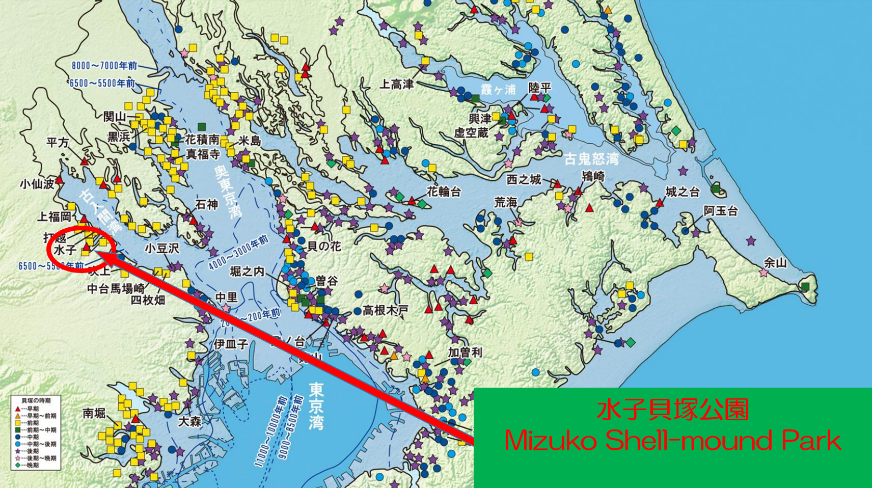
「縄文海進(じょうもんかいしん)」とは今から約6,000年前の縄文時代に起きた海水面上昇のことです。この時、関東平野の多くが海の中に沈み、ここ富士見市周辺は「古入間湾」に面していました。
何故このような現象が起きたのか?また、本当に海がここまで侵入していたのかを「水子貝塚公園」で確かめてみましょう。
"Holocene glacial retreat" is an ascent of sea level which rose now in the Jomon period approximately 6,000 years ago. Most of Kanto plains were sunk then in the sea, and around here Fujimi City faced "the Gulf of Old Iruma".
Why did such a phenomenon happen? In addition, Let's make sure of that the sea really invaded it to “Mizuko Shell-moundPark ”.
下の図は東京湾の海岸線の変遷を表したものです。①10,000年前は海岸線が今より沖にあり(海退)、東京湾は狭い入江でした。②6,000年前(縄文時代)は逆に陸地奥まで海岸線が侵入(海進)して、東京湾は複雑な形をしていました。③4,000年前は海岸線がその中間くらいの位置にありました。このことから海岸線は周期的に海進と海退を繰り返していることが分かります。
The lower figure expressed the change of the coastline of Tokyo Bay.①A coastline was in the offing (coastline regression) from now at 10,000 years ago, and Tokyo Bay was a small inlet. ②As for (Jyomon period), a coastline performed an invasion (coastline transgression) adversely to the land depths at 6,000 years ago, and Tokyo Bay had a complicated shape.③A coastline was at the position of the middle 4,000 years ago. From this, the coastline understands that it repeat transgression and regression periodically.
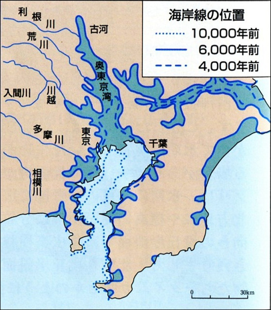

出典:日本第四紀学会資料
Source: Japan Association for Quaternary Research data"
では、何故このような現象が起きるのでしょうか?
その理由の一つが「気温変化」です。
下の図を見てみましょう。この図は気温の変化を表したものです。①10,000年前は今より約5℃気温が低かった。②6,000年前(縄文時代)は逆に約2℃高かった。気温が低かった10,000年前は最終氷期(氷期)にあたり、多くの水が氷として閉じ込められていたことから海水が減少して海岸線が海退していたと考えられます。また、気温が高かった6,000年前(縄文時代)は後氷期(間氷期)にあたり、その氷が溶けて海水面が上昇して海岸線が海進したと考えられます。
Then, why will such a phenomenon happen?
One of the reasons is "temperature change".
Let's check a lower figure. This figure expressed a change of the temperature.①Approximately 5 degrees Celsius temperature 10,000 years ago was lower than now.②As for (Jyomon period), approximately 2 degrees Celsius 6,000 years ago was high adversely than now.10,000 years ago, temperature was low is in the last glacial epoch, and it is thought that seawater decreases because much water was shut in ice, and a coastline did regression. In addition, 6,000 years ago (Jyomon period) is in postglacial age, temperature was high, and it is thought that the ice melts, and sea level rises, and a coastline did transgression.

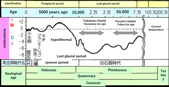
出典:萌えろ高校生物Ⅰ Study.10
Source: "Sprout" High school creatureⅠStudy.10"
次の図を見てください。この図は氷期、間氷期サイクルの変化を図式化したものです。そして、図の中央に書かれてあるように、その原因は①地球の地軸の傾きの変動、②離心率の変動です。 すなわち、①地軸の傾きが変わり日射が弱くなったり、②離心率の変動で地球と太陽との距離が離れたり、して北半球の夏季日射量が少なくなって寒冷化するため氷期となります。そして間氷期には温暖化して逆の現象が発生します。
Please check the next figure. This figure schematized the change of the cycle in a glacial epoch, an interglacial period. And, the cause are written in the center of the figure, ①The change of the inclination of the earth's axis ,② The change of eccentricity of the earth. In other words, ① The degree of leaning of the earth's axis changed, and sunlight becomes weak. ②Distance with the sun is separated from the earth by the change of the eccentricity. Two reason reduces quantity of sunlight in the summer of the Northern Hemisphere. As a result, it become chilliness, and it is in glacial epoch. And, The reverse phenomenon occurs in an interglacial period, it become warming.
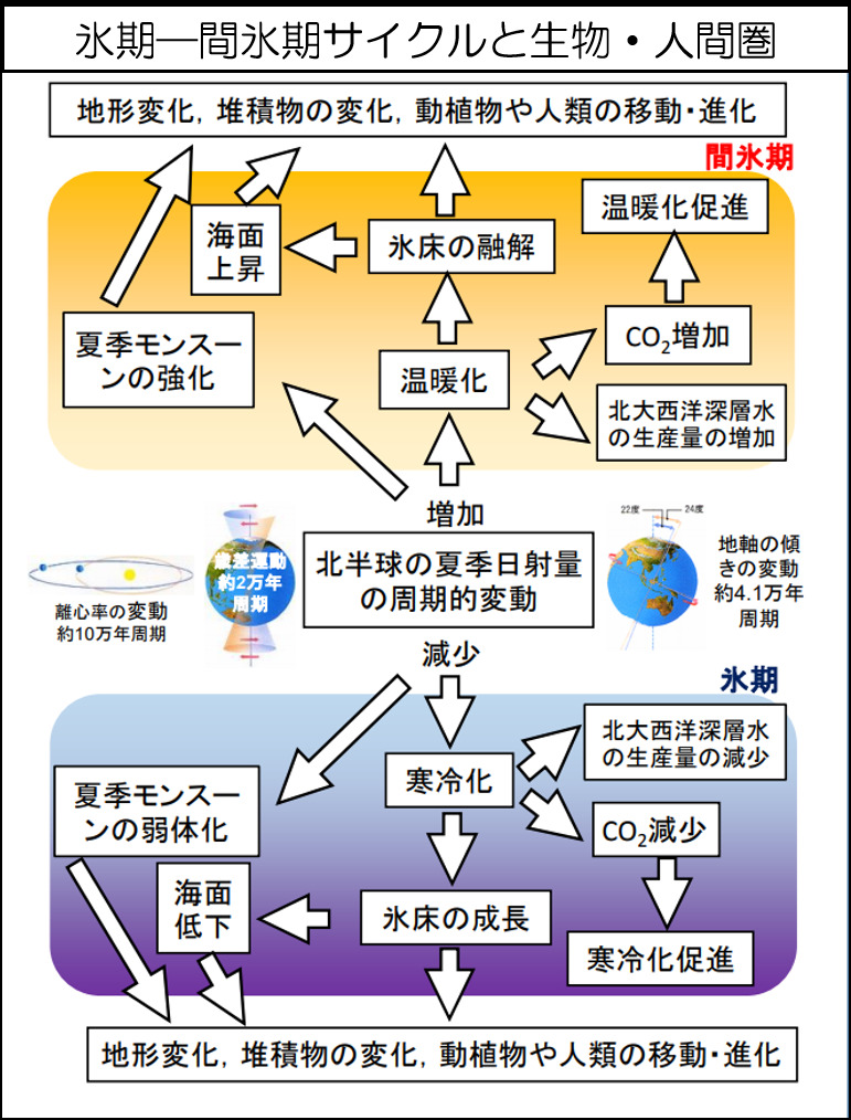
出典:日本第四紀学会資料
Source: Japan Association for Quaternary Research data"
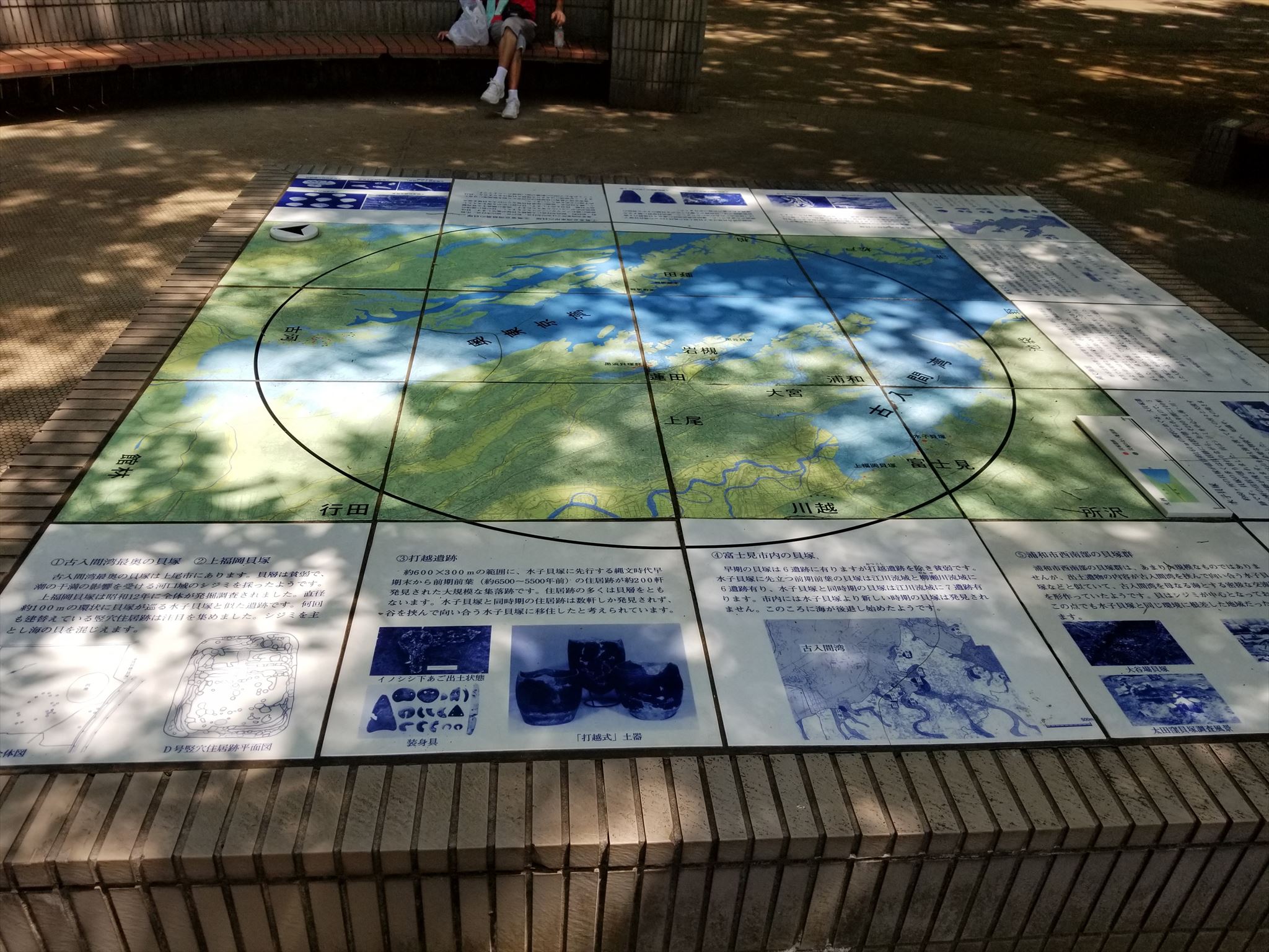
6,000年前(縄文時代)、海岸線が侵入(海進)していた頃、水子貝塚公園は海岸線の直ぐ側に位置していました。(次の図を参照ください) そして、ここには多量の貝塚が残されていました。もし、本当にここが海の側であればその痕跡が貝塚に残されている筈です。
In 6,000 years ago(Jyomon period), a coastline performed an invasion(transgression), Mizuko Shell Mound Park was located in the immediate side of the coastline(refer to the next figure).And, a large quantity of shell mounds were left here. The trace should be really left in a shell mound if here was the side of the sea.
You observe the showpiece in "Mizuko Shell Mound Museum" and "Jyomon period Fureai open space" in this park, and please answer it about TASKs.
出典:市民大学 ⑥富士見の歴史「海辺に暮らした縄文と 農耕文化の幕開け」資料
Source: The Fujimi City citizens' college theme ⑥ The history of Fujimi City " Sea side life of Jyomon period and opening scene of the farming culture" resumes
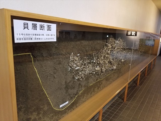
この公園内にある「参考地点 01:水子貝塚展示館」内の貝塚標本(左写真)や「参考地点 02:説明広場」にある展示物(右写真)を観察してTASKに答えてください。
Please observe the showpiece in "Reference Point 1: Mizuko Shell Mound Museum"(next left photo) and "Reference Point 2: Open space for an explanation board"(next right photo) in this park, and please answer it about TASKs.
1. 以下のTASKを実行してください。
2.キャッシュ名と解答をキャッシュオーナー(hikohohodemi)にメールしてください。
3. 答えはログに記入しないでください。
4.メールを送信したらファウンドログを上げてください。私の承認を待つ必要はありません。
1. Please carry out following TASK.
2. Please send e-mail this cache name and the answer to following questions to cache owner.(hikohohodemi)
3. Do not include this answer in your on-line log.
4. You do not need to wait for confirmation from me before posting online.
TASK 1
「参考地点 01:展示館」の中にある貝塚標本(写真参照)を観察してください。一番数が多い貝の名前は何ですか?
Please observe a shell mound at "reference spot 1". What is the kind of the shellfish with many numbers?
Please answer it refer to next photographs.
TASK 2
TASK 1と同じ貝塚標本を観察してください。一番大きな貝の直径は約何センチですか?
Please observe a shell mound at "reference spot 1".How many centimeters is diameter of biggest shellfish?
TASK 3
貝を取った場所が川でなく海であった証拠とは何でしょうか?あなたの考えを述べてください。
What is the evidence that here was the side of the sea, not a river ? And, Please explain your thoughts.
OPTION
水子貝塚公園の竪穴住居の前であなた、またはあなたのGPS機器の写真を撮り、ログにアップロードしてください。
Please upload the photo(you or your GPSr front pit dwelling house) to the log.
このearth cache の制作にあたりご協力いただいた"kajuyone さん"に感謝申しあげます。
Special Thanks : "kajuyone -san"