The cache container is a 7.62mm NATO ball ammunition tin.
All the clues and the final location lie within the 9.3 ha of Bunarong Park.
Parking may be found just off Wattletree Lane at S38° 09.360 E145° 09.368
This cache replaces my original Bunarong cache in this reserve which was placed in 2010 and had only 37 finds in its 8 years until it had to be archived after stages were destroyed by vandals. Anyone returning here for this new challenge will find the landscape much changed since the placement of the original.
Bunarong Park is named after the aboriginal tribe who originally lived in the Frankston area. Aboriginal stone implements found in the 1940s suggest that it was used as a campsite. At 90 metres above sea level, it would have been an excellent vantage point for the tribe to view the surrounding area.
Saved from becoming a site for sand extraction in the 1960s, it was later declared a reserve in 1978. To protect it from the housing developments and preserve it for future generations it was made a park in 1983.
Here is a link to the City of Frankston website with information about the park. There is a link to a brochure which you can print out if you wish, and it includes a trail map of the park.
Even in June when this cache was reviewed, there was a beautiful fragrance of wattle, and still some wonderful wildflowers about, as well as many varied types of fungi in the forest. Apparently the flowers are spectacular from September to November.
The Bunarong (also spelt Bunurong, Bunwurrung, Boonwerung, Bunurowrung, Boonoorong and Bururong) are Indigenous Australians of the Kulin nation, who occupy South-Central Victoria, Australia. Prior to European settlement, they lived as all people of the Kulin nation lived, sustainably on the land, predominantly as hunters and gatherers, for tens of thousands of years. They were referred to by Europeans as the Western Port or Port Philip tribe and were in alliance with other tribes in the Kulin nation, having particularly strong ties to the Wurundjeri people. The Bunurong are predominantly a saltwater people whose lands, waters and cosmos encompassed some 3,000 square miles (7,800 km2) of territory around Western Port Bay and the Mornington Peninsula. Its western boundary was set at Werribee. To the southeast it extended from Mordialloc through to Anderson Inlet, as far as Wilson's Promontory. Inland its borders reached the Dandenong Ranges, and ran eastwards as far as the vicinity of Warragul. (Wikipedia Reference)
Initial Coordinates
At the given coordinates you have a commanding view of the surrounding area.
Waypoint Two
Identify the pair of significant Casuarina trees found here:

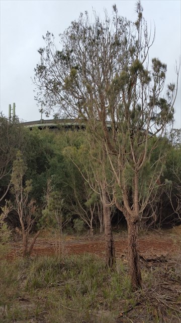
Go to them (approximately 75 metres from the initial coordinates) and stand next to them.
Project 52 metres on a bearing of 225 degrees
Waypoint Three
Identify the significant structure here.
You will find your final projection to GZ where moss doesn't grow.