You’re standing on the western edge of the confluence of the Bow and Elbow Rivers. The area is named "Elbow" in four Indigenous languages for the distinctive elbow-like crook the Elbow makes before the confluence. The Blackfoot call this Mohkínstsis or sometimes Mohkínstsisakápiyoyis, which means "Elbow Many Houses." The Stoney Nakoda name is Wincheeshpa. In both the Michif and Cree languages, the name is Otoskwunee. The Tsuut'ina people call it Kootsisáw. North West Mounted Police (NWMP) Commissioner Acheson Irvine was partly inspired in 1876 by this confluence in the naming of Calgary. Calgary means “clear running water” in Gaelic.
Vocabulary
Channel: a narrow body of water connecting two larger bodies of water; synonyms are passage, sound, and strait.
Confluence: a meeting point of two or more things; in geology, it refers to two or more bodies of water meeting.
Dam: a barrier built to hold back water; the result is a reservoir used for a water supply or electricity.
Floodplain: an area beside a body of water that is at risk of and/or has been covered by floodwaters.
Glacial silt: fine, granular-sized particles of bedrock mechanically created by glacial erosion.
Headwater: a tributary stream of a river that forms part of that river’s source.
Riparian: related to lands adjacent to rivers.
River: an aggregate of waters; each molecule of water has come from somewhere else.
Snowpack: layers of snow that seasonally accummulate in colder geographic regions/high altitudes; snowpacks' melting feeds rivers and tributaries.
Tributary: a body of water that flows into a larger body of water.
 river confluence
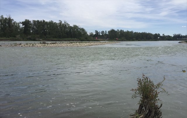
The Bow is the larger river north of the posted coordinates flowing west to east, and the Elbow is the smaller river in front of you flowing south to north. The Bow River is 645 kilometres long and has about 3 million people living alongside it and its tributaries. It takes its name from the reeds that grow along its banks from which local Indigenous people would make bows. The Bow goes through Banff, Canmore, and Cochrane before arriving in Calgary. The Bow's glacial headwater is the Bow Glacier in Banff National Park. The river ends when it joins the Oldman River near Medicine Hat farther southeast in Alberta.
The Elbow is a tributary of the Bow and a relatively short river at 120 kilometres; it winds its way through Bragg Creek, Springbank, and the Tsuut'ina Nation before coming to Calgary. Its glacial headwater is Rae Glacier on Mount Rae, which you can see from Calgary. The Glenmore Dam controls the Elbow's flow through much of Calgary, and the resulting reservoir provides 40 per cent of the city's drinking water.
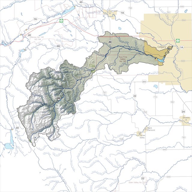 Map of Bow and Elbow Rivers from Bow River Basin Council (BRBC) used
under BRBC non-commercial use guidelines.
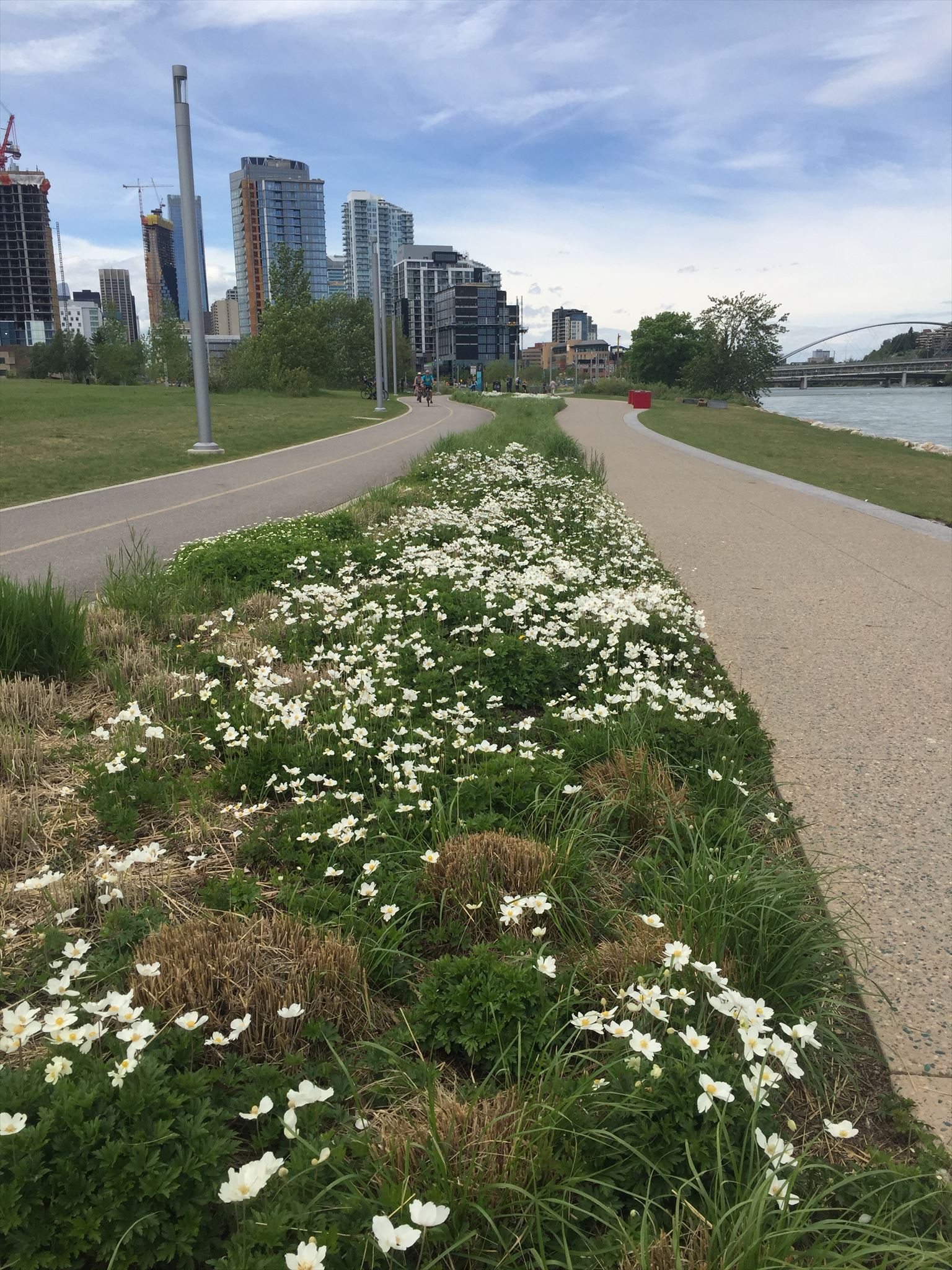 looking west along the Bow River path
Your trek here, whichever river pathway you took, went along one of Calgary's riparian floodplains. These floodplains were popular among Indigenous people and settlers because of ready access to fresh water, fishing, and hunting. Nowadays, you will find parks like the one you're currently in, neighbourhoods, businesses, and train stations. If you're here on a warm summer day, you'll likely spot at least a few rafts floating down the Bow.
While the floodplains are generally beautiful places to play, work, and live on, they also come with the eponymous hazard of being floodplains. Flooding data have been kept on both the Bow and Elbow Rivers since 1870. The graphs below show the water flow rates on the rivers.
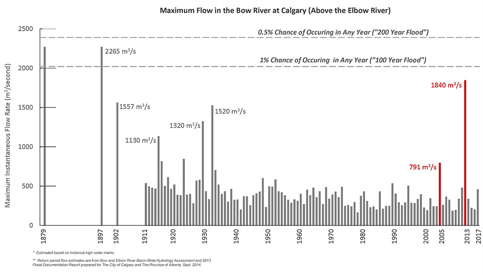
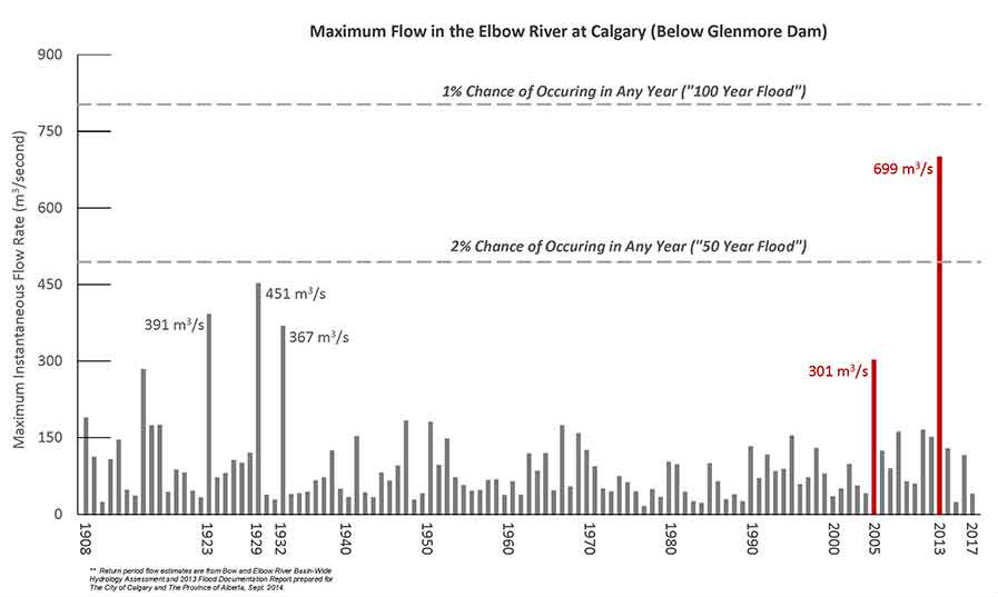 Source: City of Calgary
The most devastating flood to this area in historical record was the 2013 flooding. On June 19, 2013, more than 200 millimetres of rain poured on the snowpack over two days. The year’s heavy winter snowpack, a cool spring, and substantial June rain sent most of the year’s water supply down the rivers. This deluge not only affected what we see of the Bow and Elbow, but also their subterranean waters known as aquifers, which rose up into many homes and buildings. The water's murky appearance was from the force of the rivers pushing upriver silt and sediment downsteam. This is what the confluence area and East Village looked like after the flooding:
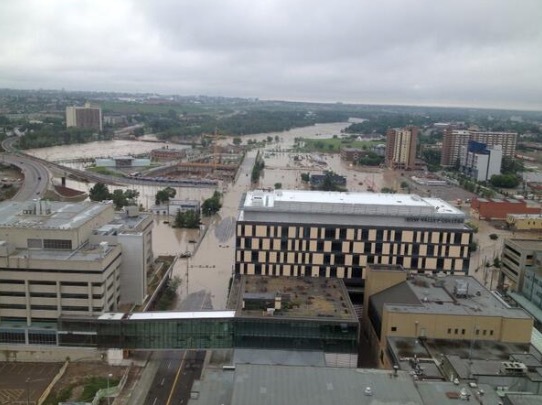
confluence area flooding in 2013
During most years, the rivers’ flows range from three to five times greater than in midwinter and nearly twice as high as in August. You can see this Earthcache’s posted coordinates in the above photo slightly centre right in the background.
Human activity since 1876 has wrought changes to the confluence as well. The cache coordinates used to be part of Goose Island. From 1914 to 1970, debris from nearby warehouses and demolition of police barracks were allowed into the river and filled the channel to Goose Island. In the 1970s, more debris was added when the interpretive centre at The Confluence Historic Site & Parkland was built. The interpretive centre proposed dredging the channel in 1996 to reestablish Goose Island, but the plan didn’t go forward because dams and development have altered the rivers such that Goose Island would have washed away.
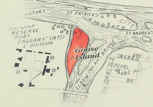
Goose Island circa 1905
Source: Government of Alberta
If you were here before development happened along the Bow River and in the floodplains and the disappearance of Goose Island, the appearance of the Bow's waters would also be different. In the summer, the Bow was a deep turquoise with glacial silt. During the fall, the waters would recede as cooling temperatures slowed the headwater glacier melt. Wintertime would find the waters shallow: they would freeze on top, and water would flood over top of the ice. Now, because of about a dozen dams upstream, the Bow usually flows more evenly throughout the year and much of the glacial silt is left behind in the dams. There is less water in summer and more in winter.
To log this Earthcache, send the answers to the following questions. Do not post the answers in your log, please.
1) What evidence do you see on the land at GZ that indicates human activity is again altering the land of the former Goose Island? OR If ground conditions such as snow and ice don't allow you to see the what's happening on the land at GZ, estimate in metres the width of the Elbow River where it starts to empty into the Bow.
2) What colour is the water of the Bow now? Why do you think the water might be that colour? Does it differ from the Elbow's colour? OR If the Bow and Elbow are frozen at the time of your visit, describe the Bow and Elbow's appearances.
Optional but fun bonus: post a photo of you/your group, your bike if you rode one here, your geodog if you have one, your GPS, or some combination thereof with the rivers. It would be neat to document the seasonal changes the confluence goes through.
Sources:
Bow River Basin Council
CBC News: "7 names for Calgary before it became Calgary" (https://www.cbc.ca/news/canada/calgary/calgary-names-elbow-1.3345967)
The City of Calgary
Elbow River Watershed Partnership
Government of Alberta
Heart Waters: Sources of the Bow River by Kevin Van Tighem