The Cherokee Bluffs are a series of bluffs on the south side of the Tennessee River downstream from downtown Knoxville. This feature is something that can often be overlooked as just a cliff, and its formation is tens of thousands of years in the making. This earthcache will show you one of these bluffs, how it was formed, and how the river will continue to meander even more in the future. The coordinates take you to the best observation point of one of the highest bluffs.
⠀
To log this cache, use the following info, your surroundings, and intellect to answer the following questions. Q1 is an observation; Q2 and Q3 can be answered by reading the cache page. Message me the appropriate answers and, most of all, have fun! Make sure to send your answers within a week of posting a found log.
⠀
1. Describe the appearance of the exposed rock of the bluff (height, color, type, texture, etc).
2. Where does the water flow faster: cliff side or park side?
3. Why is sand present on the shore of the park you are at?
4. (Optional, but encouraged): Take and post a picture of yourself with the bluff and/or river in the background.
———————
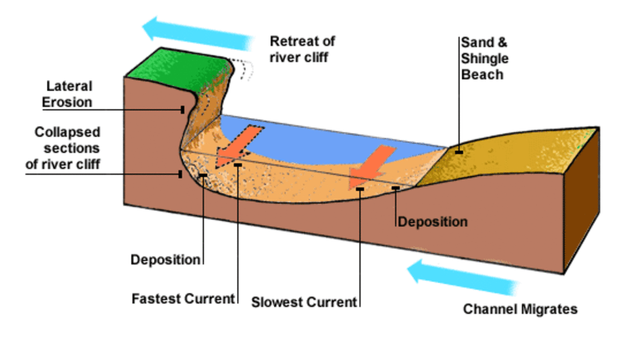
A bluff is a steep, rounded cliff made of rock or soil that usually overlooks a body of water, or where a body of water once stood. Bluffs may form along a river that meanders, or curves from side to side. A river can create a bluff when waves erode the river bank enough to carve deep into the layers of rock. This often happens at the bend of a river where water is pushed against the outside bank at higher speeds, causing erosion. The water taking the “outside track” around the bend has to travel a farther distance, thus moving faster than the water taking the “inside track.” The faster moving water on the outside of the bend erodes pieces of rock at the base of the bluff and anything above falls in. This is how the cliff you see here came to be.

On the inside of the bend, where the river flow is slower (in this case Sequoyah Hills neighborhood and park), material is deposited along the banks of the river, creating landforms that are called "point bars." Small particles such as sand, silt, tiny pebbles, etc, settle to the bottom as the water slows around the inside bends along these point bars. The sandy shore of this park and the flat topography of the park are evidence of this. Deposition of small particles over time have built this park and the neighborhood. The picture above shows this process, but the water flow direction is reversed. Come back to GZ in a few thousand years and you will find that both the shoreline and the cliff are farther away from you than it is now.
⠀

This earthcache is in a Knoxville city park. Permission has been granted by the Knoxville Parks & Rec director. There is a lot to enjoy at this park, including a boat ramp perfect for kayaking.