The cache is at the posted coordinates.

The view from the cache
I logged my first cache above 2,000 metres elevation on July 5, 2008. It was Cox Hill - A Cache for Susan by BVPete. Exactly 10 years to the day later I returned to Cox Hill and placed this cache. I'd love to be able to tell you that I carefully planned a return trip for the 10 year anniversary... but I can't. Believe it or not, it just worked out that way. Coincidence? Maybe. My subconscious not letting my conscious mind in on its intricate plan? Who knows? Whatever the reason, I bring you...
THE CHALLENGE
Find at least 100 traditional caches in Alberta with elevations of 2,000 metres or higher.
Use the challenge checker below to verify your completion of this challenge.

THE FINE PRINT
- Only finds on traditional caches count towards qualifying. They can be active, disabled, or archived.
- Only caches in Alberta, Canada count towards qualifying.
- Caches must have an elevation of 2,000 metres or more. Elevation data will be taken solely from Project GC.
You can hike up and sign the logbook in the cache any time you like. But you can't log an online "Found it" until you've both signed the logbook and met the challenge requirements. A screen shot of the output from the checker or copying-and-pasting the top portion of the "Example log" would be helpful but not required (I will check on Project GC myself). If you have blocked your statistics, you must provide suitable alternate proof that you qualify. I will also delete without notice any "Found it" log from any cacher that cannot be verified as meeting the requirements.

THE CACHE
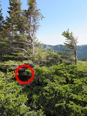
The cache is located near the end of a ridge that runs south from the summit of Cox Hill. It is a small, camoed LnL hung in a conifer. See the image below for the exact location of the cache (hey, if you hike all the way up here, I want you to be able to find it!). It's on the west end, north side of a group of conifers growing next to an outcrop of bedrock. You should be able to see the cache easily as you walk up to it.
Both parking locations are at trailheads. The Cox Hill trail from the Dawson RA was pretty rocky and rooty the last time I was on it. The Jumpingpound Ridge - North trail has a significant reversal between Jumpingpound Ridge and Cox Hill. Both trails will take you to within a hundred metres or so of the cache location. The off trail bit at the end is over an open alpine meadow with nary a bush in sight to whack. Standard backcountry disclaimers apply: be prepared.
Dedicated to BVPete