
Il Piz Boè è costituito da Calcare di Dachstein e formazioni di mare profondo, come il Rosso Ammonitico. Gli strati rocciosi sono però deformati, piegati e sovrapposti a causa dello scontro tra il continente africano e quello europeo che ha portato al sollevamento delle Dolomiti.
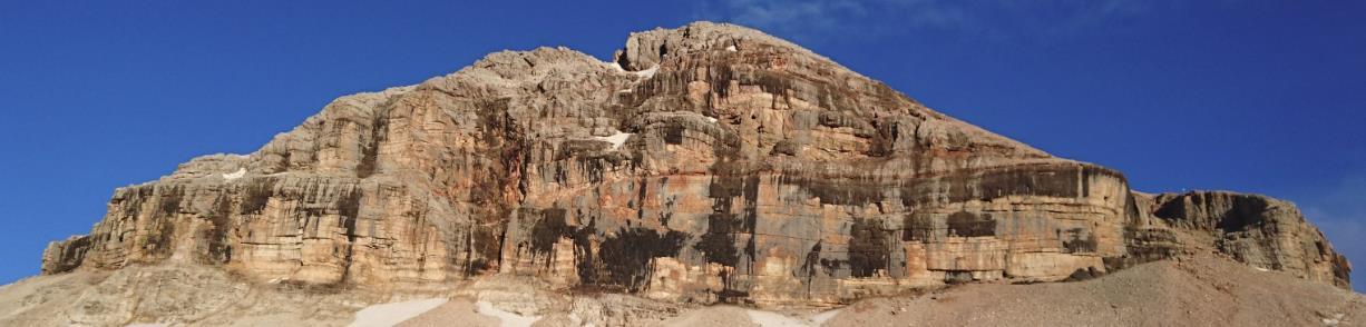
La parete di calcare di Dachstein alla base del Piz Boè. Sopra la parete il Rosso Ammonitico con alla base abbondanti concentrazioni di noduli di ferro e manganese.
Come è iniziato tutto!
Circa 225 milioni di anni fa, l’area dolomitica del Sella era occupato da un mare, profondo in alcune zone e basso in altre. Numerose erano le scogliere coralline costruite da alghe, spugne, bivalvi, gasteropodi, echinodermi e coralli che oggi costituiscono la Dolomia Cassiana. Le scogliere crescevano nelle zone di mare poco profondo espandendosi lateralmente verso i profondi bacini nei quali si accumulavano i prodotti dell’erosione ( Formazione di S. Cassiano ). Circa 223 milioni di anni fa un abbassamento del livello del mare blocca la crescita delle scogliere e alcune aree emergono. Poi la regione dolomitica torno a essere una piatta area costiera sulla quale si depositò la Formazione di Travenanzes ( un tempo chiamata Formazione di Raibl ) caratteristica per i vivaci colori rossi verdi e bianchi. La Formazione di Travenanzes separa con una caratteristica cengia la Dolomia Cassiana dalla più recente e sovrastante Dolomia Principale. La piana costiera viene ripetutamente invasa dal mare. A periodi di “acqua alta”, durante i quali le acque sono popolate da grossi bivalvi ( i megalodonti ), si succedono periodi in cui vaste aree restano all’asciutto; i foni fangosi esposti al caldo sole tropicale vengono ricoperti da tappeti di alghe. Si formano cosi le rocce principali delle Alpi meridionali, la Dolomia Principale. 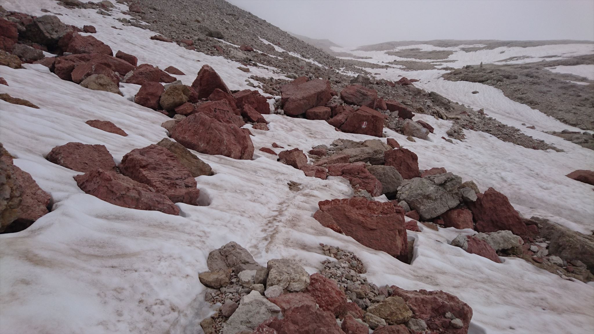 La Dolomia Principale è organizzata in cicli: bancate omogenee e massicce di dolomia cristallina con impronte di megalodonti si alternano a dolomia fittamente stratificata. Mentre il megalodonti rappresentano il momento in cui il livello del mare era alto, i livelle straterellati sono i tappeti algali ( stromatoliti ) deposti fuori dall’acqua. I cicli presenti nella Dolomia Principale sono circa un centinaio. Circa 210-215 milioni di anni fa la grande piattaforma su cui si era formata la Dolomia Principale sprofonda rompendosi in vari blocchi. La regione dolomitica da una vasta piana tidale diviene un banco tropicale poco profondo ma interamente sommerso. Non si formano più dolomie ma calcari, come il Calcare di Dachstein che si deposita sopra la Dolomia Principale. Nel Giurassico, tra 170 e 135 milioni di anni fa tutta la regione sprofonda ulteriormente. Si fa formando un grande oceano profondo più di mille metri sul fondo del quale si accumula il Rosso Ammonitico, un calcare rosso e nodulare caratterizzato dalla presenza di fossili di Ammoniti, cefalopodi estinti 65 milioni di anni fa e simili agli attuali Nautilus.
Per loggare questa Earthcache, andare in questa posizione e rispondere alle seguenti domande. Quindi pubblica una foto di te nel luogo del tuo log. Ovviamente, se non vuoi apparire nella foto, un oggetto personale nella foto è una prova sufficiente della tua presenza. (Secondo le linee guida di Earthcache, è richiesto il fotoritocco dal giugno 2019.)
1.) Alle coordinate della descrizione , puoi dare un'occhiata più da vicino ad alcune rocce del calcare di Dachstein. Descrive in poche parole il colore, struttura la sensazione.
2.) Guarda da qui sul muro (rockface) del Piz Boè. Qual è la demarcazione degli strati della formazione di Dachstein in Rosso Ammonitico? Guarda il rilievo della montagna.
3.) Al WP1 troviamo alcuni grandi blocchi di Rosso Ammonitico. Dai uno sguardo più da vicino a questa roccia. Con un po 'di fortuna puoi riconoscere le stampe fossili. Riesci a riconoscere le differenze con il calcare di Dachstein?
Puoi loggare immediatamente. Se qualcosa non è corretto, ti contatterò

Der Piz Boè besteht aus Dachstein-Kalkstein und Tiefseeformationen wie Ammonitischen Rot. Die Felsschichten sind jedoch deformiert, verbogen und überlappen sich aufgrund des Konflikts zwischen dem afrikanischen Kontinent und dem europäischen Kontinent, der zur Aufhebung der Dolomiten führte.
Die Kalksteinwand der Dachstein-Formation am Fuße des Piz Boè. Über der Mauer befindet sich ammonitisches Rot mit reichlich Eisen- und Manganknollen an der Basis.
Wie alles begann!
Vor etwa 225 Millionen Jahren war das Sella-Gebiet der Dolomiten von einem Meer bedeckt, das Bereichen tief und teilweise flach war. Es gab zahlreiche Korallenriffe, die von Algen, Schwämmen, Muscheln, Gastropoden, Echinodermen und Korallen gebildet wurden, die heute die Cassian Dolomiten bilden. Die Riffe wuchsen in den flachen Seegebieten und weiteten sich seitlich zu den tiefen Becken aus, in denen sich die Erosionsprodukte ansammelten (S. Cassiano Formation). Vor etwa 223 Millionen Jahren blockiert ein Rückgang des Meeresspiegels das Wachstum der Riffe und einige Bereiche tauchen auf. Dann wechselt die dolomitische Region zu einem flachen Küstengebiet, auf dem die Travenanzes-Formation (früher Raibl-Formation) abgelagert wurde, die für die Farben Rot, Grün und Weiß charakteristisch ist. Die Travenanzes-Formation trennt mit einem charakteristischen Felsvorsprung die Cassia-Dolomiten vom jüngsten und dominierenden Hauptdolomit. Die Küstenebene wird wiederholt vom Meer erobert. In Perioden von "Hochwasser", in denen die Gewässer von großen Muscheln (Megalodonten) bewohnt werden, gibt es Perioden, in denen große Gebiete trocken bleiben; Die schlammigen Stellen, die der warmen tropischen Sonne ausgesetzt sind, sind mit Algenmatten bedeckt. Die Hauptgesteine der Südalpen bilden so den Hauptdolomit. Der Hauptdolomit ist in Zyklen gewachsen: homogene und massive Ufer von kristallinen Dolomiten mit Megalodonteneindrücken wechseln sich mit dicht geschichteten Dolomitenkalken ab. Während die Megalodonten den Zeitpunkt darstellen, zu dem der Meeresspiegel hoch war, sind die Strarelliten die aus dem flachen Wasser abgelagerten Algenteppiche (Stromatolithen). Etwa einhundert dieser Zyklen bilden den Hauptdolomit. Vor etwa 210-215 Millionen Jahren kollabiert die große Plattform, auf der sich der Hauptdolomit bildete, in verschiedene Blöcke. Die dolomitische Region aus einer weiten Gezeitenebene wird zu einer flachen, aber völlig unter Wasser stehenden tropischen Bank. Es gibt keine Dolomiten mehr, sondern Kalkstein, wie der Kalkstein von Dachstein, der sich auf dem Hauptdolomit niederschlägt. Im Jura vor 170 bis 135 Millionen Jahren kollabiert die gesamte Region weiter. Es bildet einen großen Ozean mehr als tausend Meter tief, auf dessen Boden sich das Ammonitische Rot ansammelt, ein roter und kugeliger Kalkstein, der sich durch Fossilien von Ammoniten auszeichnet, ausgestorbene Kopffüßer vor 65 Millionen Jahren und ähnlich dem heutigen Nautilus.
Um diesen Earthcache zu loggen, begib dich zu dieser Location und beantworte nachfolgende Fragen. Anschließend postet zu eurem Log bitte noch ein Foto von euch an der Location. Wenn ihr selbst nicht auf dem Foto erscheinen wollt, reicht natürlich auch ein persönlicher Gegenstand auf dem Foto als Beweis eurer Anwesenheit. (Laut Earthcache Guidelines ist die Forderung eines Fotobeweises seit Juni 2019 wieder erlaubt.)
1.) An den Listingkoordinaten könnt ihr einige Gerölle des Dachsteinkalk näher betrachten. Beschreibt mit kurzen Worten die Farbe, Struktur die Haptik.
2.) Seht von hier auf die Felswand des Piz Boè. Wie ist die Abgrenzung der Schichten der Dachstein-Formation zum Rosso Ammonitico? Betrachtet das Relief des Berges.
3.) Am WP1 finden wir einige große Blöcke de Rosso Ammonitico. Schaut euch dieses Gestein genauer an. Mit ein wenig Glück könnt ihr fossile Abdrücke erkennen. Könnt Ihr Unterschiede erkennen zum Dachsteinkalk?
Danach könnt Ihr sofort loggen. Wenn irgendetwas nicht in Ordnung sein sollte, melde ich mich.

Piz Boè is made up of Dachstein limestone and deep-sea formations such as ammonite red. However, the rock strata are deformed, bent and overlap due to the conflict between the African continent and the European continent, which led to the lifting of the Dolomites.
The limestone wall of the Dachstein Formation at the foot of Piz Boè. Above the wall is ammonite red with abundant iron and manganese nodules at the base.
About 225 million years ago, the Sella area of the Dolomites was covered by a sea that was deep and partially shallow. There were numerous coral reefs formed by algae, sponges, shells, gastropods, echinoderms and corals, which today form the Cassian Dolomites. The reefs grew in the shallow sea areas and expanded laterally to the deep basins where the erosion products accumulated (S. Cassiano Formation). About 223 million years ago, a decline in sea levels blocked the reefs' growth and some areas appeared. Then the dolomitic region changed to a shallow coastal area where the Travenanzes Formation (formerly Raibl Formation) was deposited for the colors Red, green and white is characteristic. The Travenanzes formation separates with a characteristic promontory the Cassia Dolomites from the youngest and dominant main dolomite The coastal plain is repeatedly conquered by the sea. In periods of "high tides" where the waters are inhabited by large shells (megalodons), there are periods when large areas remain dry; The muddy spots that are exposed to the warm tropical sun are covered with algae mats. The main rocks of the Southern Alps thus form the main dolomite. The main dolomite has grown in cycles: homogeneous and massive shores of crystalline dolomites with impressions of megalodonts alternate with densely layered dolomitic limestones. While the megalodons represent the time when the sea level was high, the strarellites are the algae carpets (stromatolites) deposited from shallow water. About one hundred of these cycles make up the main dolomite. About 210-215 million years ago, the large platform on which the main dolomite formed collapsed into various blocks. The dolomitic region from a wide tidal level becomes a shallow but completely underwater tropical bank. There are no more dolomites, but limestone, like the limestone of Dachstein, which precipitates on the main dolomite. In the Jurassic, between 170 and 135 million years ago, the entire region collapsed further. It forms a large ocean more than a thousand feet deep, on the bottom of which accumulates the ammonite red, a red and spherical limestone, which is characterized by fossils of ammonites, extinct cephalopods 65 million years ago and similar to today's Nautilus.
To log this Earthcache, go to this location and answer the following questions. Then post a photo of you at the location to your log. Of course, if you do not want to appear in the photo, a personal item in the photo is enough proof of your presence. (According to the Earthcache Guidelines, photo-proofing has been required since June 2019.)
1) At the listing coordinates you can take a closer look at some stones of the Dachstein limestone. Describes in a few words the color, structure and how they feel.
2) Look from here to the rockface of Piz Boè. What is the demarcation of the layers of the Dachstein formation to Rosso Ammonitico? Look at the relief of the mountain.
3) On the WP1 we find some big blocks de Rosso Ammonitico. Take a closer look at this rock. With a little luck you can recognize fossil prints. Can you recognize differences to the Dachstein limestone?
After that you can give your log directly. If anything is not ok, i will contact you.
l'indice delle fonti:
· www. riannek.de/2012/geologie-der-dolomiten
· Wikipedia
· Fotos intrinsecamente