Here's a fun little nook on Kaua'i where I hope we can have a discussion about volcanic activity. This spot is a good reminder of the importance of volcanic activity to these islands! Stand at the geozone and take a good look around. Look out to sea and breathe in some fresh ocean air. Then look behind you, back at the island. It might not seem like it right now, but you're actually standing near the top of a very large mountain!
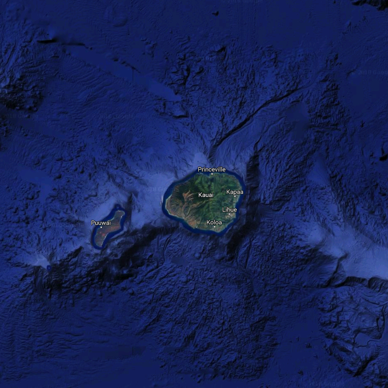
Take an overhead view of Kaua'i, courtesy of satellite imagery from Google, and you can appreciate the fact that the island is actually an enormous, mostly-submerged mountain. Even when you stand at these coordinates, at sea level, you are actually near the top of this mountain! The highest point on Kaua'i is Kawaikini at 5,243 feet in elevation. Combine that with nearby ocean depths northeast of Maui that are as deep as 18,860 feet, and we can estimate the "mountain" of Kaua'i to be as tall as 24,103 feet. That's only #78 on the list of world's tallest mountains, but it's a lot taller than any above-water mountain in the United States!
As we are all very aware, the Hawaiian islands were formed from underwater volcanoes. Magma was ejected from the volcanoes and built up into ever larger piles of rock over the course of millions of years, eventually forming huge underwater mountains. As these volcanic mountains continued to grow, they eventually broke the surface of the water and became islands.

That's all well and good, easily understood and accepted, except for one problem:
Most active volcanoes in the world are near the edges of moving tectonic plates, but the volcanoes of Hawaii are an exception!
You may have heard of the Pacific Ring of Fire. This is a horseshoe-shaped rim of geologic activity that outlines the Pacific tectonic plate. 90% of the world's earthquakes and 75% of its active volcanoes are found on this ring of fire. The ring perfectly outlines the border of the Pacific tectonic plate, which is moving in a NW direction at a velocity of about 1-2 inches per year, or about as fast as human fingernails grow.
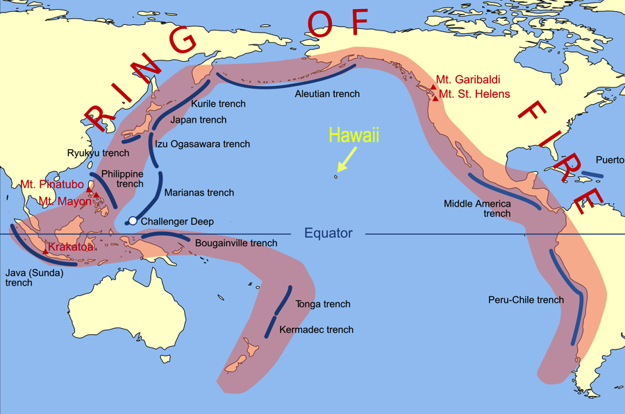
The Hawaiian islands are centrally located on the Pacific Plate, very far from any edges. This was confusing to scientists as the volcanic activity observed here didn't fit with their theories based on the usual observations. A new hypothesis about hot spots was then devised, by J Tuzo Wilson in 1963, to explain this deviation from the norm.
A hot spot is theorized to be a relatively fixed location on the Earth where mantle rock melts into magma, which causes volcanic activity despite being far from the edge of a tectonic plate. The hot spot remains relatively stationary (though perhaps not totally stationary) while the tectonic plate moves above it. The molten magma at the hot spot forms volcanoes, which remain active and grow while they are over the hot spot. But eventually the motion of the tectonic plate will drag the volcanoes away from the hot spot. Those volcanoes die out and new ones form as new mantle/crust are dragged onto the fixed hot spot. In this way, a chain of volcanoes is formed as the plate continues to move across the hot spot. This is how the Hawaiian islands were formed!

What's more, the Hawaiian islands are just the newest members of a longer chain of underwater volcanoes known as the Emperor Seamounts. This long chain of underwater volcanoes stretches to the northwest of Hawaii for over 3,600 miles. The theory is that the entire chain was formed in the same manner of interaction between the fixed hot spot and the moving tectonic plate. There is a slight bend in the chain of seamounts, and geologists are doing studies to determine whether the bend represents a change in direction of the tectonic plate, or if it was due to migration of the hot spot itself.
Coming back to this spot, there is a little more to say about the lava rock that you're standing on. Lava is named and classified depending on how it flowed, which gives it different shapes. The different types are:
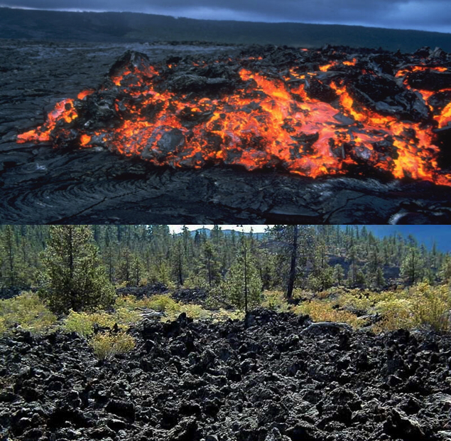
Pahoehoe (pronounced pa-hoey-hoey)
Slower-flowing lava that forms a protective skin that allows the surface of the flow to remain unbroken. This causes the flow to eventually harden in long, smooth, undulating, wavy, or ropy shapes.

A'a (pronounced ah-ah)
Quicker-flowing lava that "gets ahead of itself", and the outer skin layer rips apart into rough chunks of rock before the tears can be repaired by the more molten lava within.
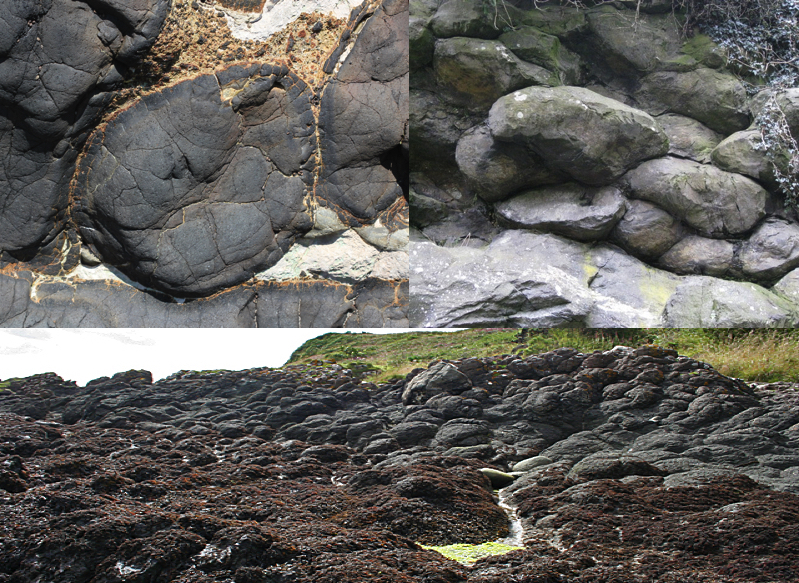
Pillow lava
This lava is exposed to water or ice, which causes rapid cooling of blobs of lava into smooth, pillow-shaped rocks. This lava often originates underwater and can pile up as the eruption continues.
INSTRUCTIONS TO LOG THE EARTHCACHE
Please send me the answers to these questions as a private message or email. Do not post the answers in your log. Once you have sent me the answers, you may log the cache as found. If I feel that your answers have shown lack of effort in studying this Earthcache or in visiting the site, I could delete your found it log.
1. Based on the information given here, can you predict where the next (newest/future) island would form in the Hawaiian island chain?
2. What type of lava do you think this is at the posted coordinates?
3. Notice how the rocks appear to be in discrete pieces. What is the approximate size (please estimate width x height) of the largest pieces you can see?
4. Do you think the lava rock here was a contiguous piece that is being shattered into pieces by erosion, or has it always been in these discrete pieces?
References
https://geology.com/usgs/hawaiian-hot-spot/
https://oceanexplorer.noaa.gov/facts/volcanic-hotspot.html
https://en.wikipedia.org/wiki/Hawaiian_Islands
https://www.nationalgeographic.org/encyclopedia/ring-fire/
http://www.geo.cornell.edu/geology/GalapagosWWW/LavaTypes.html
https://www.youtube.com/watch?v=5G8W9sZtBTM
https://www.youtube.com/watch?v=hmMlspNoZMs