[LKC] La Strada degli Eroi Traditional Cache
[LKC] La Strada degli Eroi
-
Difficulty:
-

-
Terrain:
-

Size:  (micro)
Please note Use of geocaching.com services is subject to the terms and conditions
in our disclaimer.
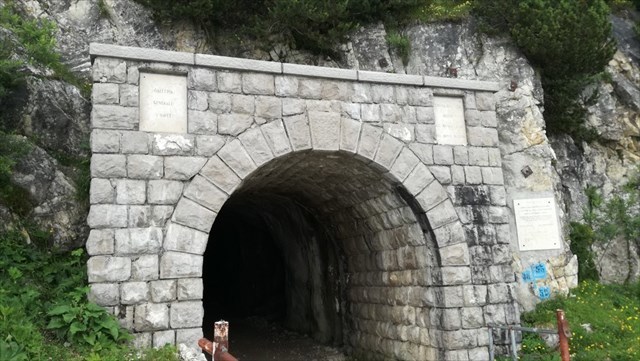
La cache è nascosta all'imboccatura della Galleria d'Havet, all'esterno sulla sinistra (salendo). Si tratta di un piccolo contenitore che contiene solamente il Logbook, per cui è necessario portare con se una penna per poterlo firmare. Il sito in cui è nascosta la cache rappresenta il punto di partenza vero e proprio della famosa "Strada degli Eroi".

La strada degli Eroi
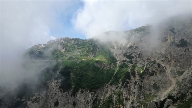
La strada degli Eroi vera e propria è il tratto lungo circa 2 chilometri che collega la Galleria d'Havet al rifugio Achille Papa, situato alle Porte del Pasubio, nel comune di Valli del Pasubio. Scavata sulla destra orografica delle pareti verticali a precipizio sull'impervia Val Canale, presenta un fondo naturale piuttosto dissestato.
Il nome deriva dal fatto che sulla parete rocciosa sono collocate delle targhe in onore delle 15 medaglie d'oro al valor militare che combatterono sul Pasubio durante la Grande Guerra.
Per estensione con il termine di Strada degli Eroi ci si riferisce all'intera rotabile della Val Fieno, nel comune di Vallarsa, che sale dal Pian delle Fugazze (1162 m), al confine fra la provincia di Vicenza e di Trento, e arriva fino al rifugio Papa (1928 m).
L'intero tracciato rifugio Achille Papa - Pian delle Fugazze fa parte del sentiero Europeo E5 e del Sentiero della Pace.
La strada, chiusa al traffico motorizzato (d'estate vi sono dei bus navetta che fanno spola fra il Passo e la Galleria d'Havet), è lunga nella sua interezza 10,6 chilometri, segnati da pietre miliari che ogni chilometro danno la distanza dall'inizio. Il fondo è naturale, tranne per alcuni tornanti asfaltati, con un percorso tortuoso nella Val Fieno per salire con pendenza piuttosto costante e mai particolarmente impegnativa se non nel tratto finale prima della Galleria d'Havet, lunga poche decine di metri, che permette di passare nella Val Canale appena sotto il crinale dello spartiacque.
Durante il conflitto mondiale era solamente un sentiero e venne in seguito allargata per permettere un comodo accesso alla Zona Sacra, in alternativa della strada degli Scarubbi in cui la neve permane molto più a lungo a causa dell'esposizione a nord. Chiusa al traffico motorizzato negli anni ottanta a causa della pericolosità del tragitto soprattutto nel tratto finale, è oggi molto frequentata dagli escursionisti sia a piedi che in mountain bike. Rimane infatti una delle principali vie d'accesso alla sommità del massiccio perché può essere percorsa anche da chi ha poca confidenza con la montagna.
Insieme alla strada degli Scarubbi rappresenta un eccellente percorso storico-culturale per chi pratica la mountain bike.
[Informazioni tratte da: Wikipedia]
English
The cache is hidden at the entrance of the "Galleria d'Havet", outside on the left (going up). It is a small container that contains only the logbook, so you need to bring a pen with you if you want to sign it! The site in which the cache is hidden is the real starting point of the famous "Road of the Heroes".
The Road of the Heroes
The "Road of the Heroes" is the 2 km long stretch connecting the Galleria d'Havet to the Achille Papa refuge, located at the "Porte del Pasubio", in the municipality of Valli del Pasubio. Excavated on the orographic right of the vertical walls on the impervious Val Canale, it has a rather rough natural background.
The name derives from the fact that on the rocky wall are placed plaques in honor of the 15 gold medals for military valor that fought on the Pasubio during the Great War.
By extension with the term of Strada degli Eroi refers to the entire rolling stock of Val Fieno, in the municipality of Vallarsa, which rises from Pian delle Fugazze (1162 m), on the border between the province of Vicenza and Trento, and arrives to the Pope refuge (1928 m).
The entire Achille Papa - Pian delle Fugazze refuge is part of the European path E5 and the Path of Peace.
The road, closed to motorized traffic, is 10.6 kilometers long in its entirety, marked by milestones that give the distance each kilometer from the beginning. The ground is natural, except for some asphalted hairpin bends, with a winding path in the Val Fieno to go up with a rather constant slope and never particularly demanding if not in the final stretch before the Galleria d'Havet, a few tens of meters long, which allows you to pass in the Val Canale just below the ridge of the watershed.
During the world war it was only a path and was later enlarged to allow easy access to the Sacred Zone, as an alternative to the Scarubbi road where the snow remains much longer due to exposure to the north. Closed to motorized traffic in the eighties because of the dangerousness of the route especially in the final stretch, it is nowadays very popular with hikers both on foot and by mountain bike. It remains one of the main access routes to the summit of the massif because it can also be traveled by those who have little confidence with the mountain.
Together with the road of the Scarubbi it represents an excellent historical-cultural route for those who practice mountain biking.
[Information taken from: Wikipedia]
Additional Hints
(Decrypt)
Fnyraqb, fhy yngb qrfgeb evfcrggb nyyn tnyyrevn, fbggb ha znffb / Tbvat hc, bhgfvqr gur pnir ba gur evtug, haqre n obhyqre
Treasures
You'll collect a digital Treasure from one of these collections when you find and log this geocache:

Loading Treasures